

Hiking Southern Utah:
Spectra Point Trail in Cedar Breaks National Monument
Written by Don Gilman
 Trail Name: Spectra Point Trail
Difficulty: Moderate (mostly due to elevation)
Elevation Gain: approximately 375 feet
Length: 2 miles
Time Required: 1-1.5 hours
Family-Friendly: Yes, but the altitude and steep drop-offs necessitate keeping a close eye on children
Summer has officially arrived, and with it comes the intense heat the St. George area is known for. For hikers, this can make hitting the trail a more difficult proposition. Fortunately, there are hiking options in southern Utah that won’t put hikers at as much of a risk for heatstroke. Cedar Breaks National Monument, which lies east of Cedar City, is a welcome refuge of cooler summer temperatures for heat-weary residents of the desert lowland. Perched at above 10,000 feet, the park is a unique mix of red rock architecture and alpine meadows and forests. With a fraction of the visitors who swarm Zion in summer, Cedar Breaks is a quieter destination that has a grandeur similar to the national parks the region is famous for. The Spectra Point Trail is an ideal hike for families and those wanting to quickly take in the awesome splendor of this unique place.
Access: To get to Cedar Breaks, head north on Interstate 15, take exit 57 to Cedar City, and follow Cross Hollow Road for 0.2 miles. Turn left onto Utah State Route 130, and proceed north through Cedar City for 1.9 miles to East Center Street (Utah State Route 14). Turn right and follow it out of town and into the canyon for approximately 18 miles. The highway will become increasingly narrow and steep as it gains thousands of feet of elevation, winding up toward the Markaugunt Plateau above. Turn left onto Utah State Route 148 North, and drive for another 5.5 miles until the visitor’s center is reached. There is a $5 per person fee, although children under the age of 15 enter free. The trail begins just south of the entrance booth.
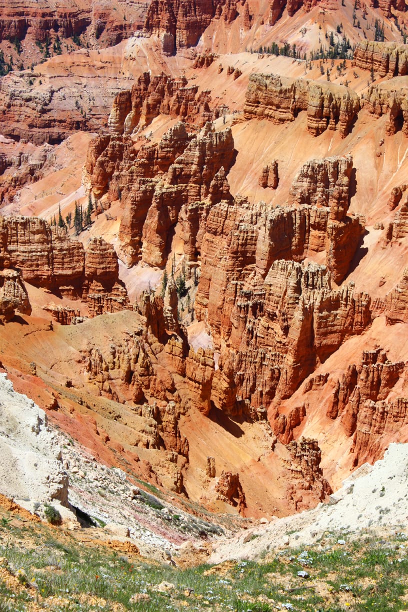
 The hike begins by winding through a short uphill section of fir trees and alpine shrubs but quickly reaches the breathtaking rim of Cedar Breaks. The earth looks like it is on fire, with vibrant hues of reds, oranges, and yellows. Towers, turrets, and fins resemble the walls of a Gothic castle. To the north, the mountain that is home to the Brian Head Ski Resort rises in a sweep of green to its 11,000-foot summit. Far down below in the west, Cedar City is visible.
Something to consider on this hike is the altitude. Since the rim of Cedar Breaks is well above 10,000 feet, altitude sickness is a very real possibility here, especially considering how quickly travelers gain altitude from the lowlands. Pay attention to each member of the hiking party, and do not press on if anyone begins to feel ill.
The trail along the rim is well-graded and fairly wide, and the uphill sections are minimal. The trail parallels the highway a few hundred yards away, but vehicles are rarely heard. After approximately one-quarter of a mile, a sign denoting a historical building is reached, and a short side trail ducks into the trees. Here, a small cabin is all that remains of the Cedar Breaks Lodge, which was torn down in the 1970s.
The trail continues on and begins to gain elevation as it heads toward the top of a small rise and a water tower. This short ascent can seem much more difficult than normal due to the elevation. From the water tower, the trail begins its descent towards Spectra Point, heading into the cool confines of the forest for a short distance. On the return, this downhill section is the most difficult part of the hike.
As the trail reaches the promontory of Spectra Point, the trees thin and the views open up once more, giving a glimpse of the full grandeur of Cedar Breaks. The path winds around a small ridge, and as it makes one final, mild descent, a small stand of bristlecone pines is reached. An informative sign explains that these are some of the oldest living organisms on earth. The twisted trees are a unique and intriguing aspect of this hike, and children, in particular, enjoy exploring their weathered, gnarled trunks.
A few yards from the sign, the trail reaches a junction. The left-hand fork continues on to the Ramparts Trail while the Spectra Point continues straight ahead for 75 yards. At the end of the path, a railed viewpoint gives the final and best views of the entire hike. Sharp eyes might spot several arches in the formations immediately below the viewpoint. When ready, return on the same trail to the visitor’s center parking area.


