

Our Geological Wonderland: A self-guided field trip in and around St. George
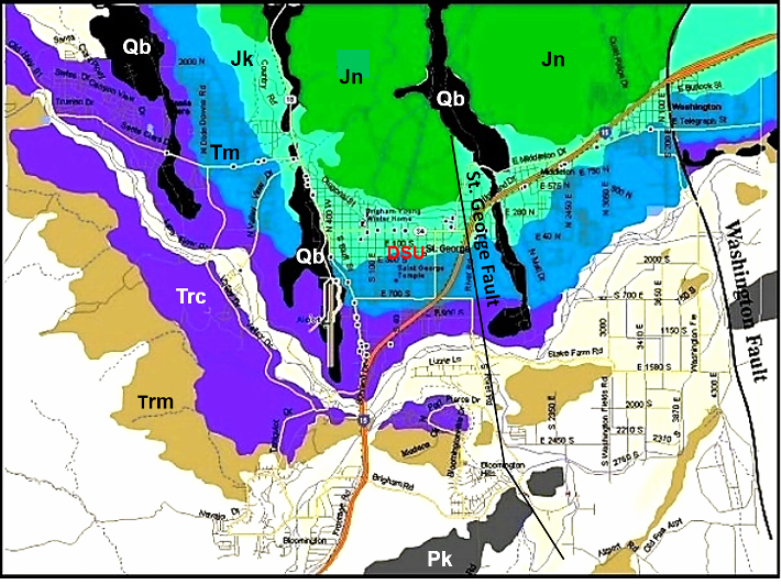
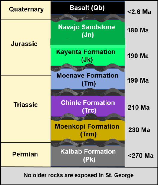
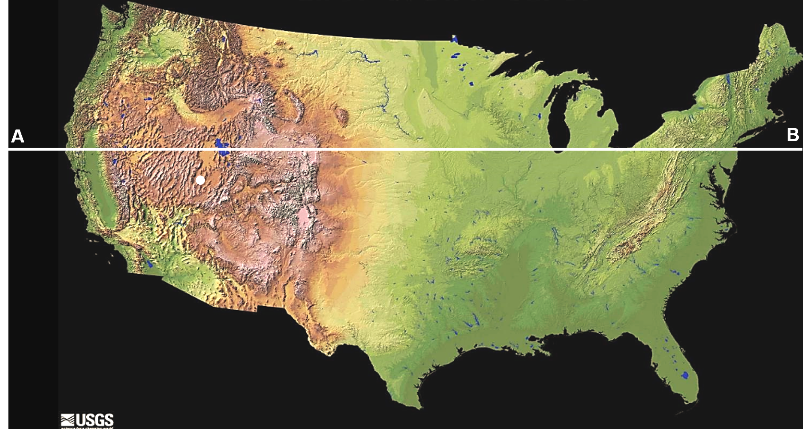
The purpose of this self-guided field trip is to illustrate easily accessible locations within the St. George area where you can view some features of our geological wonderland. Information for each location includes the kinds of rocks (when, where, and how they formed), structural features (unconformities, folds, faults, and joints), geomorphology (why are there hills and valleys), and some of the geologic hazards that occur (slumps, slides, rock falls, volcanoes, and earthquake faults). A geologic map and a stratigraphic column provide a basis for observing the rocks and other features (Figures 1 and 2).
Many of these field trip stops are along well traveled roads. Be cautious. Park well off the roads in designated parking areas, and watch for traffic.
This field trip is organized to begin with the oldest rock unit and generally progress upwards in geologic time to younger rock units, which are generally exposed as you travel north through the city.
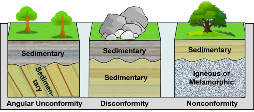
Unconformities noted in Figure 2 are very significant geologic features. They represent times when no rocks were being deposited in an area and existing rocks were being eroded away. This time of non-deposition and erosion was then followed by younger deposition covering the erosion surface. Therefore, unconformities provide evidence to indicate a particular area was above sea level as land for an interval of time. Think of where we live in Washington County today, where our scenic “red rocks” are being eroded away. Three main types of unconformities are recognized, two of which occur in our area and can be seen at some field trip stops (Figure 3).
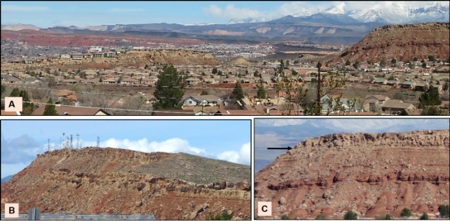
The following panorama, which was taken from the east side of Middleton Black Ridge (Foremaster Ridge) provides an overview for most of the rock formations that are exposed at the surface in St. George and Washington (Figure 4).
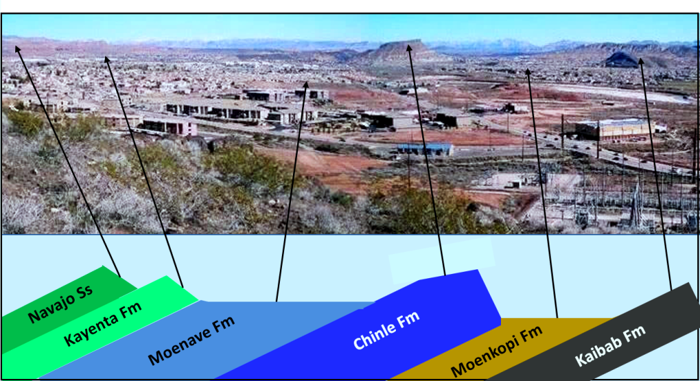
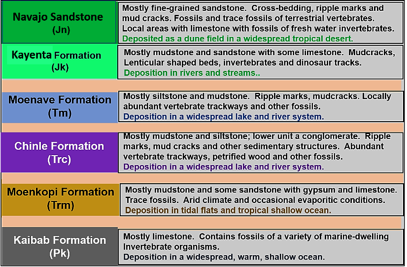
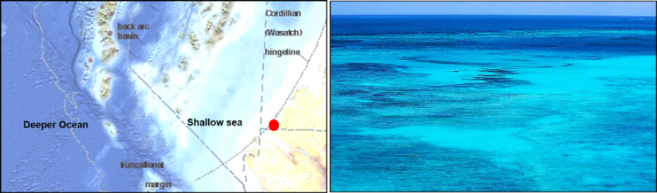
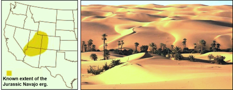
Each of the sedimentary rock formations exposed in St. George was formed in an ancient depositional environment. Over the approximately 90 million years represented by these rocks (see Figure 2), depositional environments changed rather dramatically, ranging from a tropical ocean to terrestrial lake and river systems to an extensive tropical desert that consisted of sand dunes and occasional freshwater oases (Figure 5).
These changes were the result of a westward and northward movement of what is known as the North American Plate. This movement occurred from the breakup of a supercontinent called Pangaea and the beginning of the formation of the Atlantic Ocean, a process which began about 180–190 million years ago.
Bloomington Hills area along River Road By Little Valley, approximately half a mile past the turn to Little Valley (Horseman’s Park Drive on east side of road)
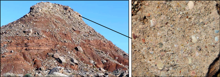
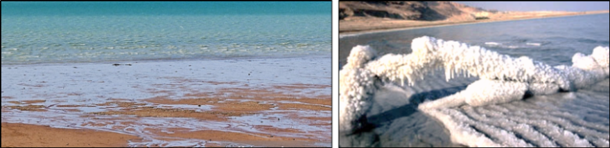
At this location, locally known as Fossil Ridge or Fossil Hill, exposed light gray-brown rocks are named the Kaibab Formation. This is the same formation that occurs as the top layer of rocks at both rims of the Grand Canyon. In our area, the Kaibab is mostly a fossiliferous limestone that consists of the mineral calcite (calcium carbonate). These rocks formed as sediments deposited in an ancient, widespread ocean, which covered this region during a portion of the Permian Period, about 270 million years ago (Figure 6).
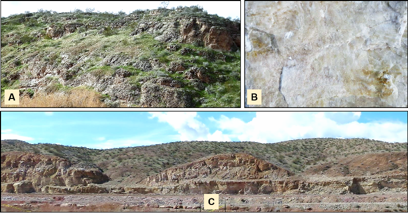
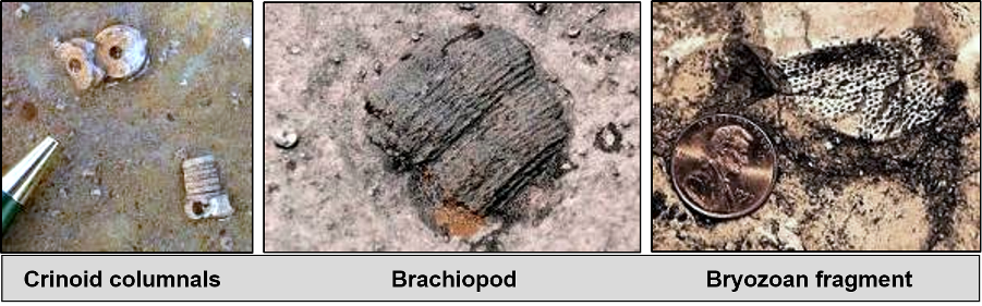
In this area, the Kaibab Formation has poorly preserved but relatively common fossils, some of which are illustrated below. If you climb partway up the hillside and look at fragments of the limestone closely, it is likely that you will see some of these fossils. Some are small or only fragments, so a magnifying glass will help you to see details (Figure 7).
Note: A new subdivision is being built up along this area of River Road and prevents access to most of the Kaibab fossil hill location. The best spot to gain access is from the parking lot of the Dixie Power Building, but only on weekends.
Extensive geological research on the distribution of the Kaibab Formation has provided evidence that it has a widespread geographic extent in the southwestern US. Using this known distribution, geologists can reconstruct what the region may have looked like in Permian time (Figure 8).
A paleogeographic map represents a time interval when a particular rock formation such as the Kaibab sediments were originally being deposited. Maps like this are made from compilations of data obtained from numerous studies of the rocks and fossils of a region and interpretation of how they were formed. Think of this as a map Rand & McNally would have made if they had been around 270 or so million years ago during Permian time!
If you climb up the hillside and look to the west and northwest, you will see much of the geology and geography of the west side of St. George (Figure 9). If you look at some of the ridges, you should be able to see that the layers of rocks are tilted downward towards the north (geologically they dip north). Therefore, as you look northwest towards Pine Valley Mountain, the exposed sedimentary rocks become geologically younger. The topographic features in this area, hills and valleys, are the result of weathering and erosion, which differentially affects the layers of rocks. More resistant rocks form the hills and ridges whereas less resistant rocks weather and erode more easily and become the low-lying valleys.
Getting back into town: Dinosaur Museum and Foremaster Ridge
Getting to the museum is only part of the fun. From fossil hill, driving north on River Road, you will see this view (Figures 10 and 11).
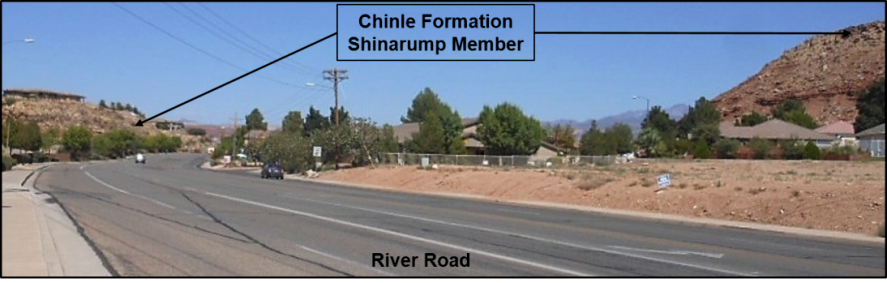
As you continue to drive past the ridge of Shinarump, look at the numerous boulders of the Shinarump, which have come down from the ridge top. These blocks represent a type of mass movement called rock fall (Figure 12).
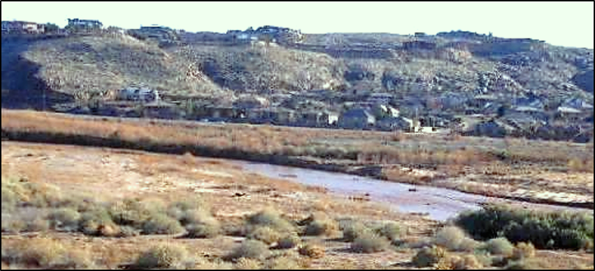
Continue traveling on River Road and cross the bridge over the Virgin River (the river flood plain can be view from the bridge). Turn right on Riverside Drive. On your right is the Virgin River in its flood plain. On your left is the south end of Foremaster Ridge, where the lava that forms the ridge top stopped flowing. Drive approximately half a mile and pull over onto the dirt shoulder. Be careful as the speed limit is 40 and most everyone drives faster than that!
Across the Virgin River Valley is the ridge that makes the location for Stone Cliff Estates. The ridge is there because of the resistant layer of Shinarump Conglomerate that forms the top. If you look closely, you can see rock retaining walls on many of the homes (Figure 13). As far as I know, the rocks are carefully fit on top of one another but are not anchored or cemented. During the next modest earthquake in St. George, I expect many of them to fall down. If you have a camera, consider taking a “before” picture!
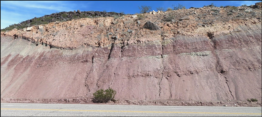
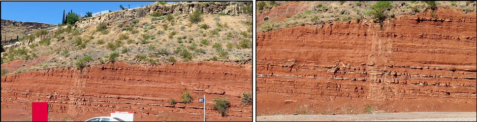
On the left side of the road are road cut exposures of the Petrified Forest Member (upper unit of the Chinle Formation), which lies above the Shinarump Conglomerate. Notice the grayish purple color of the rocks, and the poorly defined layering of the exposures. This is the infamous blue clay of St. George (Figure 14).
This is the same rock unit that occurs at Petrified Forest National Park in Arizona, although there are not as many petrified logs in this area.
After being up close and personal with the blue clay, continue along Riverside Drive to the intersection with Foremaster Drive. Turn right to the Dinosaur Discovery Museum at 2180 E. Riverside Dr., or turn left up the hill for a slight detour.
Scenic view: Optional stop on Foremaster Ridge
If you make a left turn onto Foremaster Drive, drive up the hill to the crest and turn right on Five Sisters Drive. You can continue along Five Sisters or turn left onto Crestline Drive. The goal here is to find a vacant lot from which to view the geology looking northeast (see Figure 3). Many of the rock formations can be seen from this area. A good landmark is Shnabkaib Knob (Figure 15).
The Moenkopi Formation was deposited under hot and dry conditions within shallow marine and mudflat environments (Figure 16). The mineral gypsum (calcium sulfate) precipitated out of solution and forms thin veins within the formation. It is this gypsum in the Moenkopi, which will dissolve in water, that generated the failure of the Quail Creek Dam in 1989.
If you took the side trip up to Foremaster ridge, return back to Riverside Drive and turn left to the Dinosaur Discovery Museum. This museum was built on the Moenave Formation, which overlies the Chinle Formation but weathers easily and is not well exposed.
Johnson Farm Dinosaur Discovery Site & Museum: A world-class fossil location
Dinosaur tracks were discovered here accidentally during excavation of the property in 2000. Recognizing that these tracks were very significant from geologic and paleontologic perspectives, Dr. Sheldon Johnson and his wife Laverne donated their property to the City of St. George. The location has been developed into a world-class paleontological site. A variety of sedimentary structures, trackways, and other fossils are preserved in the Early Jurassic age (approximately 199 million year old) sandstone and siltstone of the Moenave Formation (Figure 17). Based on various types of fossils and sedimentary features, the Moenave is interpreted to have formed in widespread warm and humid river and lake environments. A model for this is displayed at the museum.
A recent publication by Jerald D. Harris and Andrew R. C. Milner is “Tracks in Deep Time.” This well done book provides an easily readable account of the site and its significance. It is available for sale in the museum gift area.
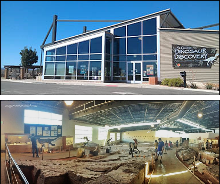
Take a tour of the museum. Lots to see for a very nominal fee. Weekdays are a great time to visit as there are usually only a few people there. View the short video, which tells the story of the museum. Then check out the specimens and various displays. This has actually turned out to be a paleontologically significant location, right here in St. George!
Also, be sure to note a diorama of what is termed Lake Dixie, which existed in this area during Late Triassic-Early Jurassic time.
Something to ponder when at the museum is that these numerous, well exposed trackways are the graphic evidence of living, breathing creatures from the past that were doing their thing right where you are standing … but nearly 200 million years ago. Along with the preserved trackways, there is even an impression in the rocks of a sitting dinosaur — literally a butt print in the sands of time!
These and other various dinosaurs that existed for around 160 million years of the Earth’s history were a very diverse group of organisms and occupied land, sea, and aerial environments. Except for birds, they all became extinct about 65 million years ago. Even on a large scale, life is fleeting.
East side of Middleton Black Ridge: Evidence of a missing rock record and a geologic hazard
After leaving the museum (if you can manage to finally leave!), drive back on Foremaster Drive to Mall Drive. Turn right and travel about 0.7 miles north to 40 North. Turn left into the Foxborough Development. The road becomes 1680 E. Travel 0.2 miles. Park on the side or off the road, and observe the ridge. There are some red dirt pullout areas on the west side of the road next to Middleton Creek.
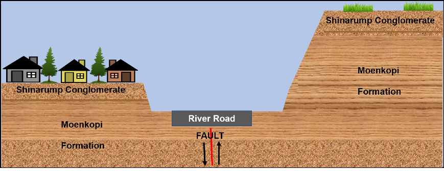
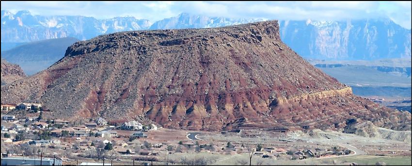
Rocks exposed on the east side of Middleton Black Ridge (Figure 18) include the basalt flow and conglomerate seen in Figure 14. However, the underlying rocks here are the tilted Kayenta Formation. The conglomerate layer provided the large 12×9 foot boulder that rolled down the hill and crashed into a home in January 2013 (another rock fall). The contact between the Kayenta Formation and the overlying conglomerate represents an angular unconformity and is discussed below.
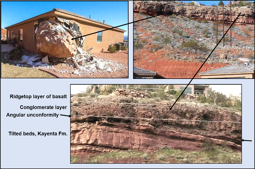
The rocks exposed here provide an interesting story, which is best viewed in the earlier part of the day when the sun is still in the east. The lowest unit is the Kayenta Formation, one of the “red rock” units common in southern Utah. It is of Early Jurassic age (~190 million years old) and consists of sandstone, siltstone, and shale, which were deposited in a widespread floodplain/stream environment. The overlying rocks are a layer of conglomerate and a layer of basalt, which caps the ridge. These two layers are considerably younger than the Kayenta and are less than 2 million years old. The conglomerate was formed in a stream/river valley and was covered by the lava flow.
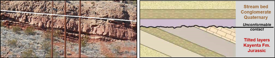
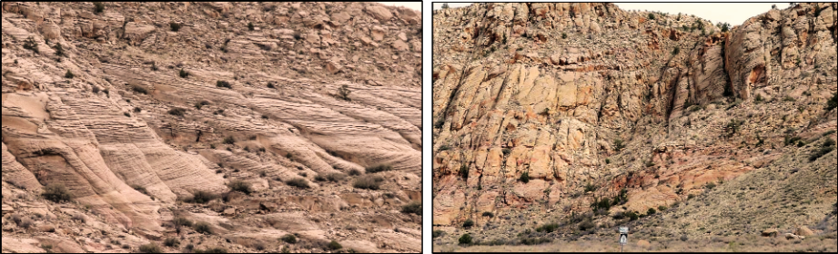
The contact between the Kayenta and overlying conglomerate is called an unconformity, and in this example, more specifically, an angular unconformity. If you look closely, you should be able to see that the conglomerate cuts across the tops of tilted layers of the Kayenta (Figure 19). At this location, about 190 million years of geologic time is represented by the unconformable contact, and there are no rocks here representing that interval.
One further observation you can make at this stop is the Middleton Black Ridge basalt lava flow farther up 1680 E (Figure 20).
Getting out of town
Continue on 1680 E to Red Cliffs Drive. You will pass the “World Famous Red Cliffs Mall.” Turn left on Red Cliffs and go to St. George Boulevard. Turn right on St. George Boulevard to 1000 E at the corner with a Maverick station. Turn right on 1000 E and go up the hill to Red Hills Parkway. Turn left on the parkway and travel westward to Bluff Street (State Route 18). Turn right on Hwy 18 and proceed north.
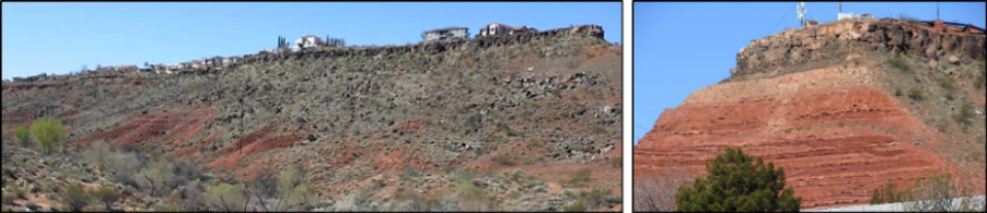
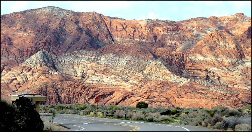
The drive along Red Hills Parkway provides some excellent views of red rocks, in particular the Kayenta Formation and overlying Navajo Sandstone (Figure 21).
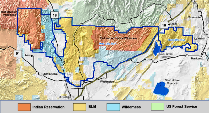
Red Hills Parkway approximately marks the southern boundary of a portion of the Red Cliffs National Conservation Area, which was established in 2009 and currently covers approximately 45,000 acres (Figure 22). This conservation area protects many indigenous plants and animals. Numerous hiking trails can be found in the area. Information and maps are available at the headquarters building on 100 E at the corner of Tabernacle or at the St. George Field Office of the BLM at 345 E. Riverside Dr.
As you travel along Red Hills Parkway and then State Route 18, the landscape is dominated by red rocks and dark gray to black basalt lava flows. Contemplating the red rocks, here are some thoughts to consider (Table 1).

Diamond Valley turn off: Evidence of volcanism
Drive north on State Route 18 past the Ledges and Snow Canyon State Park until you reach the Diamond Valley turn off. There is space to part at the side of the road. At this location, there are two cinder cones, one north of the turn off and one right at the turn off, and a basalt lava flow (Figure 23).
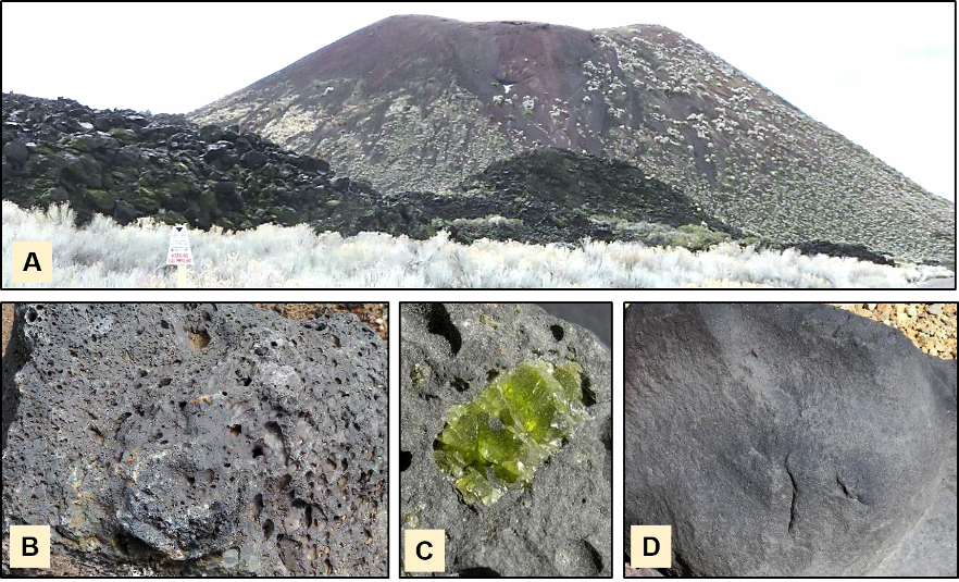
Numerous cinder cones and lava flows occur in St. George and surrounding areas, including the three distinct lava ridges within the city. Based on radiometric dates, all of these volcanic features are geologically young and have formed within the past 2.5 million years of geologic time.
North end of Snow Canyon State Park: Remnants of an ancient desert
Return south on State Hwy 18 to the north entrance to Snow Canyon. There is a small parking lot just outside the entrance station next to the highway, which is a good place to park. From this spot, there are a number of features to see in the Navajo Sandstone, which is the youngest rock in our stratigraphic column. Best time to see these features is early afternoon.
The Navajo Sandstone, along with a couple of other formations of the same geologic age at other locations all represent the preserved remnants of an ancient desert of widespread sand deposits. This desert existed about 190–180 million years ago and covered many states in the southwest (Figure 24).
Also at this location are a number of distinct features within the Navajo Sandstone (Figures 25 and 26).
At this point you can continue north on Hwy. 18 to the Veyo Pie Shop, drive through Snow Canyon and view the beauty of the park, or return south on Hwy 18 and merge onto Bluff Street. Head south on Bluff towards Interstate 15. The stop on south Bluff Street provides an example of what may happen to structures when built on the blue clay of the Chinle Formation.
North and South Bluff Street: The Kayenta Formation and blue clay of the Chinle Formation
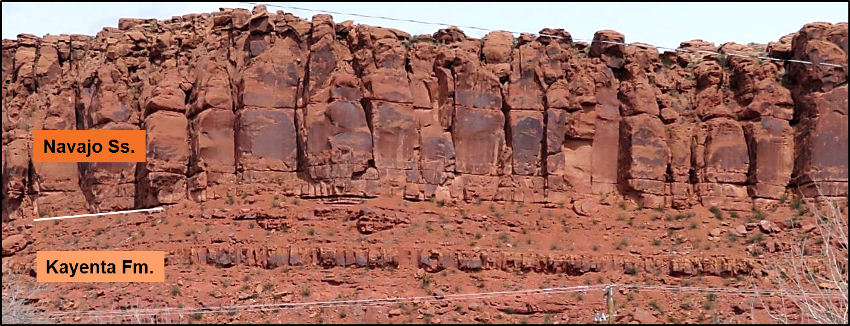
Traveling on Bluff Street south of Sunset at approximately to 300 N. Bluff St., there is an excellent new excavated exposure of bright red, well bedded Kayenta Formation on the west side of the street (Figure 27). If you pull into the vacant lot at the base of the hill, you can examine the formation.
For the last stop on this trip, continue south on Bluff Street. At about 1100 S. Bluff St., observe the ridge slope on the west side where a row of condominiums was built in the early 2000s. In 2011, the blue clay below the ridge expanded and shifted, resulting in significant damage to structures. Two condo units on the hillside were directly affected along with the street-level Dairy Queen and Knights Inn Motel, both of which are gone (Figure 28).

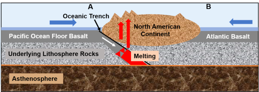
A geologic explanation for our wonderland
The following two figures provide an explanation of why St. George has all these geologic features (Figures 29 and 30).
Articles related to “Our Geological Wonderland: A self-guided field trip in and around St. George”
Our Geological Wonderland: Examining the Biblical Great Flood
Our Geological Wonderland: The missing rock record in St. George


What a wonderful article! Thank you so much for printing it. It has such interesting information that is understandable with great photos and illustrations. My compliments to all involved.
Thank you, thank you! This is truly a public service to all of us in the St. George area.
Excellent information presented in a most interesting style and a very colorful format. As a resident or a visitor, it helps reminds us about this special place.