
 Hiking Southern Utah: The East Rim Trail

Written by Bo Beck & Tanya Milligan
SEE NOTICE BELOW FOR TRAIL UPDATES
Day hike: Yes, but it can also be done, and is often enjoyed, like a backpack.
Distance: 10 miles one way with the use of a shuttle or by hitchhiking, which is allowed within Zion’s boundaries. It is a 20-mile round-trip without a shuttle.
Average hiking time: Plan for a six-hour hike from the trailhead at the east entrance to the trail end at the Weeping Rock parking lot.
Difficulty: Strenuous for a maintained and classic Zion National Park trail.
Sun exposure: Full sun on most of the hike, but the start is a somewhat strenuous and sandy uphill slog with little shade. Bring plenty of water and begin hiking early in the day.
Permits: These are not needed for a day hike, but if you plan to backpack, an overnight camping permit is required.
Water availability: Stave Spring is an unreliable water source, and water from it must be treated before drinking. During wet years, there is an intermittent waterfall at Jolly Gulch.
Trailhead: 150 yards west of the east entrance.
Trail-End: Weeping Rock parking lot.
Trail access: Usually, this trail is okay to hike from late March until early November, depending on snow and ice conditions.
Elevation gain: 1,400 feet with a moderate steady climb and then a gradually steepening downhill descent of 2,400 feet.
Peak: 6,700 feet
Dog-friendly: No
⚠️Due to major rockfall, this trail does not connect with any trails in Zion Canyon.
However, other aspects of the trials mentioned below are accessible from other locations.
Please visit NPS.Gov to learn more about these trails.
To Access This Hike You Must Start From The East Entrance Trailhead From Zion-Mount Carmel Highway.
East Rim Trail
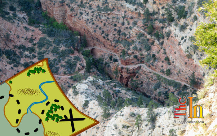
The East Rim Trail is said to be one of the most scenic, in all of Zion National Park, and is on many lists as one of the best hikes in Utah. With all the classic trail competition in Utah, like the Zion Narrows and Angels Landing, that is saying a great deal. This hike begins with a backdoor view of Checkerboard Mesa as it skirts Clear Creek for a short time and steadily and gently climbs through a juniper and pine forest. On top of the mesa, the scenery gets interesting as a spectacular view of Echo Canyon takes center stage. Echo Canyon is one of Zion’s well-known slot canyons but technical skills, canyoneering gear, and a permit are required to explore its bowels. On the East Rim Trail, however, you will get a peek at it. Throughout much of the rest of the hike, the trail drops into Zion Canyon, where Zion’s landmarks steal the show.
This trek begins on the east side of the park and climbs over 1,400 feet to the rim. Towering pines and the elusive Echo Canyon, an impressive slot, bring a marked change of scenery about midway on this adventure. The downhill finish is spectacular, keeping an almost constant view of some of Zion’s greatest landmarks, including Angels Landing, Organ, Great White Throne, and in the distance is Cathedral Mountain. From the parking lot at the trail’s end, look up to the top of historic Cable Mountain for a great perspective of the mesa the East Rim Trail descends from.
East Rim Trailhead
After positioning a vehicle or making shuttle arrangements, watch for the small “trailhead” sign along the Zion-Mt. Carmel Highway, immediately west of the east entrance booth. From the first section of the hike, the view looking back toward the road frames the geological wonder Checkerboard Mesa. Its deeply etched crossbedding showcases the White Cliffs. Initially, the trail follows the intermittently flowing creek bed of Clear Creek, and the line where BLM land begins will be to the right, as well. The old wagon road trail, Winder Stock Trail, ascends gradually the next 5 miles through junipers, pinyon pines, shrubs, and some small ponderosa pines. Some places are sandy along the trail, but the steady climb to the top of the mesa is a moderate trek.
Jolly Gulch
Jolly Gulch is the first signed area the trail passes and is located 2.8 miles into the hike. It’s a nice view down into a canyon, but when the water is flowing in Jolly Gulch the waterfall is magnificent. Layered rock is evident along much of this section of the trail.
Stave Spring
Continue the uphill climb to Stave Spring. The spring is not much more than a pipe in the ground during years of drought, but during wet years there are streams flowing about Stave Spring. Look for remnants (old posts) leftover from logging. This is the 5.7-mile mark. Another half-mile and there is a sign directing the way to finish the East Rim Trail and giving the mileage for other options at the top of the mesa. The turnoff to Deertrap and Cable Mountain is just past Stave Spring (5.8 miles from the trailhead) and it is signed. Check the NPS site for current conditions on this spring.
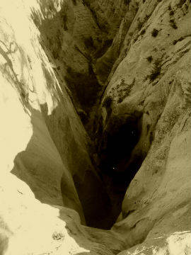
Echo Canyon
With 4.3 miles left in the hike, the East Rim Trail begins to flatten. At the top of the mesa, the scenery gets impressive as the trail edges the incredible Echo Canyon slot canyon. To the west, the immense Cathedral Mountain looms. The view down into Echo Canyon is incredible and the Slickrock of East Zion is abundant here, where patterns on ancient twisted and uplifted sand dunes are seen. A steep descent now begins into what must be one of the most sensational sections of Zion. Once down and inside Echo Canyon, the trail becomes a charming, rock-lined path that winds around towering obstacles. This part of the trail displays the incomparable magnificence of Zion’s geology. Smaller versions of one of Zion’s most well-known landmarks, Checkerboard Mesa, which is seen at the first of the hike, are now visible on smaller crossbedded cliffs. The scenery is impressive as fossilized sand dunes glitter in the sun and giant monoliths are seen in every direction.
Downhill trek on a paved trail
The East Rim and Observation Point Trails now combine with the lower portion of the Observation Point Trail. Less than a half-mile farther is the narrow passageway through Echo Canyon and the charming “Echo Canyon Walkway,” followed by a steady downhill hike into Zion Canyon.
Stave Spring
37 15.672N
112 54.288W
Elevation 6,515 ft.


