
 |
| Photo by Greta Hyland |
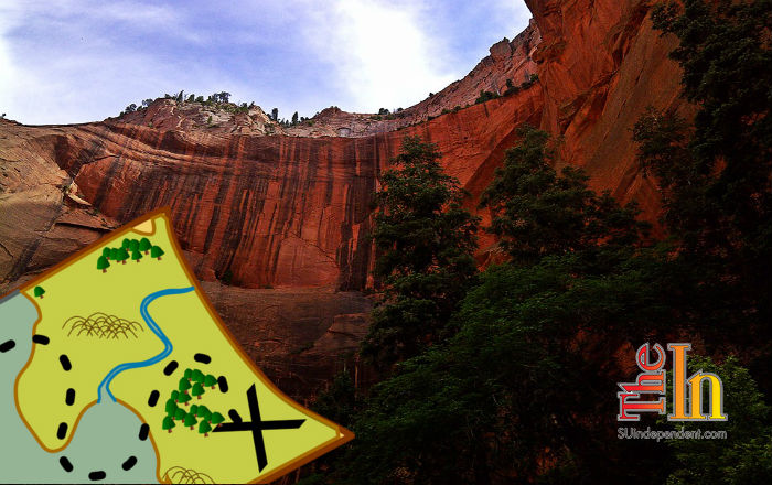
Middle Fork Taylor Creek – Kolob Canyons
Written by Bo Beck & Tayna Milligan
The Kolob Canyons are located in the northwest corner of Zion, accessed off I-15 (exit 40), about 90 minutes from the south entrance of the main section of Zion. This section of the park is also known as the Finger Canyons, a label that is obvious after looking at a topological map of that area. The fingers are tall, orange-colored rock formations with narrow canyons between them. The Finger Canyons of Kolob were formed by the north, middle and south forks of Taylor Creek – all of which can be hiked, but the Middle Fork is the most popular of the three.
MIDDLE FORK TAYLOR CREEK AT A GLANCE
Day Hike: Yes
Trail Distance: 5.4 miles round-trip
Average Hiking Time: 4 hours
Trail Usage: High, this is the most used trail in this section of Zion.
Difficulty: Easy to Moderate. Little elevation change, but it’s a dirt trail with several stream crossings.
Sun Exposure: There is a mixture of sun and shade.
Permits: Not required.
Trail Conditions: Maintained dirt path with shallow but year-round streams that need to be crossed. The path can be muddy after rain or snow.
Trail-head: Two miles past the Kolob Canyons Visitor Center.
Trail-end: Same as trailhead
Trail Access: Year-round.
Best Season: March to November
Off the Beaten Path: No
Classic Zion Hike: Yes
Larsen Cabin: 5,674 feet
Fife Cabin: 5,740
Highest Elevation: 5,950 feet
Restrooms: Kolob Canyons Visitor Center
Water Availability: Taylor Creek is a mostly year-round spring-fed stream.
KOLOB CANYONS
The Kolob Canyons is just a short drive from either St. George or Cedar City – sitting about 18 miles south of Cedar City. If you are driving from the main section of Zion, then it’s about a 38-mile drive from the Zion Canyon Visitor Center going through LaVerkin to Toquerville and onto I-15.
MIDDLE FORK TAYLOR CREEK
The 5.4-mile route begins at the Middle Fork of Taylor Creek Trailhead and ends at the fantastic geological feature Double Arch Alcove. This is considered to be a family hike and is a moderate trek, but it will be too long for most young children. It’s best to start early before the sun heats up sections of the trail that get little shade. The ascent is 450 feet, and the summit is 5,950 feet.
There are a couple of charming historic cabins – the Larsen and Fife Cabins. This hike has one problem, and that is rattlesnakes are common along the path. But if you are not looking for them, you will most likely never know they are there. When Bo and I hiked the trail in April we did not see any snakes, but when I (Tanya) went with my children the year prior in May, we experienced two rattlesnakes in different sections of the hike that were on the trail. The two children that led this hike were face-to-face with a coiled snake rattling its tail. The next snake sighted was when several of us walked right past it without knowing, but the last two kids in the group saw it. It was resting under a log. Later, we read on the brochure that rattlers are common on the hike.
The end of the hike is a shady and ideal place for a good picnic lunch. Be sure to bring plenty of water along on this hike. In April there was dripping water in the alcove, but in May it was bone dry.
Trailhead: Drive 2 miles past the Kolob Canyons Visitor Center and pull into the marked parking area. The Middle Fork of Taylor Creek Trail and the North Fork of Taylor Creek share the same trailhead. Follow the well-marked Middle Fork of Taylor Creek Trail, crossing the stream numerous times. Paria Point is to the right and Tucupit Point is to the left.
Larsen Cabin: The Larsen Cabin is located among a grove of pines and juniper trees 1.2 miles up the trail, a little off the trail on the left. The Larsen homestead cabin was built in 1930 and was lived in by Gustav Larson until 1933. The 1930s cabin marks the confluence of the two forks. Tucupit Point towers above the cabin. To the left of this point is the North Fork of Taylor Creek. The limestone-capped mountain behind Tucupit is Horse Ranch Mountain, the highest point in Zion National Park at 8,726 feet. Beyond the cabin, follow the beaten path along the creek. The path does crisscross back and forth from side to side.
Fife Cabin: SUSC instructor Arthur Fife also built his cabin in 1930. When not at the college in Cedar City, he lived in the cabin and raised goats. This cabin rests in a grove of maple, oak and fir trees. The trail bends to the right after the Fife cabin.
Double Arch Alcove: Continue following the creek bed to where the canyon ends at two blind arches in one rock face. The orange-red color of the cliffs is from hematite, an iron oxide. If you love the wildest of nature then this trail is for you. Besides the snakes on the May hike, we also ran into a tarantula and cougar tracks. There is a lot of vegetation along the path. Red flowers were abundant, such as the bright red penstemon, Indian paintbrush and the skyrocket that are also common in Zion Canyon.
Beyond Double Arch Alcove: There is another alcove about 0.25 miles beyond the main destination that often has a flowing waterfall. There is a landslide up the canyon, but a steep trail leads around the obstacle allowing farther exploration.
Information by Zion search and rescue veteran team member and Desert Rat Outdoor Store manager Bo Beck, as well as www.zionnational-park.com author and owner of the Best Western East Zion Thunderbird Lodge in Mt. Carmel Junction, Tanya Milligan.
Bo Beck and Tanya Milligan’s new book “Favorite Hikes in & Around Zion National Park” is scheduled to hit stores this month. They will present a slideshow and talk on June 28 at Red Mountain Spa, and book signings will be coming up soon. Check www.facebook.com/Zi0nNationalPark for updated details.


