

Our Geological Wonderland
Grand Canyon National Park, Part One
This article and the following articles describe one of the most famous and well-known U.S. national parks. Because it has the oldest exposed rocks compared with Zion and Bryce, following standard geologic procedures, we will discuss the Grand Canyon first. The Canyon provides a chronological record of about 1.8 billion years of the Earth’s history. Additionally, the Canyon also offers spectacular scenic views and is a testament to the slow but unrelenting power of erosion.
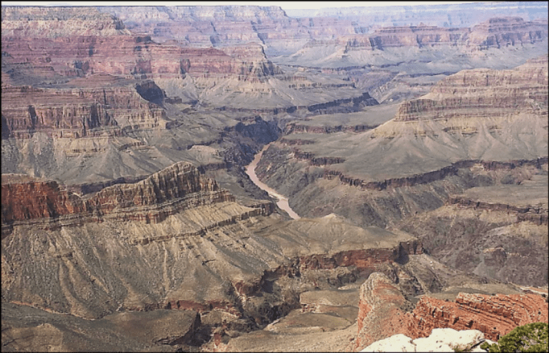
At only about 100 miles southeast of St. George, the Grand Canyon represents one of the natural wonders on Earth’s surface. Some of its statistics according to the Park Service: The Canyon is 277 river miles long, 18 miles across at its widest point, and about one mile deep (Figure 1). Impressive size, but pales in comparison to Valle Marineris on Mars, which is about 2,500 miles long, 120 miles wide, and up to 7 miles deep. Both lose out in size to the East African rift system, which is about 4,000 miles long and averages 30–40 miles wide.
President Theodore Roosevelt gave the Canyon national monument status in 1908. His comment: “In the Grand Canyon, Arizona has a natural wonder which, so far as I know, is in kind absolutely unparalleled throughout the rest of the world.” Subsequently, President Woodrow Wilson signed a Congressional Bill establishing the Canyon as a national park in 1919.
Discovery and Exploration
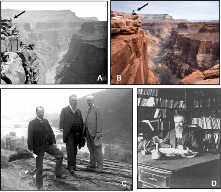
Just a few years after the Civil War, war veteran Major John Wesley Powell, although missing much of his right arm, led the first scientific expedition through unexplored territory out west, including what he termed “a grand canyon.” His group of 10 men, using four boats loaded with supplies, began their exploratory journey at what is now Green River, Wyoming, in May 1869. They finished about four months later with only three boats and seven men 900 miles away at St. Thomas, Nevada (now covered by Lake Mead) in August 1869. This first and subsequent exploratory trips provided the impetus, eventually leading to the Canyon’s designation as a national monument and then a national park. (Figure 2).
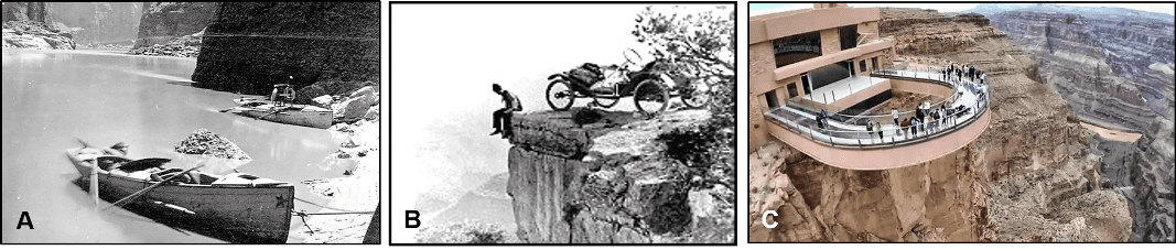
Since its exploration by the Powell expeditions over 150 years ago, the Grand Canyon has provided geologists with a variety of features to observe and study. These features illustrate some of the major underlying concepts of the earth sciences. It is a spectacular place to learn about geology. Over the years, the Canyon has been visited and studied in many ways. Of course, an added perk is its scenic beauty that currently attracts over 5 million visitors per year (Figure 3).
Geological Studies of the Canyon
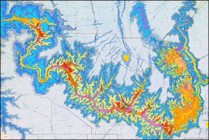
Basic geologic procedures when first studying a new location are to recognize, map, and provide formal names for different layers of rocks. Such geologic maps show the surface locations of rock formations (Figure 4). Formation names are usually based on either the physical characteristics of the rocks (Tapeats Sandstone) or on a geographic location where the rocks were first studied (Toroweap Formation). Each formation is formally named when first published in a peer-reviewed publication.
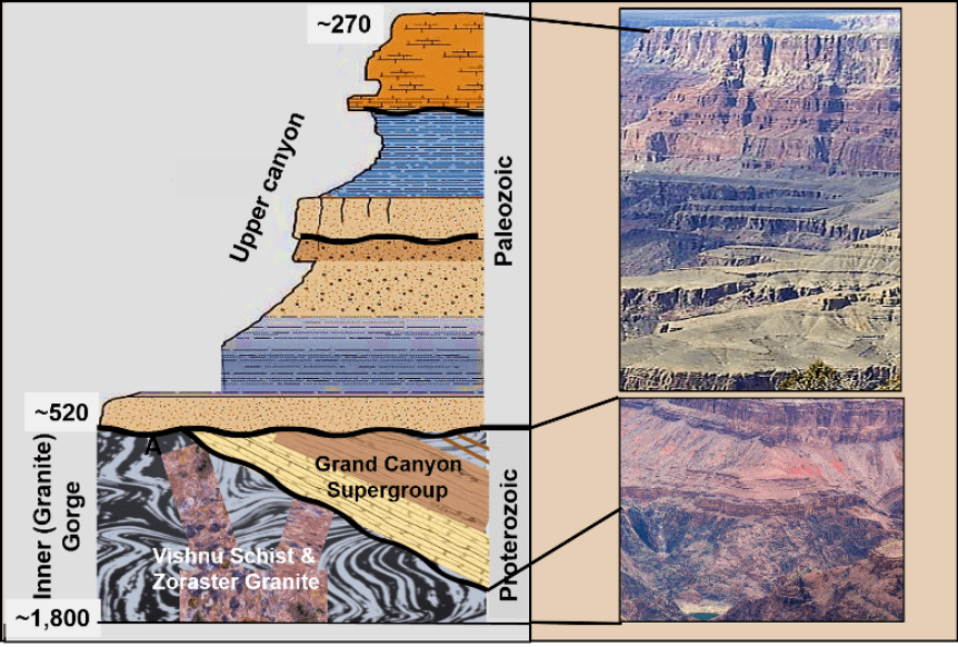
Rocks at the Grand Canyon can be divided into three main packages based on their geologic ages (National Park Services uses the term “sets”): (1) Oldest is the Vishnu Schist/Zoraster Granite; (2) Overlying that is the Grand Canyon Supergroup; and (3) Youngest is a succession of Paleozoic sedimentary rocks. Rocks at the Canyon have received significant study since the Powell Expeditions in 1869; this has resulted in establishing many different formation names. More detailed reviews have provided a chronologic story of a long and complicated geologic history for the southwestern portion of the U.S., and also a recognition that a significant part of this history has been washed away by erosion (Figure 5).
Another basic geologic concept is to categorize differences among these various types of rocks. Students in beginning geology classes learn about the rock cycle that operates on and within the Earth. They become familiar with three main rock groups, igneous, sedimentary, and metamorphic. All three types occur at the Grand Canyon (Figure 6). As noted in a previous article, the processes and the rocks that form result from energy sources, nuclear fusion, and nuclear fission.

The Inner Gorge:
Vishnu Schist, Zoraster Granite and a Supercontinent
The geologic ages of various rocks and other evidence preserved in the Inner (Granite) Gorge of the Grand Canyon years ago, and has continued are summarized in Figure 7.
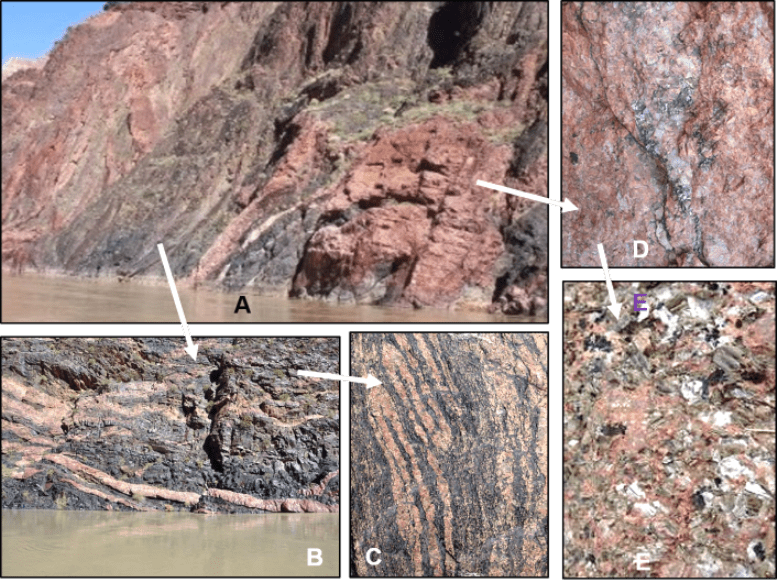
Rocks exposed in the walls of the Inner (“Granite”) Gorge include two main packages (sets). Oldest is the crystalline metamorphic and igneous rocks of Vishnu Schist and Zoraster Granite (Figure 8). The age of these crystalline rocks has been determined by radiometric dating. Understanding the formation and history of these rocks illustrates a complex series of events that occurred in this region over 1.5 billion years ago.
The other package includes overlying and younger sedimentary and volcanic rocks of the Grand Canyon Supergroup, and they will be the topic of the next article.
The Vishnu Schist and Zoraster Granite are crystalline rocks that have a similar chemical composition. However, because they formed under different physical conditions, they have a very different physical texture (see Figure 6, Rock Cycle). Vishnu Schist metamorphic rocks actually represent older sedimentary rocks that were altered by high heat and pressure. Their crystalline texture has a distinct linear orientation that resulted from these conditions. In contrast, the igneous Zoraster Granite formed from molten magma that intruded into and metamorphosed the older Vishnu sediments. As the magma cooled, crystals formed but do not show any linear orientation.
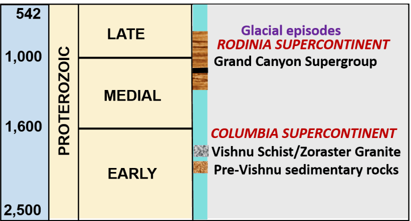
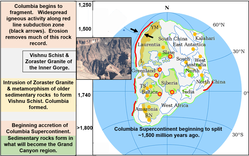
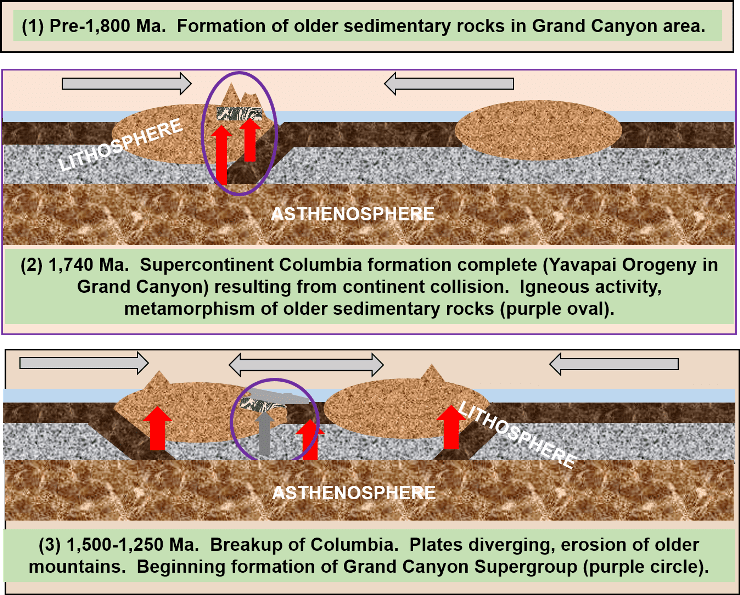
The Vishnu Schist is considered the oldest rock in the Canyon. It initially formed as layers of sedimentary and volcanic (basaltic) rocks before 1,800 million years ago during Early Proterozoic time. These rocks were metamorphosized and incorporated into a supercontinent called Columbia, about 1,740 million years ago. This tine framework correlates with the intrusion of the Zoraster Granite (Figure 9). Columbia existed for perhaps 400 million years but began to fragment between1,500-1,300 million years ago
Radiometric age dates for these metamorphic and igneous rocks are based on measuring ratios of Uranium-Lead or Potassium-Argon preserved within the rocks. Dates have been established by repeated experiments. Although both rocks have similar radiometric ages, the age determined for the Vishnu Schist is when it was metamorphosed from its older sedimentary origins.
A more recent example illustrates what can happen during the formation of a supercontinent. This example is the still existing Appalachian Mountains in North America and the Caledonian Mountains in northern Europe. These mountains formed during the accretion of a much younger supercontinent called Pangaea between 480-280 million years ago and contain metamorphic and igneous rocks that have been used to determine the age of this event (Figure 10).
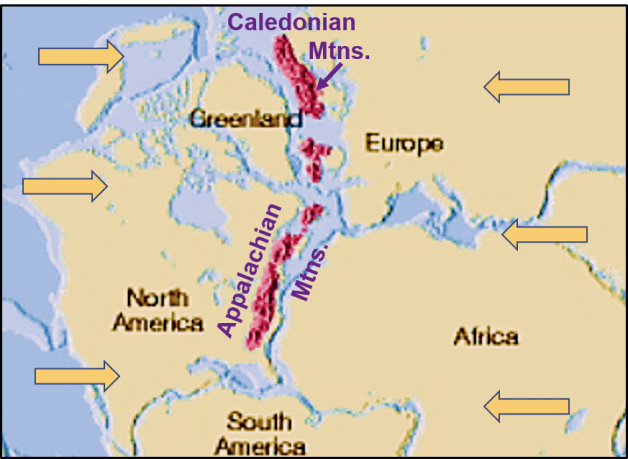
At about 1,500 million years ago, Columbia began to fragment. Literally hundreds of millions of years of erosion occurred, leaving behind only igneous and metamorphic rocks that made up the cores of ancient mountains that existed on Columbia. This brings to mind lyrics from Bob Dylan’s classic 1962 song, Blowin’ in the Wind; “…how many years can a mountain exist before it’s washed to the sea?” We see these remaining rocks today in places such as the Grand Canyon.
A similar situation is again provided by the younger Pangaea, which began to fragment about 190 million years ago, and that event has continued to the present time. Because this is a much younger geologic event, erosion has not completed its job of wearing the Appalachian and Caledonian mountains down to their crystalline cores.
So, ancient rocks exposed in the Inner Gorge represent the roots of ancient Columbia mountains. The erosion surface that resulted following the breakup of Columbia was then covered by ocean waters, and a thick succession of younger sediments was deposited on this erosion surface, which is now recognized as a nonconformity. These younger mostly sedimentary (and some volcanic) rocks are named the Grand Canyon Supergroup (Figure 11). In the following article, a geologic history of the Grand Canyon Supergroup will be explored
Read Part 2 of this series here


