


Our Geological Wonderland: The missing rock record in St. George
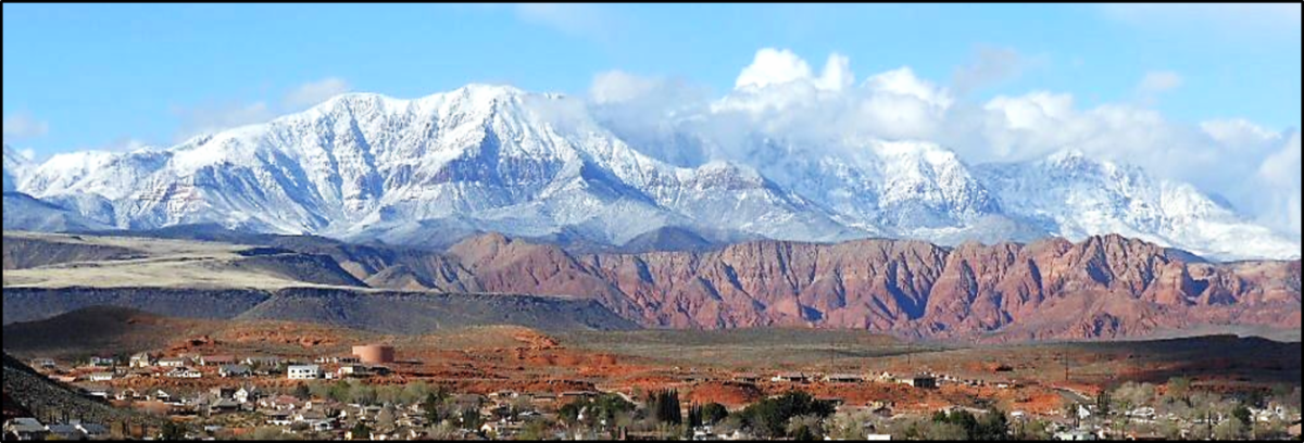
As previously described in a series of 14 articles published in the Independent over the past year, St. George has quite a few unusual and even world-class geologic features. Some of these features are illustrated below (Figure 1), and they indicate why the St. George area is indeed a geological wonderland. This article will discuss only the sedimentary rocks in this area.
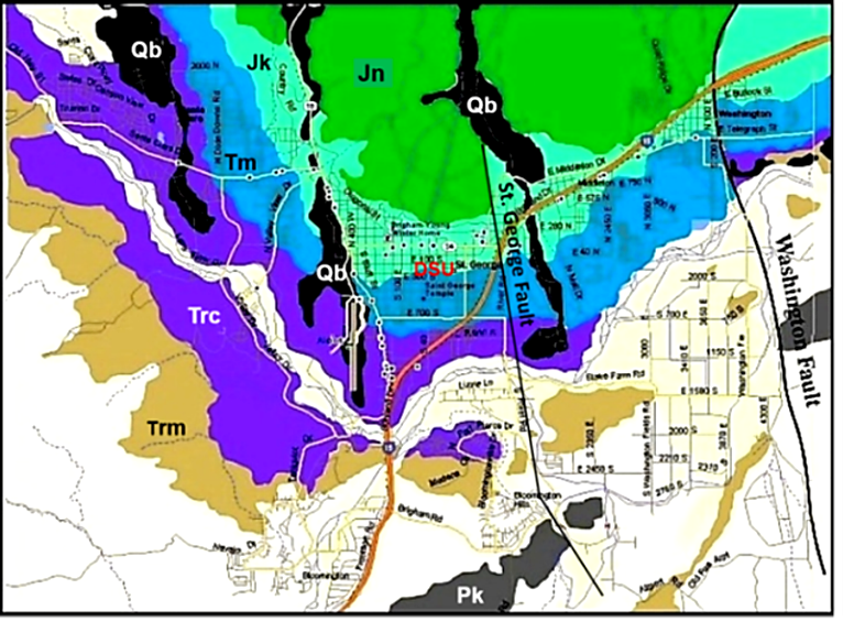
A geologic map illustrates the various rock formations that represent many of the wonderland features seen in St. George (Figure 2). The map below covers only the main portion of the city. Much more detailed published maps by the Utah and U. S. Geological Surveys cover Washington County and most of the United States.
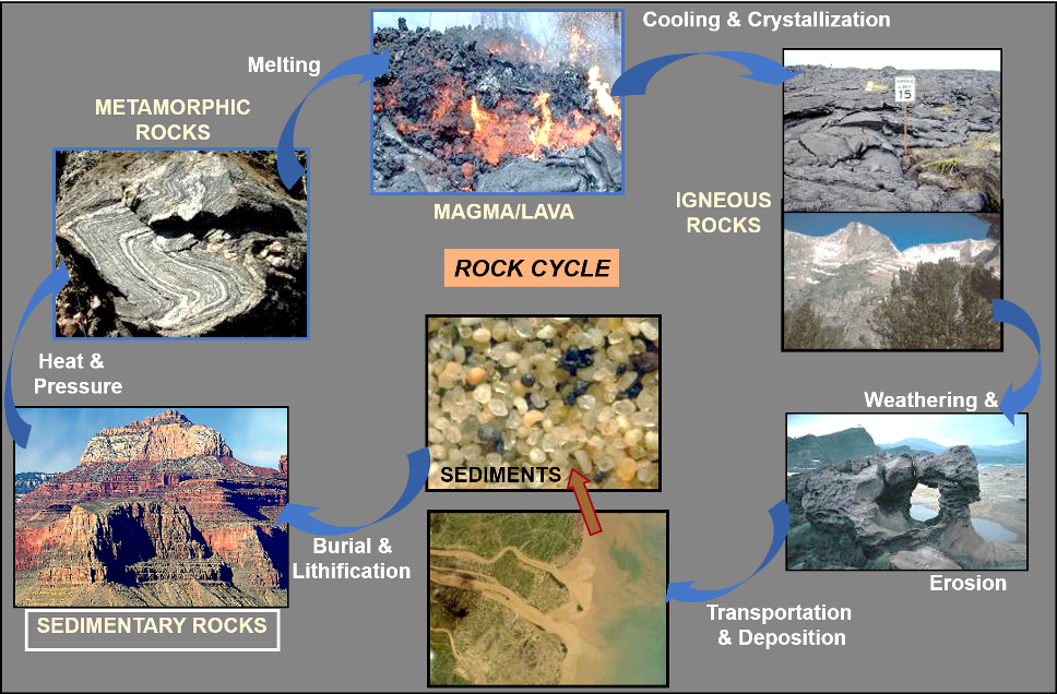
The presence of a sedimentary rock record in our local St. George area and elsewhere provides evidence of how the Earth works. This is illustrated by what is called the rock cycle (Figure 3). Existence of this cycle provides proof for the existence of an atmosphere, hydrosphere, and lithosphere, which are necessary for the existence of life as we know it.
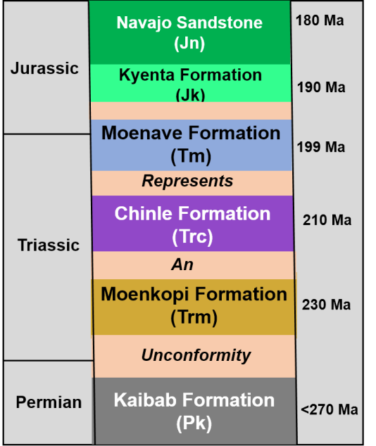
In our area, sedimentary rocks represent approximately 90 million years of geologic time, spanning from about 270 to 180 million years ago. However, this rock record is not continuous. During this 90-million-year portion of geologic time, the local rock record is incomplete. Even though the rocks themselves are nicely stacked on top of one another, in actuality there are intervals of time for which we have a preserved rock record but also intervals of this time for which we have no rock record in St. George (Figure 4). Intervals with no rock record are called unconformities.
This stratigraphic column indicates that the oldest rock formation in St. George is the Kaibab Formation, which contains fossils and was deposited in a widespread ocean about 270 million years ago. The youngest rock formation is the Navajo Sandstone, which was deposited in a large desert about 180 million years ago. Both of these formations, along with others in the column, are widespread in the southwestern United States. Some, like the Kayenta and Navajo, are often seen exposed in spectacular fashion at the numerous national and state parks in the region.
Of note is that all of these formations contain some evidence of past life, including actual body fossils and various types of trace fossils such as burrows and trackways. An example is provided by the Dinosaur Discovery Museum at which world-class trackways are preserved in the Moenave Formation. From this paleontological perspective, the last 30 million years (Late Triassic – Early Jurassic) of this time in various parts of the world represents the appearance of the first dinosaurs, the first true mammals, and the first birds. So far, dinosaur bones and their preserved trackways represent the only one of the three groups to have left an abundant fossil record in our local area,
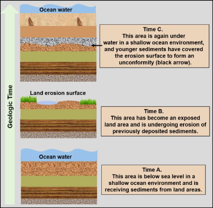
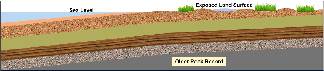
Intervals for which there is no rock record are called unconformities, and in this area, they occur between most of the formations as indicated by the orange intervals demarking the boundaries between formations in Figure 4. A way to think of an unconformity is to consider a story book in which someone has cut out and removed pages, which is annoying if you are trying to read a complete story. Since the early 1800s, geologists have recognized various types of unconformities and how they have formed. In our area, most of the unconformities are of a type called a disconformity (Figure 5).
Length of time an area is exposed to erosion on land will determine how much of the previously formed rock record is destroyed. Some unconformities are known to represent significant lengths of geologic time, in some examples many tens of millions of years or more.
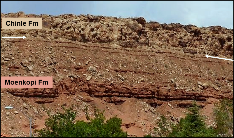
As noted above in Figure 4, there are recognized unconformities in the rock record of St. George between most of the formations. A nicely exposed example of such an unconformity occurs between the Moenkopi Formation and the overlying basal member of the Chinle Formation, which is known as the Shinarump Conglomerate (Figure 6).
A different situation is seen in the transition from the Kayenta Formation to the overlying Navajo Sandstone. In this example, there is a continuous record of deposition, and no unconformity has been recognized (Figure 7). What is evident is that a change in depositional environment affected the type of sediments being deposited, but there is no evidence for erosion. The Kayenta rocks are fine-grained mudstones and siltstones, whereas the Navajo rocks are fine-grained sandstone.

Anatomy of an unconformity
Some types of unconformities record major geologic events such as mountain building, igneous activity, and various structural events like folding and faulting. A good example of such an unconformity is provided by the “Great Unconformity” in the inner gorge of the Grand Canyon. In contrast, disconformities are most common in regions which are geologically stable. This was the situation in the St. George area for most of the 90-million-year interval we are discussing.
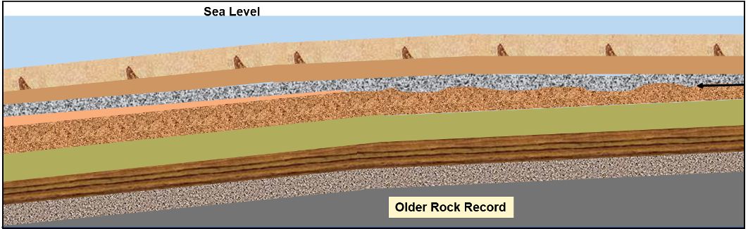
However, to form a disconformity changes in sea level over time are required, which results in lateral movement of shore lines. Think about modern tidal changes. If you are at the beach and set out your stuff near the water, you may find that after a few hours the water has encroached up the beach and may inundate your stuff if you don’t move it. This is a result of ocean tides, where water migrates in and out across the beach during the course of the day.
When the tide is out, the beach sand area is wider. When the tide comes in, the beach sand area is narrower. Project this type of change over a large interval of time and a corresponding change in position of the shoreline covering tens or hundreds of miles. This change is not due to tides but rather is the result of changes in the volume, or global level, of ocean water. An example would be the formation or melting of large continental ice sheets.
The U. S. Geological Survey estimates that if all current ice sheets melted, global sea level would rise over 250 feet above its present level. That would certainly create havoc with our coastal cities and much of the Gulf Coastal Plains.
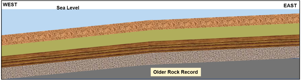
Closer to home, geologists have recognized that during Permian and Triassic Periods and for part of Jurassic time (270–180 million years), much of what is now the southwestern United States was relatively flat and of low elevation above sea level. Therefore, relatively small changes in sea level would either expose or cover much of this region. Also, even slight changes in elevation of the land surfaces would have the same effect on position of the shoreline. The result of such changes would be relatively thin successions of rocks and numerous disconformities. This is what we see in the rock record of the region, and the process of formation can be illustrated with simple cross-section diagrams (Figures 8, 9, and 10).
It is recognized that the sedimentary rock record of St. George represents only a portion of the time between 270–180 million years ago. Disconformities represent the rest of this interval. Another subject to consider is the types of depositional environments that existed and the kinds of organisms that were present during this interval of time and which have been found and studied.
Thanks to Dr. Rob Kramer, Robert Kerr, and Smilla Bithell for reviewing this article and providing some helpful suggestions for improvement.
Articles related to “Our Geological Wonderland: The missing rock record in St. George”
Our Geological Wonderland: An ancient seaway, right here in St. George
Our Geological Wonderland: The Virgin River flows through here


very impress with the article I often wander how the land around St George was formed
I was wondering if you could determine why the property that I live on in Bloomington seems to be sinking? As more then just cracks in the driveway but also holes are opening and now large spaces seem to be sinking under the concrete patio. These circumstances seem to follow a pattern of heavy rain activity. This is worrisome to me so any information and or advise would be very much appreciated, thank you in advance.