

Our Geological Wonderland: A record of ancient environments
Rock record in St. George
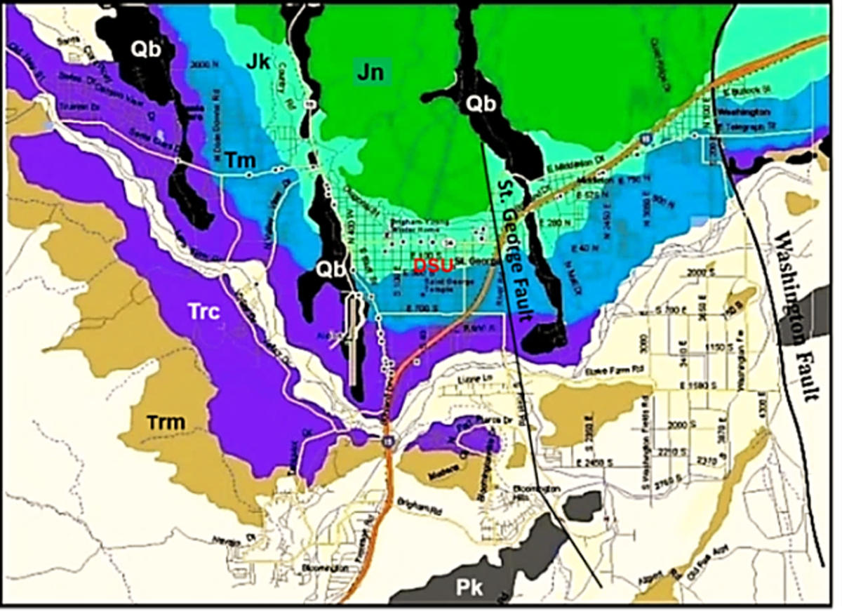
Geologic features in and around St. George are certainly visually stimulating. Many are scientifically significant, and they consist of a variety of different types of rocks of different geologic ages (Figure 1). These rocks are divided into geologic formations. Hidden within each of these formations is evidence of where and how they were formed. Geologists, therefore, hunt for this evidence in a somewhat similar manner by which a crime scene investigator hunts for evidence. Basically, geologists are looking for clues as to the origin and history of each formation.
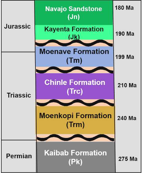
Although these formations are stacked on top of one another in what appears to represent a continuous sequence, there is actually a missing rock record between most of the formations (Figure 2). Think of a story book in which some chapters have been removed. So there are two aspects to consider if the geologic history of these formations is to be determined. First, determine the age and conditions in which each formation was deposited. Second, determine conditions in which each unconformity was formed.
What is an unconformity?
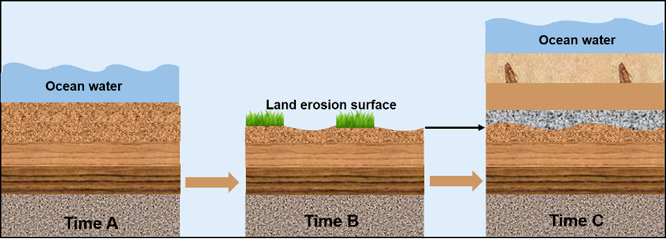
Unconformities represent missing rock record. They occur because of non-deposition, by erosion of previously deposited sediments or rocks, or by a combination of both processes. In St. George, most recognized unconformities are termed “disconformities” (Figure 3). Missing rock record due to an unconformity may represent millions or even hundreds of millions of years of geologic time. Thus, they represent significant episodes within the Earth’s long history.
A geologic history of deposition and erosion
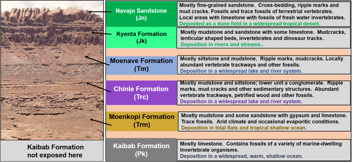
The following discussion will include formations in the St. George area. Each of these formations has been studied in detail by many geologists, some beginning back in the early 1900s, with evidence collected much like a crime scene investigation. The goals in these studies were to determine the type and features preserved in the rocks and to find any fossil evidence and use this information to establish a geologic age and environmental conditions under which each formed. Formation names usually reflect a geographic location where they were first named (like the Kaibab Formation), or the composition of the rocks (such as Navajo Sandstone).
Kaibab Formation
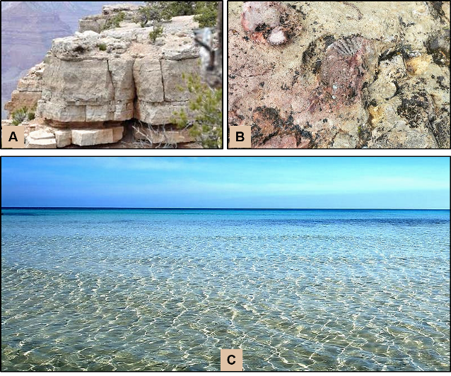
This formation was recognized and named by N. H. Darton in 1910. It consists primarily of limestone (calcium carbonate) and dolostone (calcium/magnesium carbonate). The Kaibab occurs in many areas of the southwest and has a maximum thickness of about 500 feet at the Grand Canyon. In most areas, it is only a few hundred feet thick. A variety of fossils have been found in these rocks, including various invertebrates and microfossils called conodonts. These fossils have been used to establish an Early-Medial Permian age, having been deposited between 283 and 268 million years ago.
The geologic map (Figure 1) indicates that within the St. George area this formation occurs only at the south end of the city and forms low hills along River Road. It represents the oldest rocks exposed in the city. These rocks are light-colored crystalline limestone and contain minor amounts of siliceous chert and scattered fragmentary remains of fossil invertebrates.
Comparison of rocks and fossils of the Kaibab with sediments forming within modern environments indicates that the limy sediments were deposited in relatively shallow ocean water in a subtropical environment, similar to conditions existing today in the Florida Keys and the Bahamas (Figure 4).
Moenkopi Formation
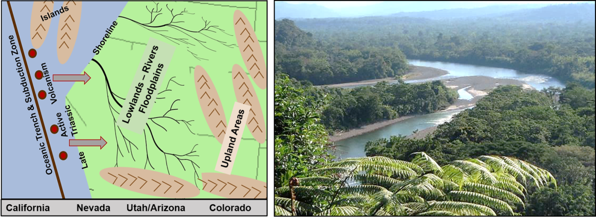
This formation was recognized and named by L. F. Ward in 1901. It consists of a variety of rock types but is predominantly shale and mudstone (Figure 5). This formation is widespread in the southwest and unconformably overlies the Kaibab Formation, but in most areas this contact is covered by sediments eroding from the Moenkopi. It has been divided into at least 14 members in various locations. Sedimentary features such as ripple marks and gypsum occur in the various members of this formation along with a variety of terrestrial and aquatic vertebrate remains and trackways.
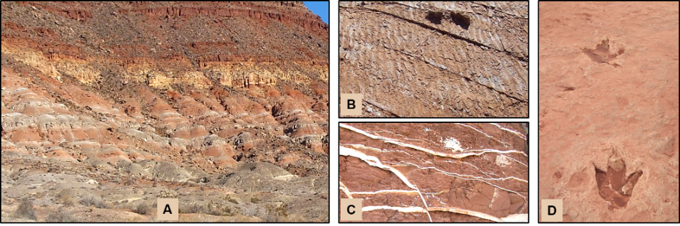
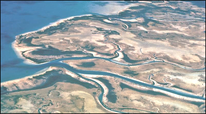
Taken together, these sedimentary and paleontological features indicate that complex depositional environments existed in the region and included freshwater lakes, deltaic floodplains, evaporitic tidal flats, and shallow marine shelf areas in a warm to hot climatic zone (Figure 6).
Chinle Formation
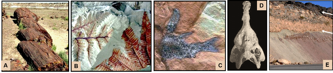
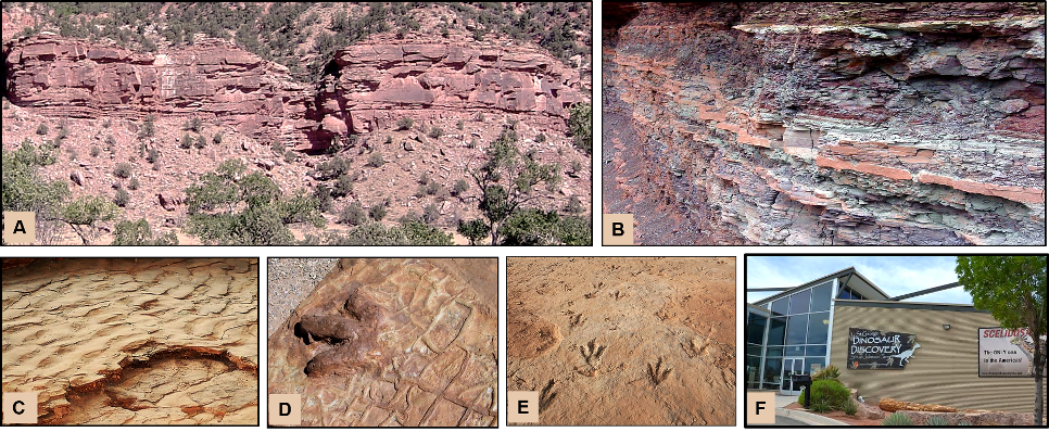
This formation was recognized and named by H. E. Gregory in 1917. It consists of a variety of rock types such as conglomerate, sandstone, siltstone, and mudstone. The formation has been divided into a number of members, but only two are recognized in the St. George area. They are the lower Shinarump Conglomerate and the upper Petrified Forest Member (Figure 7).
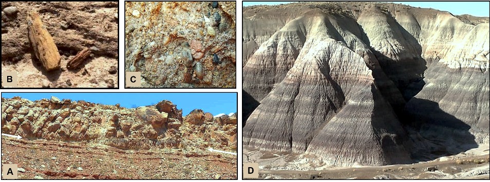
Along with various rock types and sedimentary features, the Chinle contains a variety of fossils (Figure 8). These include freshwater invertebrates, fish and other vertebrate remains, and abundant petrified logs and foliage. These plant remains often appear to be the result of local floods that transported the tree trunks and then deposited them as the floodwaters receded. Taken together, this evidence indicates that a variety of depositional environments occurred in the region (Figure 9).
Moenave Formation
This formation was recognized and named by J. W. Harshbarger, C. A. Repenning, and J. H. Irwin in 1957. It consists primarily of shale, siltstone, and sandstone and has been divided into two members: the lower Dinosaur Canyon Member and the upper Whitmore Point Member. It occurs in Arizona, Nevada, and southern Utah and has a maximum thickness of about 325 feet. Bedding surfaces preserve sedimentary features such as ripple marks and mud (desiccation) cracks and a diverse assemblage of dinosaur tracks, fish, and some plant fossils. The tracks, which were discovered by Dr. Sheldon Johnson in 2000, were the impetus for building the Dinosaur Discovery Museum in St. George (Figure 10).
Rock types, sedimentary structures, fossils, and trace fossils such as the dinosaur tracks all indicate that the Moenave Formation was formed in a terrestrial river and lake system in a humid subtropical environment. The rock record to the east of this area consists of sandstone that was accumulating in a more arid environment (Figure 11) and was slowly encroaching westward.
Kayenta Formation
This formation was named by A. A. Baker in 1936 and consists primarily of sandstone, siltstone, and shale. It is found in Colorado, Utah, Arizona, and Nevada. These rocks weather into distinct thin to medium beds and are brownish red to dark red to almost magenta with a maximum thickness of about 700 feet. In some areas, the lower interval is named the Springdale Sandstone (Figure 12).
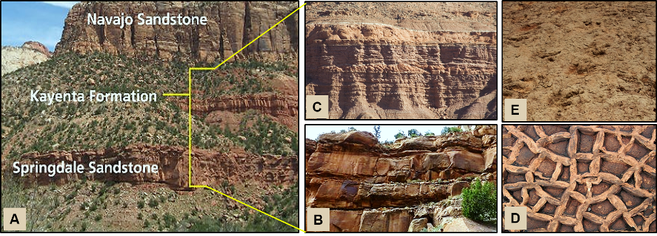
Lithologic features including mud cracks, ripple marks, and cross bedding plus a variety of vertebrate and invertebrate fossils indicate the depositional environments were streams, rivers, and floodplains similar to those for the underlying Moenave Formation. The lower Springdale Sandstone, which contains cross bedding, indicates that an arid desert environment was encroaching from the east, which eventually covered the region with extensive sand deposits.
Navajo Sandstone
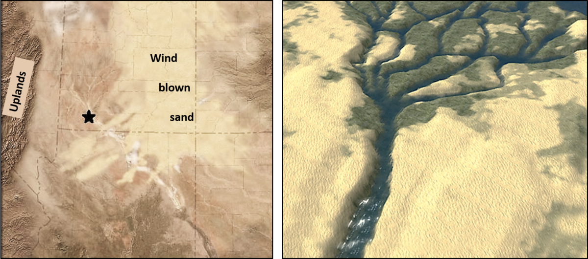
This formation was recognized and named by H. E. Gregory and R. W. Stone (1917), but it has been considerably revised since that time. These rocks are generally exposed as massive sandstone cliffs conformably overlying the brighter red Kayenta Formation, and they are spectacularly exposed in cliffs at Zion Canyon National Park and other parks in Utah. Well developed cross bedding (cross stratification) is common and represents ancient wind-deposited sand dunes. In some local areas, there are thin limestones that may contain fossils of freshwater-dwelling invertebrates. Dinosaur tracks occur in the rocks (Figure 13).
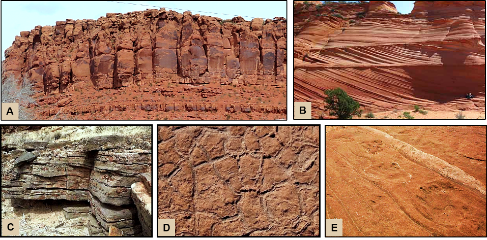
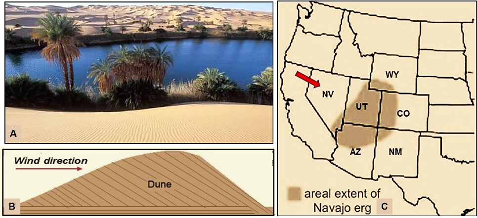
Based on rock types, various sedimentary structures, and fossil evidence, the Navajo Sandstone, along with other equivalent formations in the region, was deposited in a very large arid desert. A modern example of such an environment is provided by the Sahara Desert in northern Africa. Such a widespread sand sea is called an “erg” (Figure 14).
Summary
The figure below (Figure 15) summarizes the information discussed above. The photo, from the Capitol Reef area, shows the predominantly red rocks of the region. From the Kaibab Formation (not in the image) through the Navajo Sandstone, approximately 90 million years of geologic time are represented, although a significant amount of that time is represented by unconformities. Evident from the rocks and fossils are the distinct changes in depositional environments and climates that occurred during this interval. Other evidence from paleomagnetic studies indicates that the North American Continent was moving westward and northward during this interval as a result of the plate tectonic formation of the Atlantic Ocean.
Articles related to “Our Geological Wonderland: A record of ancient environments”
Our Geological Wonderland: The missing rock record in St. George
Our Geological Wonderland: An ancient seaway, right here in St. George


Rick, have you ever talked with anyone about the astroid that hit this area? Contact me and I’ll show you a few things I’ve been working on. Thank you.
some really nice and useful information on this website , besides I think the style holds great features.