

Hiking Southern Utah: Gifford Canyon in Zion National Park
*Please Note: Some trails may have been impacted by recent weather conditions, maintenance, or other natural occurrences. Be sure to check the ZNP website for any trail updates before planning your next adventure.
Trail: Gifford Canyon Trail
Location: Zion National Park
Difficulty: Easy, with three steep sections at the beginning
Distance: Less than three miles round trip
Average Hiking Time: Two to three hours at a leisurely pace
Elevation Gain: Less than 150 feet
Family-Friendly: Yes, but beware the first section has three rocky steep inclines
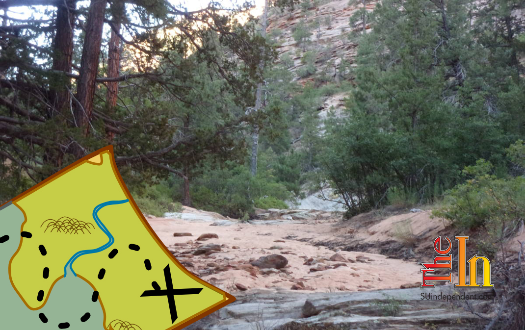
Getting there: From St. George, drive to Hurricane via Interstate 15 and State Route 9. In Hurricane, stay on State Route 9 and follow the signs to Zion National Park. It is about 45 minutes driving time from St. George to Zion.
Beyond the south entrance station at Canyon Junction, continue on State Route 9 (aka Zion-Mt. Carmel Highway) as it heads east past the switchbacks and through the Zion-Mt. Carmel Tunnel. The small Gifford Canyon (and Canyon Overlook Trail) parking lot is on the right (south) immediately after the tunnel exit. If the lot is full, there are several small overflow parking areas further east on the road. If you are coming from the east, travel 5.2 miles past the east entrance station and park on the north side of the road, which leaves a short walk to the trailhead.
This year, we decided to take our chances and hiked a relatively unknown, secluded trail — Gifford Canyon — during Zion National Park’s peak tourist season. We calculated that few, if any, people would hike a “hidden” trail, especially before 8 a.m. This hike is not along a formal track, and the park does not list it as a maintained trail. But it is an easy hike up a colorful canyon with steep red rock canyon walls, plenty of vegetation, and deep blue Utah sky above.
The trailhead elevation is approximately 5,070 feet, and the mostly sand wash trail, about a three-mile round trip, has an elevation gain of less than 150 feet.
Prior to setting out, we asked the park ranger at the small kiosk near the mouth of the tunnel the appropriate way to enter Pine Creek, the access to Gifford Canyon.
The ranger pointed to a short brown trail-marker sign about 10 feet or so from the restrooms (at the back of the parking area) on the edge of the slope to Pine Creek. The sign had an arrow pointing downslope and read “River Access.” We started down the short, rocky, and not well-maintained user trail.
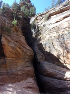
Once in Pine Creek, do not go right (a continuation of Pine Creek under the road leading to a technical slot canyon) or left (Clear Creek); these are separate hikes. Cross the wash a little toward the road and you will find a dry fall that is 25 feet high — the entrance to Gifford Canyon.
Since we did not have sticky pads for hands, we could not climb this near vertical rock wall. However, about 100 feet or so to the left (south) of the dry fall is a slickrock wall that is 20 feet tall. Follow the user trail on the left side of the slickrock up the slope. It’s not much of a trail, with a lot of bushes and rocks. About halfway up, the trail forks. Take the right fork and work around the ridge to come to a high overlook of Gifford Canyon. Scout around for the best path down and soon you’ll enter the sandy wash of Gifford Canyon.
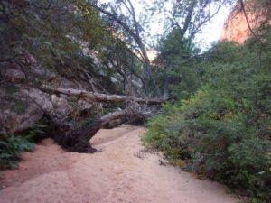
From here, simply follow the canyon upstream. About a quarter of a mile in, you’ll come to a small human-made dam. A bit later is an easy slickrock climb. The canyon wall on the left (east) is almost-vertical towering red sandstone, and the one to the right is a bit less steep. Most of the route is crowded with pine and cottonwood trees, ferns, and other vegetation.
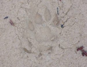
Since it had rained the day before, walking in the mostly sandy canyon bottom was not as onerous as it would have been if the sand was dry and loose. A side benefit to the moist sand was the well defined mountain lion tracks we followed for at least half a mile. The lion was heading downstream, and the tracks were very fresh with distinct edges. The tracks were large. It was a big boy or girl.
Because the canyon was fairly narrow with thick vegetation in most areas, this track was perfect for a mountain lion ambush. Once we saw the tracks, I picked up a stout “hiking stick.” I seldom hike with a stick, but this became an exception. We did not want the cat to have us for an early lunch without a fight. Fortunately, all we saw were the tracks as no mountain lion appeared.
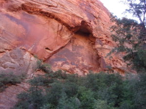
The end of the canyon is a semicircle of towering cliffs with a nice alcove about halfway up on the left and a huge slickrock slab on the right. With some difficult scrambling, one could mount the slickrock, but this enclosed area is a good place to stop.
This hike took about 2.5 hours at a leisurely pace. If you desire solitude, this is a hike for you. We did not see another person, and it was a type of quiet one seldom experiences in a crowded national park.


