
 The battle for the Northern Corridor, part II: The builders
written by Don Gilman
The St. George area has been growing at a large rate for decades. The once-small towns of St. George, Washington City, Ivins, and Hurricane have all seen tremendous growth. According to a report released by the U.S. Census Bureau earlier this year, the St. George metropolitan area was the fifth-fastest growing city in the United States. The combination of excellent weather, scenic beauty, and recreational opportunities (among other factors) has been luring many to make the move to Washington County. That growth will most likely continue for decades, but the influx of new residents will also bring new challenges, and one of those anticipated difficulties is traffic.
Area traffic can be congested, but not when compared to larger cities such as Las Vegas and Salt Lake City. However, as the population grows, that may change. Without a cohesive plan to mitigate the increase in vehicles, the results could be potentially debilitating.
The Dixie Metropolitan Planning Organization is one of the entities in charge of finding solutions to these anticipated problems. Under the umbrella of the Five Counties Association of Governments—which includes Beaver, Garfield, Iron, Kane, and Washington Counties—the DMPO has been studying the possibility of the Northern Corridor (also known as the Washington Parkway) for many years. Despite the creation of the Red Cliffs National Conservation Area, plans have been in place with the assumption that eventually the parkway would be approved.
There was once a time, not too long ago, when considerations about the welfare of animals and the effects of human development on their habitats was given little to no thought in our country. It was a human-centric world, and animals were just resources to be used as was seen fit. Times change. With awareness and an increasing knowledge of ecosystems and the dynamic relationship of all of nature, humans began to shift their thinking. The 1960s brought a revolution in environmental activism that changed minds, hearts, and—most importantly—laws. Since that era, regulations on growth and land use have become much stricter. Yet human expansion has continued unabated.
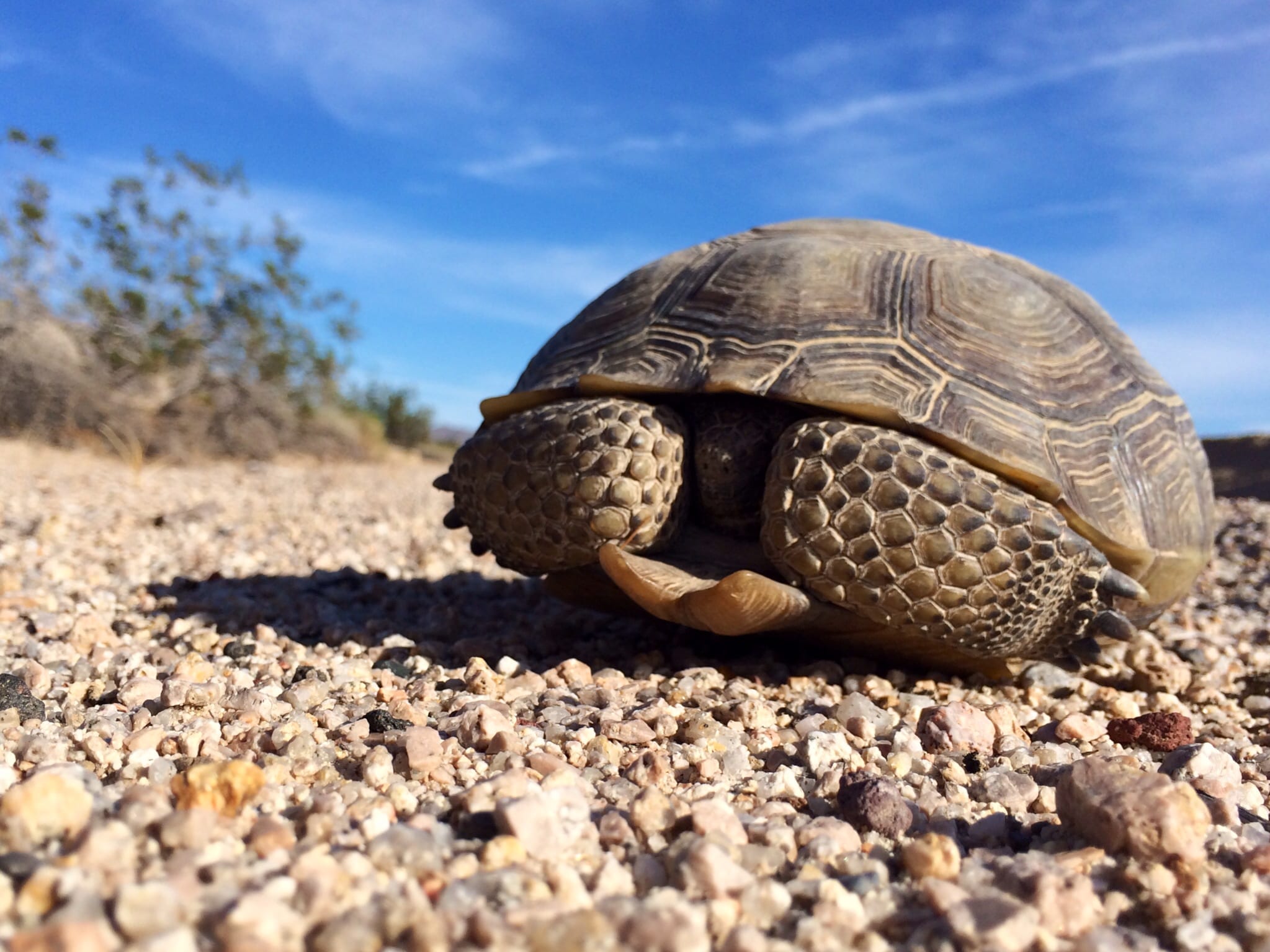
Washington County was once a quiet, sunny corner of Utah. Few could have accurately predicted the growth of the area several decades ago, and the Mojave desert tortoise was little more than a curious and unique critter that happened to roam the desert.
Now the municipal area of Washington County has expanded greatly, and the Mojave desert tortoise has become a rallying cry for some, a symbol for the dangers of over expansion. For others, it is a symbol of an intrusive government that values wildlife more than human needs, of a government that restricts growth more than encourages it. Here in Washington County, the fight over the Northern Corridor is truly a fight between the well-being of this reptile and the belief that the parkway is necessary to alleviate the traffic of a much larger future population.
According the DMPO’s Washington Parkway Cost-Benefit study, “[T]he primary purpose of the corridor has always been to reduce pressure on several key corridors such as Bluff St. and St. George Blvd. that are experiencing high levels of congestion and are expected to experience increased congestion in the future as the east/west travel demand increases.”
The study shows several proposed routes that the BLM has included in their recent DEIS (see part I of this series). The first is a long, winding route from The Ledges area near Snow Canyon State Park and runs on dirt roads already in existence, all the way to Leeds. The second proposed route would provide a more direct route from The Ledges across the NCA and connect with the Washington Parkway at exit 13 on Interstate 15. The third option would connect exit 13 past T-Bone Mesa to Red Hills Parkway. The fourth alternative would go east from Skyline Drive, connecting to Green Springs Drive. Option five would connect The Ledges to Turkey Farm Road (aka Cottonwood Road). A final alternative would be a combination of the second and fifth options.
It is the third option that is the focus of both DMPO and their opponents. For the politicians, planners, architects, and their allies, it is the link that makes the most sense. The first option connects the wrong areas and is too long and winding to be of much use. The other options, while more useful than the first, still do not answer the anticipated traffic problems.
Myron Lee, director of the DMPO, says that the third option is the only one that makes sense.
“We’re looking for a way to accommodate 32,000 vehicles between I-15 and exit 13 and state route 18 north of Sunset [Boulevard.] What we are looking for is something between Washington and Ivins. The further north we push that road the less people would use it, the cost-benefit ratio blows up, but if you bring it down to those endpoints, the value is higher,” Lee said.
The DMPO used a Travel Demand Model to predict the patterns of future traffic by entering a variety of factors. Traffic analysis zones (socioeconomic zones within defined geographic areas) and transportation networks are the two inputs that go into the Travel Demand Model. From there, the model uses a four-step process to anticipate future traffic patterns.
An analysis of those traffic studies show that roads like St. George Blvd are currently operating at or near capacity while others—such as Red Hills Parkway—are currently under capacity. The goal of the Northern Corridor is to divert traffic away from those heavily congested areas and reroute it to roads like Red Hills Parkway.
“We need a way for traffic to get into and away from town without impacting those roads,” Lee said. “We need a relief valve for traffic to move, and we have looked at a way to increase capacity. We have more traffic demand than roads to handle it.”
Washington County Commissioner Alan Gardner has been working on the Northern Corridor for nearly two decades and agreed that the parkway represented the best viable means to relieve that future congestion.
“It needs to be built because we need to handle the traffic. The topography makes it really hard to build roads, there are only so many places we can build them, it’s a spot that works really well, that’s why it was identified initially,” Gardner said. “We need to carry traffic from north part of valley across to the western side.”
Gardner used the Washington City Greensprings interchange as an example of why the county needs the parkway to be built.
“The Washington interchange is a big failure. It’s just about impossible to get through it … we have to have the ability to move from one side of the county to the other side and [the Northern Corridor] seems to be the best,” Gardner said.
Gardner also stated that he felt the environmental concerns were overblown.
“It’s much ado about nothing,” he said, adding that construction of the corridor would not impact the Mojave desert tortoise due to mitigation efforts such as culverts to allow the populations to pass unhindered beneath the parkway.
Both Gardner and Lee also stated that if the Northern Corridor is built, one option to help the Mojave desert tortoise would be to close down the Cottonwood Road that runs north from East Red Hills Parkway. Currently, the tortoise populations on the east and west sides of Cottonwood are separated by fencing that lines both sides of the road. This limits genetic diversity of the tortoise, since the populations on either side cannot mate with one another.
“Turkey Farm Road divides the habitat in half,” Lee said. “It bisects it through the center. Tortoises on the east side can’t visit tortoises on the west side. [Tortoise] advocates are very concerned about that. If we built the [Northern Corridor], it would be a permeable road, and then we could take out five miles of the [Cottonwood] road, cut off public access. Stitch the whole reserve back together and still meet transportation needs.”
Lee also emphasized that the county and municipalities were working to fulfill their agreements for conservation.
“There is a commitment from UDOT and the DMPO to advance the conservation efforts of the tortoise on the reserve and also meet the transportation needs. We recognize that any considerations for a roadway would have to address the needs of the tortoise,” he said.
“Some environmental work was done and there are some options as far as mitigation goes,” Gardner said. “I think that mitigation takes care of that issue.”
Gardner acknowledged that the Fish and Wildlife Service was a major impediment to getting the parkway constructed.
“Fish and wildlife is not high in the idea,” he said. “It’s going to take some work with them, no question. The mitigation will help take care of that. We just have to negotiate. We’re still a few years out before this road is absolutely needed.”
Gardner also said that he was very pleased when the Senate proposed an amendment to the 2009 Omnibus Bill that would have specifically limited the Fish and Wildlife from blocking construction of the Northern Corridor. According to Gardner, this amendment has been withdrawn.
However, Gardner also says that the Northern Corridor plan has been in the works for years and that the BLM has known all along that it would have to include a plan for it in its newest DEIS.
“The BLM was directed to do this by Congress,” Gardner said. “It is one of the things we agreed to in our lands bill. We thought we had an agreement already worked out when we passed a land bill in ’99. Now [the BLM and Fish and Wildlife] are coming back and saying they are going to do it this way or that way instead.”
Lee also expressed frustration with those who oppose the corridor.
“This Northern Corridor has been on the plans for decades. There has always been a commitment that we could accommodate traffic needs. We don’t need it right now; we don’t need it today, but we are going to need it into the future. It’s been on the books for a very long time.”
If approved, the Northern Corridor would likely not be built for at least ten years.
Check back next week for the third part in this series: an analysis of the arguments.
RELATED STORIES:
– The Ghost Highway: The battle for the Northern Corridor, part I


 for many years. Despite the creation of the Red Cliffs National Conservation Area, plans have been in place with the assumption that eventually the parkway would be approved.)
If the road “culverts” are such a dandy idea, then why not just put culverts under Cottonwood road, as it now is, to allow the critters to mate? An whole new road is not necessary to achieve that. And, if the culverts are so effective as the good commissioner and M. Lee assert, then they should work on the existing road and save taxpayer money. Mr. Lee fails to acknowledge his own draft report recently out for comments that clearly states that roads won’t solve our traffic problems and that shows blockages will still occur on Bluff and other roads. Spending excessive amounts of our tax money on a road that won’t serve where future population and jobs will be (again, according to Mr. Lee’s own report) makes no sense at all. If a road has been in the plans for years, then it should have been in the paperwork that created the Reserve and is not.