Living within Washington County and the city of St. George in southern Utah, we are blessed with the occurrence and potential occurrence of at least four different and sometimes deadly natural disasters, which are commonly referred to as geologic hazards.

Our Geological Wonderland: Geologic hazards in St. George and southern Utah

Living within Washington County and the city of St. George in southern Utah, we are blessed with the occurrence and potential occurrence of at least four different and sometimes deadly natural disasters, which are commonly referred to as geologic hazards.
Figure 1. The surface of Earth (atmosphere, white line; hydrosphere, blue line; lithosphere, brown line) can be considered an interface where energy from nuclear fusion and nuclear fission interact. Therefore, some geologic hazards such as earthquakes and volcanic eruptions result from fission and others such as floods and mass movements result from fusion.

Living within Washington County and the city of St. George in southern Utah, we are blessed with the occurrence and potential occurrence of at least four different and sometimes deadly natural disasters, which are commonly referred to as geologic hazards. These hazards include flooding, mass movements such as landslides and rock falls, volcanic activity, and earthquakes.


Most people think of natural disasters as events like major hurricanes, catastrophic earthquakes, or lethal volcanic eruptions. These events and others are part of how the Earth functions and are the result of the interplay of two major sources of energy: solar energy from the Sun — nuclear fusion — and heat energy generated within the Earth — nuclear fission (Figure 1).

Hazards that result from the input of solar energy — fusion

Floods

We think of Washington County and surrounding areas as a desert environment. Yet we have a few year-round flowing rivers, two of which flow through the St. George area. They are the Virgin and Santa Clara Rivers, and every so often during significant storms, they reach flood stage. These rivers are part of a regional drainage system, a drainage basin, which eventually flows into the Colorado River at Lake Mead northeast of Las Vegas (Figure 2).


Living within Washington County and the city of St. George in southern Utah, we are blessed with the occurrence and potential occurrence of at least four different and sometimes deadly natural disasters, which are commonly referred to as geologic hazards.
Figure 2. Drainage basin in Washington County (area in yellow). Various channels (tributaries) collect water and drain into the Virgin River, which in turn drains into the Colorado River. If rainfall in this basin exceeds the capacity of the Santa Clara or Virgin Rivers, a flood will occur. Source: Washington County Water Conservancy District.

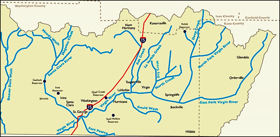
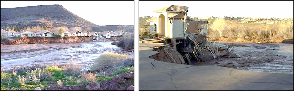
In Washington County and the city of St. George, these two rivers are the main channels draining water from rainstorms and melting snow. When the amount of water entering the system is greater than can be carried in these channels, such as during a major storm, the water overflows its banks and spreads out over land areas within areas appropriately termed “floodplains.” Thus, there are two situations in which a river can become hazardous. First is the possibility of erosion of the riverbanks themselves (Figure 3). Second is the possible flooding of the floodplain area (Figure 4).


Living within Washington County and the city of St. George in southern Utah, we are blessed with the occurrence and potential occurrence of at least four different and sometimes deadly natural disasters, which are commonly referred to as geologic hazards.
Figure 3. Santa Clara River flood of 2005. Homes and yards destroyed by erosion of the river banks during this winter flood.

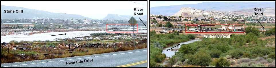
A readily observable flood plain can be seen extending from the south end of Foremaster (Middleton) Ridge to the base of Stone Cliff (Figure 4). As this example indicates, floodplains are generally nearly flat, lowland areas and are therefore relatively easy to develop and build structures. This tends to attract developers. When looking to rent, buy, or build a home or business, it is therefore important to consider whether the property is at the edge of a river channel or located within a floodplain.


Living within Washington County and the city of St. George in southern Utah, we are blessed with the occurrence and potential occurrence of at least four different and sometimes deadly natural disasters, which are commonly referred to as geologic hazards.
Figure 4. Left. Virgin River at flood stage covering part of its floodplain during winter in 2010. Note red outline. Right. Virgin River at normal flow within its main channel during summer in 2014). Note buildings and gas pumps constructed after the 2010 flood within red rectangle, and within the river’s flood plain. A barrier of boulders, a protective wall, is presumed to provide protection from a future flood.

Flooding of the Virgin River has played havoc periodically with human occupation in southwestern Utah ever since the first settlers arrived in 1861 and began to grow cotton. Can we expect further floods? The answer is yes, without a doubt. Can we determine when? The answer is no.

Mass movements

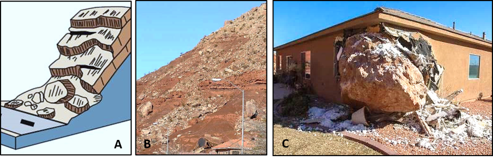
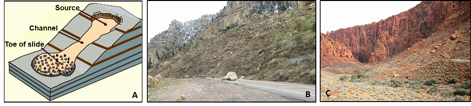
Although given a somewhat fancy name, mass movements in a geologic sense are essentially downslope movement of soil, rocks, and human structures. In the St. George area, we have concerns about rock falls, landslides, slumps, and soil flow (Figure 5). These hazards occur because we have topographic highs, potentially weak rocks and soils, and of course gravity. In contrast, areas such as Iowa are not likely to have much in the way of mass movements because they are topographically nearly flat.

Living within Washington County and the city of St. George in southern Utah, we are blessed with the occurrence and potential occurrence of at least four different and sometimes deadly natural disasters, which are commonly referred to as geologic hazards.
Figure 5a. Rock fall. A. Diagram of a rock fall. B. Rock falls along River Road. Uppermost light brown rocks are the Shinarump Conglomerate of the Chinle Formation. C. Major damage to a home from a rock fall at the east side base of Foremaster (Middleton) Ridge (2013).
Living within Washington County and the city of St. George in southern Utah, we are blessed with the occurrence and potential occurrence of at least four different and sometimes deadly natural disasters, which are commonly referred to as geologic hazards.
Figure 5b. Landslide. A. Diagram of a landslide. B. Landslide across Utah Highway 14 (Cedar Canyon). C. Landslide in the Kayenta area of St. George.
Living within Washington County and the city of St. George in southern Utah, we are blessed with the occurrence and potential occurrence of at least four different and sometimes deadly natural disasters, which are commonly referred to as geologic hazards.
Figure 5c .Slump. Left. Diagram of slumping. Right. Slump blocks of basalt lava on the west side of Foremaster (Middleton) Ridge.

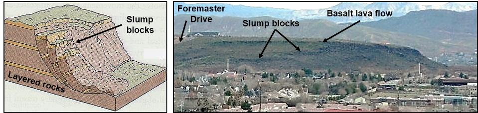
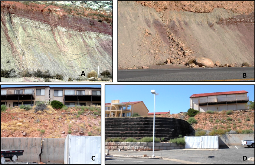
Making things out of clay in a ceramics class is fun and creative. In contrast, “don’t build on blue clay” is a common phrase heard in St. George. And for good reason as this particular clay is unstable and the cause of a number of slumps and slides that have damaged or destroyed roads and buildings around the city and adjoining areas (Figure 6). From a geologic perspective, our blue clay has an interesting history that extends back in geologic time to the Triassic Period a little over 200 million years ago. This clay primarily occurs within the upper member of the Chinle Formation. This member, known as the Petrified Forest Member, received its name from exposures at Petrified Forest National Park in northern Arizona.

Living within Washington County and the city of St. George in southern Utah, we are blessed with the occurrence and potential occurrence of at least four different and sometimes deadly natural disasters, which are commonly referred to as geologic hazards.
Figure 6. Unstable soils and slides. A and B. Close up of blue clay in a road cut along Riverside Drive at the south end of Foremaster (Middleton) Ridge. Note that the exposed clay-rich soil appears to be “flowing” down the cut. C and D. Condominium along Bluff Street that has split due to movement of the unstable hillside and was subsequently removed. Note new “retaining” wall.

Hazards that result from the input of internal energy — fission, radioactive decay

Volcanic eruptions

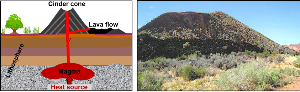
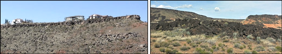
Along with other areas of southern Utah, northern Arizona, and southern Nevada, Washington County has been a region of significant volcanic activity for over 30 million years. The most recent activity has been eruptions of lava and formation of cinder cones. These volcanic features form abundant and distinctive features in this area (Figure7). Although there is still a source of heat below the surface as indicated by hot springs in the area, current assessment by the Geological Survey indicates a very low probability of an eruption in the near future.

Living within Washington County and the city of St. George in southern Utah, we are blessed with the occurrence and potential occurrence of at least four different and sometimes deadly natural disasters, which are commonly referred to as geologic hazards.
Figure 7a. Left. Diagram of a volcanic cinder cone. Right. Cinder cone and lava flow along Highway 18 at the turnoff to Diamond Valley.
Living within Washington County and the city of St. George in southern Utah, we are blessed with the occurrence and potential occurrence of at least four different and sometimes deadly natural disasters, which are commonly referred to as geologic hazards.
Figure 7b. Left. Basalt lava ridge. A great place to build a home with a view? East side of Foremaster (Middleton) Ridge. Right. Small volcanic basalt lava flow. Snow Canyon area.

Earthquakes

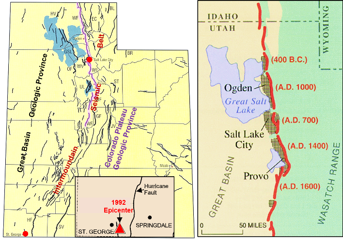
Utah is neatly bisected by numerous faults that form what is known as the Intermountain Seismic Belt (Figure 8). This belt trends northeastward from the southwestern part of the state up into Idaho. It is a region of numerous earthquakes, most of which are relatively small. But occasionally, a larger one occurs. The most recent significant earthquake in the St. George area occurred in 1992 and registered a magnitude of 5.5–5.8 on the old Richter scale. General consensus by the Utah Geologic Survey is that there is a low probability of a large quake in the southern part of the state. Farther north, around Salt Lake City, there could be a strong earthquake within this century.

Living within Washington County and the city of St. George in southern Utah, we are blessed with the occurrence and potential occurrence of at least four different and sometimes deadly natural disasters, which are commonly referred to as geologic hazards.
Figure 8. Left. Map of Utah showing Intermountain Seismic Belt. Note the purple line, which represents the trace of the Wasatch Fault. Right. Wasatch Fault Zone with a list of previous major earthquakes along various segments. Inset shows epicenter for M 5.5–5.8 earthquake in St. George in 1992. (Our Geological Wonderland: St. George has its Faults. The Independent, 10/16/18).

Other “self-induced” geologic hazards

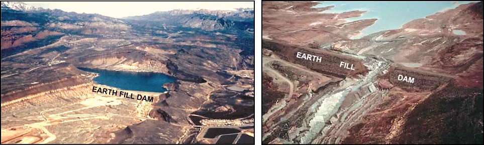
Some geologic hazards, which may have a low probability of occurring, are frequently exacerbated by human activities — for example, building on an unstable slope or at the base of a slope where there have been previous rock falls or landslides, building on blue clay, or building in a flood zone. In some of these conditions, there is little likelihood of a geologic hazard until one is actually created by construction. One example is provided by the history of the Quail Creek Reservoir and Dam, which was completed in 1985, failed on New Year’s Day in 1989, and created a large but temporary flood along the Virgin River (Figure 9).

Living within Washington County and the city of St. George in southern Utah, we are blessed with the occurrence and potential occurrence of at least four different and sometimes deadly natural disasters, which are commonly referred to as geologic hazards.
Figure 9. Quail Creek Dam and Reservoir. Construction completed 1984 and failed January 1989, a result of soluble gypsum in the underlying rocks. (Our Geological Wonderland: Quail Lake and the Virgin Anticline. The Independent, 08/05/18).

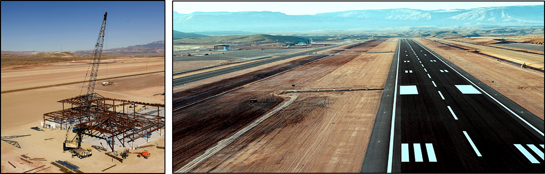
A second example is provided by the runway at the St. George Municipal Airport, which was completed in 2011. The runway is scheduled for a complete rebuild, which will require closing the airport from May through August 2019. The problem is the result of original construction on expandable blue clay, lack of deep enough excavation for the runway bed, and lack of installation of barriers to prevent water from seeping into the clay layers below the runway surface (Figure 10).

Living within Washington County and the city of St. George in southern Utah, we are blessed with the occurrence and potential occurrence of at least four different and sometimes deadly natural disasters, which are commonly referred to as geologic hazards.
Figure 10. Construction and finished runway at St. George Municipal Airport in 2011.

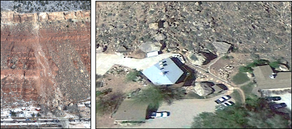
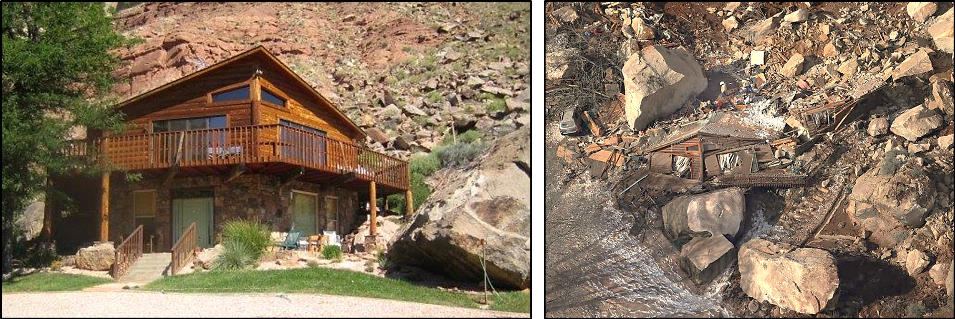
A third example occurred in Rockville in December 2013 and resulted in the total destruction of a home and the death of the two occupants from a very large rock. Apparent from the following images is the hazardous location of the destroyed home as well as other homes in close proximity (Figure 11). This is an example of poor decision making. Based on the geologic evidence of numerous large rock falls, these homes and others not in the picture are pretty much like bowling pins waiting to be knocked down.

Living within Washington County and the city of St. George in southern Utah, we are blessed with the occurrence and potential occurrence of at least four different and sometimes deadly natural disasters, which are commonly referred to as geologic hazards.
Figure 11a. Left. Image of the cliff in Rockville. The ridge-forming brown layer at the top is the Shinarump Conglomerate of the Chinle Formation. Evident is the scar made by a large boulder that broke loose from the Shinarump and crashed down the cliff into the homes below. Right. Note the homes that are surrounded by very large boulders — evidence of previous and continuing rock falls.
Living within Washington County and the city of St. George in southern Utah, we are blessed with the occurrence and potential occurrence of at least four different and sometimes deadly natural disasters, which are commonly referred to as geologic hazards.
Figure 11b. Left home in Rockville. Right. The home was completely destroyed in 2013 by a very large boulder of Shinarump Conglomerate.

Looking on the positive side, we don’t have hurricanes, tornadoes, major blizzards, or tsunamis. Geologic hazard maps of the St. George area can be accessed here.

Articles related to “Our Geological Wonderland: Geologic hazards in St. George and southern Utah”

Our Geological Wonderland: Volcanoes in southern Utah

Our Geological Wonderland: St. George has its faults

Our Geological Wonderland: Blue clay

Click This Ad

3 COMMENTS

  1. Unknown is a very scary thing, but not for us. We are one of many families who simply fell in love with the landscape in this area and determined to move to St. George, Utah. We’ve done a lot of research from Utah Government Websites and many articles like yours. Thank you for publishing your knowledge and expertise that re-enforce our decision of where we want to relocated ourselves and to enjoy our lives in such a beautiful City.

LEAVE A REPLY

Please enter your comment!
Please enter your name here