St. George is near two faults and earthquakes in southern Utah near the Intermountain Seismic Belt and Wasatch Fault system are due within 50 years or so.

Our Geological Wonderland: St. George has its faults

Faults and earthquakes in southern Utah

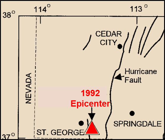
In the early morning hours of Sept. 2, 1992, St. George residents, all 29,000 or so of them, got a small taste of what happens in California. There was a significant earthquake with an epicenter very close to the city (Figure 1). This quake registered a magnitude of between 5.5 and 5.8 on the Richter scale and therefore was classified by seismologists as a “moderate” earthquake — kind of ho-hum by California standards but impressive by southern Utah standards. Some minor structural damage was reported along with some rock falls and landslides. There was no major damage, and there were no fatalities. So how come it happened here? (Optional answer: It’s not because so many retirees from California have moved here.)

St. George is near two faults and earthquakes in southern Utah near the Intermountain Seismic Belt and Wasatch Fault system are due within 50 years or so.
Figure 1. Simplified map of southwestern Utah. The epicenter of the 1992 earthquake was located about five miles southeast of St. George and just east of the Washington Fault.

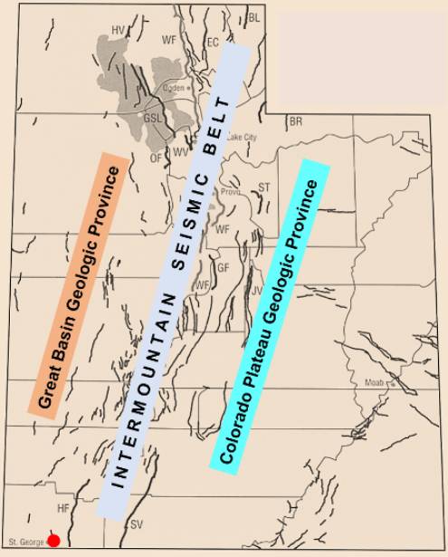
Well, as it turns out, like California, Utah has a lot of faults. Well, besides those faults, what I’m talking about are geological faults, the kind that are associated with earthquakes. There exist a relatively large number of such faults within the state, and as reported by the Utah Geological Survey and the United States Geological Survey, quite a few of those are potentially hazardous in the sense that they have in the past and could again cause significant earthquakes. A seismically active zone that extends diagonally through the state from the Arizona Strip up into Idaho is known as the Intermountain Seismic Belt (Figure 2). The location of this belt pretty much defines a boundary between geologic provinces of the Basin and Range to the west and the Colorado Plateau to the East.

St. George is near two faults and earthquakes in southern Utah near the Intermountain Seismic Belt and Wasatch Fault system are due within 50 years or so.
Figure 2. Fault map of Utah indicating the Intermountain Seismic Belt. This belt delineates where known faults occur (black lines). Red dot is St. George (Modified from UGS and USGS).

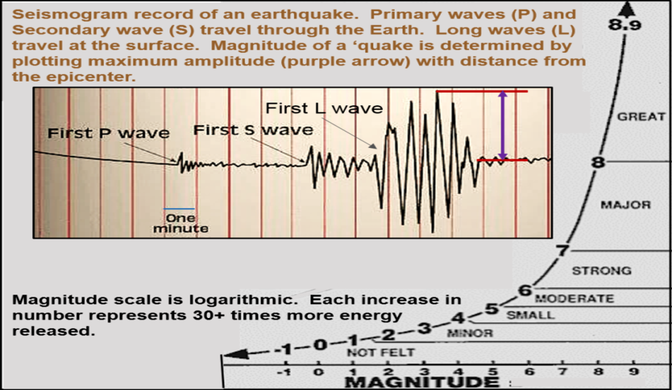
A geologic fault is the result of physical forces (stress) on rocks of the outer rock layers of Earth, which are known as the lithosphere. This stress can be in the form of compression, tension, or shear. When rocks break and shift position, an earthquake is generated, and a fault is formed. For over 100 years, earthquakes have been categorized on the basis of their size and energy (Figure 3).

St. George is near two faults and earthquakes in southern Utah near the Intermountain Seismic Belt and Wasatch Fault system are due within 50 years or so.
Figure 3. Richter earthquake magnitude scale developed by Charles Richter, a seismologist at Cal Tech in the 1930s. It has been modified and is now known as the moment magnitude scale, but either scale basically indicates the energy released by an earthquake. I wonder about earthquakes with a magnitude of eight or higher … not sure I would call them “great,” more like devastating!

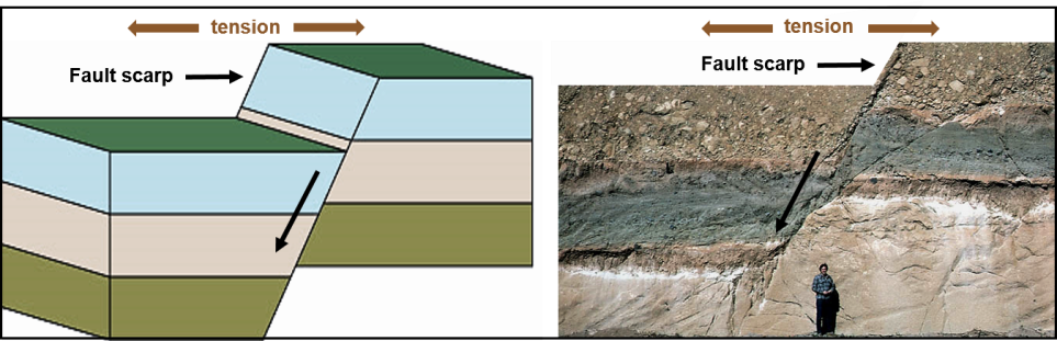
Geologists recognize a variety of different types of faults, which are named on the basis of how rocks shift relative to one another. The most common type of fault in Utah is known as a “normal fault” (Figure 4). Such a fault forms as a result of tension, or forces acting to pull apart rocks, kind of like a tug-of-war. When the rocks break, one side shifts downward relative to the other side.

St. George is near two faults and earthquakes in southern Utah near the Intermountain Seismic Belt and Wasatch Fault system are due within 50 years or so.
Figure 4. Diagram model and actual example of a normal fault. A recently formed fault scarp can be very evident at the surface but over a long interval of time may be eroded so that the ground surface becomes nearly leveled across the fault.

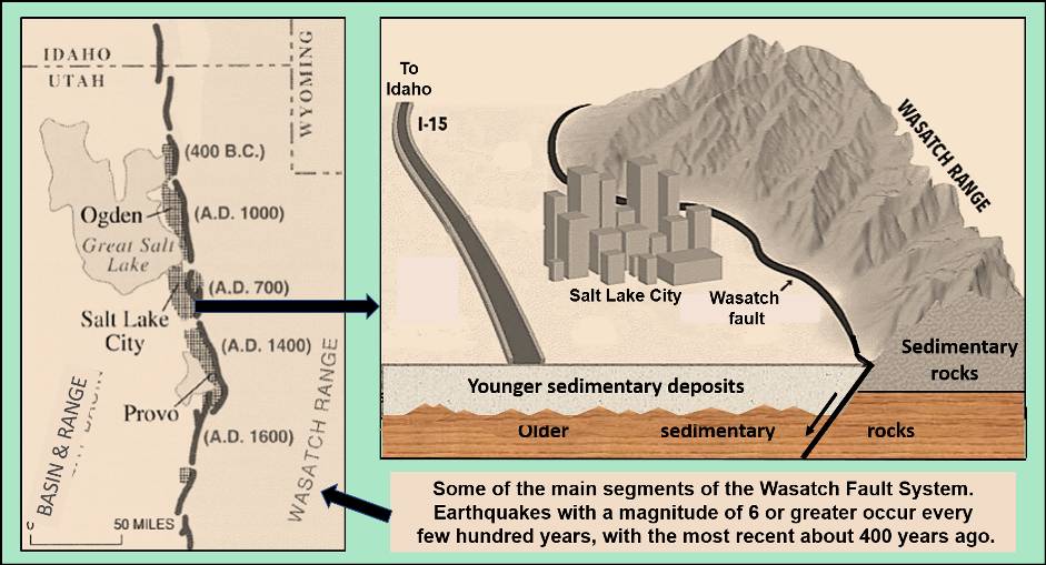
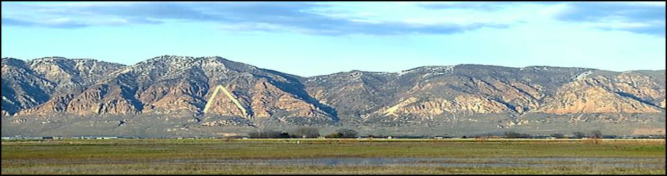
The central and northern portion of the seismic belt is more active and has more faults and earthquakes then the southern part. One major fault is well known as the Wasatch Fault, which is actually a number of fault segments that have been active for at least over 2.5 million years (Figures 5). Viewed from the Salt Lake Valley, the west side of the Wasatch Range shows a distinctive fault scarp and also how erosion has subsequently modified the scarp (Figure 6).

St. George is near two faults and earthquakes in southern Utah near the Intermountain Seismic Belt and Wasatch Fault system are due within 50 years or so.
Figure 5. Map and cross-section view of the Salt Lake segment of the Wasatch Fault. The overall length of the fault is about 240 miles, but most of the individual segments are around 24–25 miles long. Land west of the fault has dropped down along a series of normal faults, an episodic process that has been occurring for at least the last 2.5 million years. A short reference: en.wikipedia.org/wiki/Wasatch_Fault
St. George is near two faults and earthquakes in southern Utah near the Intermountain Seismic Belt and Wasatch Fault system are due within 50 years or so.
Figure 6. A portion of the Wasatch Front south of Salt Lake City illustrating the fault scarp along the western edge of the Wasatch Range. Rivers eroding canyons create triangular shaped facets along the scarp face (white lines). Gentle slope at the base of the mountains represents alluvial fans.

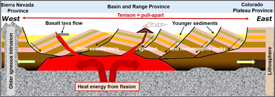
West of the Wasatch Range is the Basin and Range Province (Figure 7). This province represents a series of mostly north-trending mountain ranges separated by down-dropped valleys along normal faults. Because of tension pulling apart the rocks inn this area, the lithosphere has become thinner and faulted, allowing volcanic activity and hot spring (geothermal) areas to rise to the surface.

St. George is near two faults and earthquakes in southern Utah near the Intermountain Seismic Belt and Wasatch Fault system are due within 50 years or so.
Figure 7. Simplified east-west cross section from the Wasatch Range (Colorado Plateau Province), across the Basin and Range Province to the Sierra Nevada Province. The Basin and Range is being formed by tension, which is pulling the lithosphere apart and generating numerous faults. Volcanism is indicated and a lava flows indicated by gray rectangle associated with faults.
St. George is near two faults and earthquakes in southern Utah near the Intermountain Seismic Belt and Wasatch Fault system are due within 50 years or so.
Figure 8. Fault map of a portion of northern Arizona and southern Utah. These faults are a southern continuation of the Intermountain Seismic Belt. Note locations of the Hurricane Fault, Washington Fault, and epicenter of the 1992 earthquake.

Faults and earthquakes in southern Utah

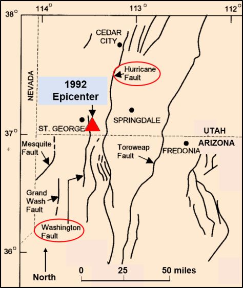
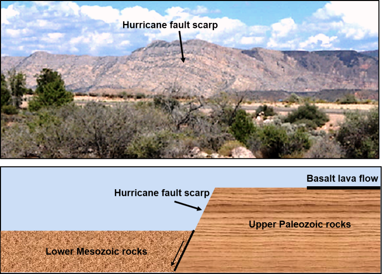
Of course, Washington County also has its faults (Figure 8). These faults represent the southern portion of the Intermountain Seismic Belt and represent a transition region between the Colorado Plateau Province to the east and the Basin and Range Province to the west. Two main mapped faults near St. George are the very long Hurricane Fault and the shorter Washington Fault, which runs through the city. The most distinctive is the Hurricane Fault, which is well exposed along the base of the Hurricane Cliffs (Figure 9). As indicated, it is a normal fault, and it can be traced from northern Arizona generally northward to just past Cedar City.

St. George is near two faults and earthquakes in southern Utah near the Intermountain Seismic Belt and Wasatch Fault system are due within 50 years or so.
Figure 9. Image and cross section of Hurricane Cliffs and Hurricane Fault. This fault is a west-dipping normal fault. The cliffs are mostly Upper Paleozoic (Permian) rocks with a cap of young basalt lava (upper right in photo and cross section). The valley floor, which has shifted down consists of Lower Mesozoic (Triassic) rocks that are mostly covered by younger sediments eroded from the cliffs.

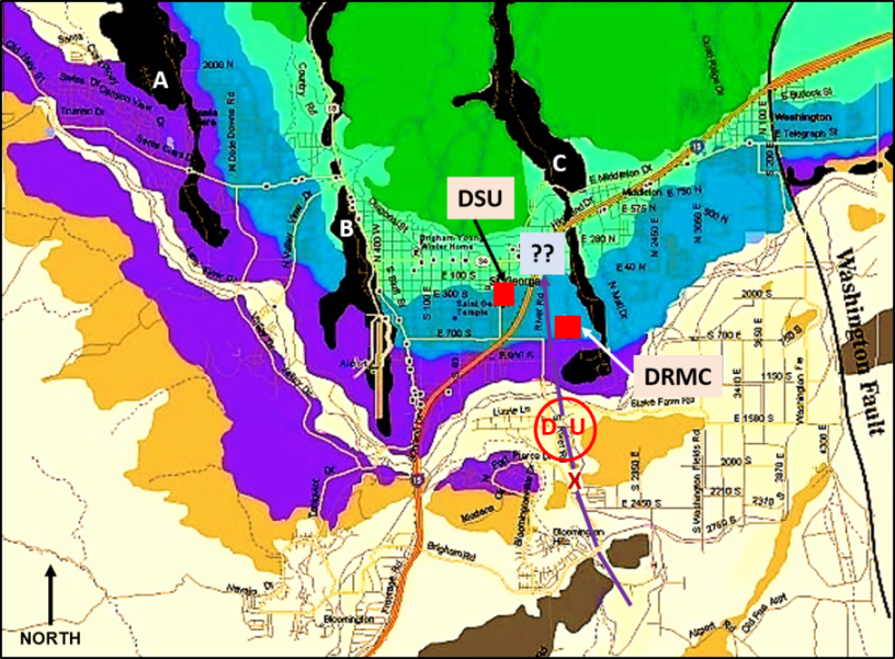
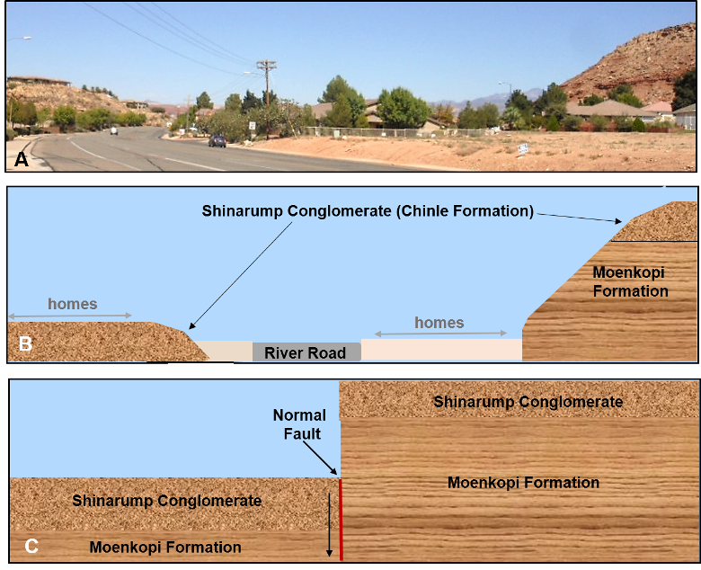
Two faults occur within St. George and Washington Cities (Figure 10). Distinct evidence of this fault can be seen on River Road, looking north from near the intersection with 2450 S, and it appears to also be a normal fault (Figure 11), but I do not have evidence from below the surface.

St. George is near two faults and earthquakes in southern Utah near the Intermountain Seismic Belt and Wasatch Fault system are due within 50 years or so.
Figure 10. Geologic map of a portion of St. George and Washington City. Although not present on the original map, I have added a fault. It is indicated by the dashed purple lines. Its trace roughly parallels River Road with the west side having shifted down relative to the east side (normal fault). Also note that Dixie Regional Medical Center and Dixie State University are in close proximity to this fault trace. Letters A, B, and C represent the prominent basalt lava ridges in St. George.
St. George is near two faults and earthquakes in southern Utah near the Intermountain Seismic Belt and Wasatch Fault system are due within 50 years or so.
Figure 11. Evidence for the fault along River Road. A. Looking north on River Road from 2450 South (see “X” on Figure 10). Brown rocks at the top of the right-side cliff are the Shinarump Conglomerate of the Chinle Formation. The same rock layer is on the left side, with homes built on it, but is much lower in elevation. B. Diagram to illustrate what is evident in the photograph. C. Model to show the normal fault, before erosion. I have drawn it in a vertical position, but it is likely tilting towards the west below the surface.

Be prepared

The Utah Geological Survey has published an earthquake preparedness report that provides very useful information, especially for the central and northeastern parts of Utah. These areas, which are within the Intermountain Seismic Belt and especially in close proximity to the Wasatch Fault system, are more likely to experience a large-scale earthquake than the southern part of Utah. Recently published estimates from the USGS (2016) suggest about a 43 percent chance of a magnitude 6.5 or greater earthquake along the Wasatch Fault within the next 50 years. This estimate is based on detailed studies of the recurrence history along various segments of the fault. The Utah Geological Survey has also prepared some publications on this topic, including tips on earthquake preparedness, which can be accessed online here and here.

St. George is near two faults and earthquakes in southern Utah near the Intermountain Seismic Belt and Wasatch Fault system are due within 50 years or so.
Figure 12. Rock walls are a common feature in St. George. They are well constructed, and it’s interesting to watch one being built. However, in most the individual boulders are not attached to one another and are stacked basically like a bunch of toy blocks. All it takes is a bump … or a moderate earthquake … and entropy takes over the wall!

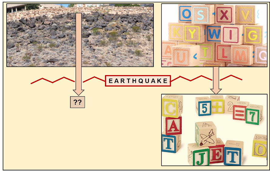
The structural faults in the St. George area have been active in the past and are also likely to generate an earthquake in the future. However, it is much less likely that any of them will generate a strong or a major earthquake with a magnitude greater than 6 as is likely in the northern part of the state. Nonetheless, considering the significant increase in population and various hilltop “scenic” building sites that have been developed since 1992, even a moderate quake will create damage, particularly rock falls and landslides (Figure 12). Roads, homes, and other structures built on blue clay and other unstable soils are likely to suffer some damage.


Articles related to “Our Geological Wonderland: St. George has its faults”

Our Geological Wonderland: Blue clay

Our Geological Wonderland: Quail Lake and the Virgin Anticline

Our Geological Wonderland: Dinosaur Discovery Site at Johnson Farm

Click This Ad

LEAVE A REPLY

Please enter your comment!
Please enter your name here