


Our Geological Wonderland: Quail Lake and the Virgin Anticline
Our story begins with a geologic disaster. Just after midnight on January 1, 1989, a dike holding back water in Quail Lake, a reservoir for St. George, failed, producing one of the largest historical floods in the Virgin River. Damage to various structures and roads totaled about $12 million, but fortunately, no lives were lost. The dike was rebuilt in the early 1990s, and there have been no failures since. The failure of the dike represents a recent event in the long history of the area and was the result of geologic conditions that were mostly ignored in building the dike.
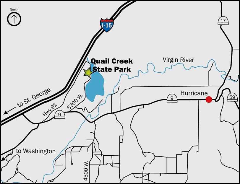
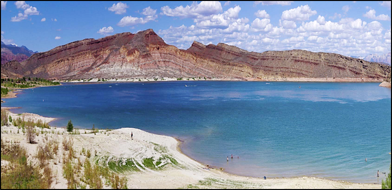
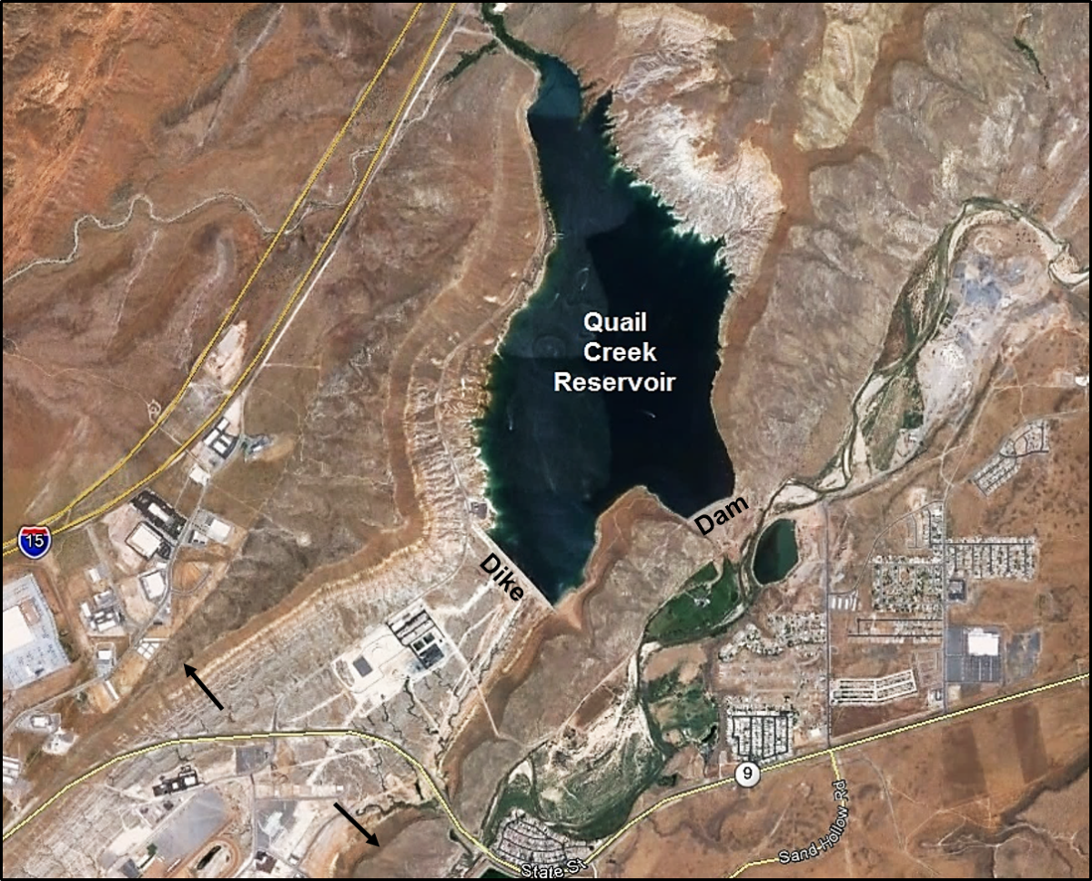
Quail Lake Reservoir is part of Quail Creek State Park (Figures 1 and 2). The park is very nice location for boating, swimming, fishing, picnicking, and just having a nice, relaxing day. Hiding in plain site at the lake are some interesting geological structures that played a major role in the dike failure. Unfortunately, the failure was also due to human errors. So what we have is an interconnected geological story and human-interest story.
Geological history of Quail Lake and the Virgin Anticline
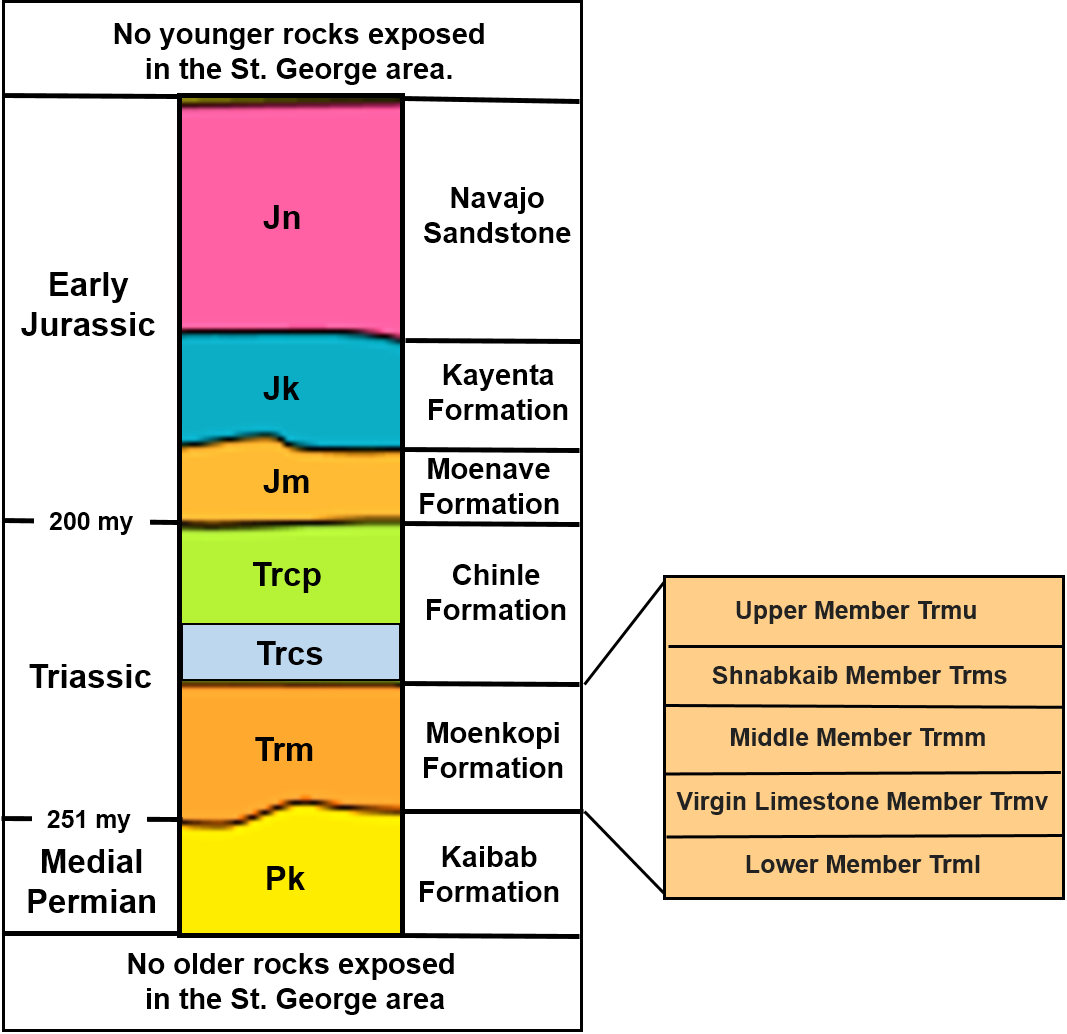
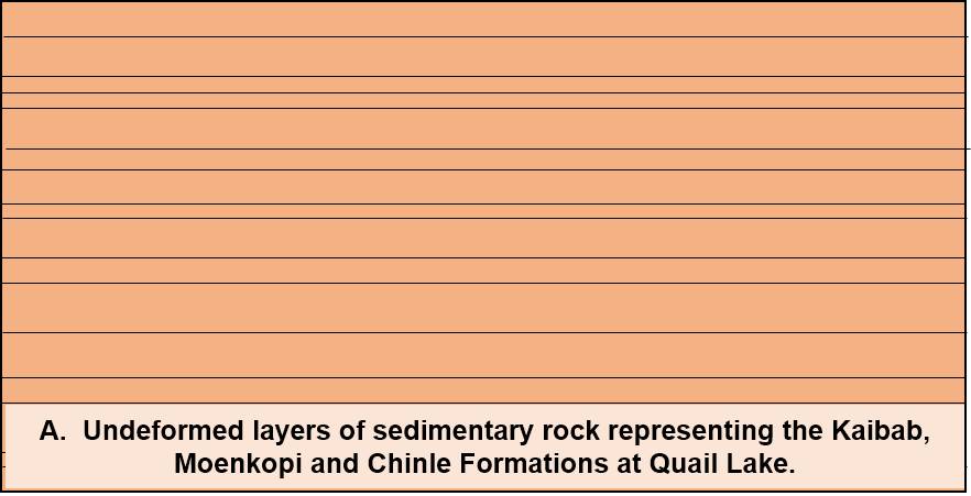
The oldest rocks exposed in the St. George area are known as the Kaibab Formation (Figure 3). This formation consists of limestone (calcium carbonate rock) and is the same formation that forms the plateau surfaces at the Grand Canyon, where it is the youngest rock unit exposed. Based on evidence from fossils within the formation and its position relative to underlying and overlying rocks, the Kaibab Formation formed during the Permian Period approximately 270 million years ago in a widespread warm shallow sea.
Overlying the Kaibab Formation and therefore of a younger geologic age is the Moenkopi Formation, which consists of a variety of different rocks types including thinly bedded sandstone, mudstone, limestone, and a distinctive mineral called gypsum (calcium sulfate). This gypsum was formed as an evaporite mineral from sea water on the floor of a shallow ocean during the Triassic Era. As we will see, this gypsum has played a major role in the human-interest part of our Quail Lake story.
On the basis of fossils and its position relative to underlying and overlying rocks, the Moenkopi Formation formed during Early and Medial Triassic time, about 240 million years ago (Figure 4). These rocks, which tend to appear reddish-brown or tan, were deposited in a variety of ancient environments such as a shallow water delta, extensive tidal flats, a river system, and floodplains, all of which are comparable to the modern-day Gulf Coastal area of the United States.
Overlying the Moenkopi, and therefore of a younger geologic age, is the Chinle Formation, which consists of a lower conglomerate member (Shinarump Conglomerate) and an upper shale and mudstone member (Petrified Forest Member). On the basis of vertebrate and plant fossils, the Chinle Formation formed in a complex river and lake system during Late Triassic time, a little over 200 million years ago.
As noted on Figure 3, younger rocks representing the Moenave, Kayenta, and Navajo Formations occur in Washington County and in St. George but are not present around Quail Lake due to erosion.
Beginning in the 1950s and 1960s, geologists made major discoveries that led to the recognition and verification of the Theory of Plate Tectonics. Applying this information to the rocks and structure at Quail Lake, it was recognized that during the time of deposition of the rock units listed on Figure 3, the western portion of what is now the United States was mostly low-lying land and shallow seas and was at the western edge of what is termed the supercontinent of Pangaea. Beginning in Early Jurassic time, about 180–200 million years ago, Pangaea began to split apart with the North American Continent “drifting” westward and overriding rocks of the Pacific Ocean Floor. This process is termed subduction (Figure 5) and at that time occurred where California exists today.
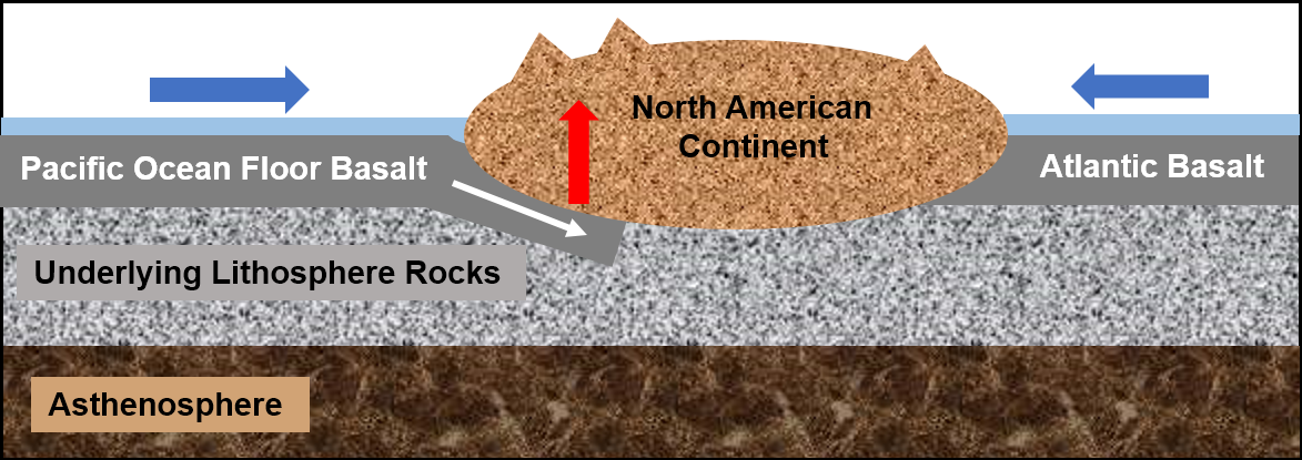
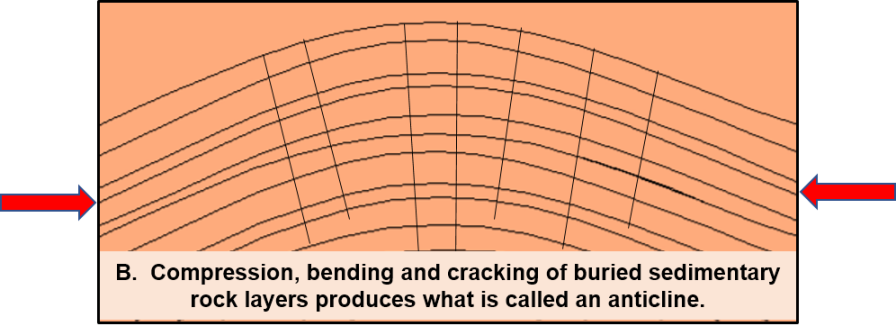
By Cretaceous time, the collision of westward-moving North America with the rocks of the Pacific Ocean floor had created a well-developed subduction zone where the rocks of the Pacific Ocean floor were overridden by the North American Continent. Among other events such as extensive volcanism where the present day Sierra Nevada occurs, this process produced widespread compressional uplift along with folding and faulting of rocks on the western part of the continent. During Late Cretaceous time, 70–80 million years ago, this process compressed and folded the buried Permian and younger rocks around what is now Quail Lake (Figure 6).
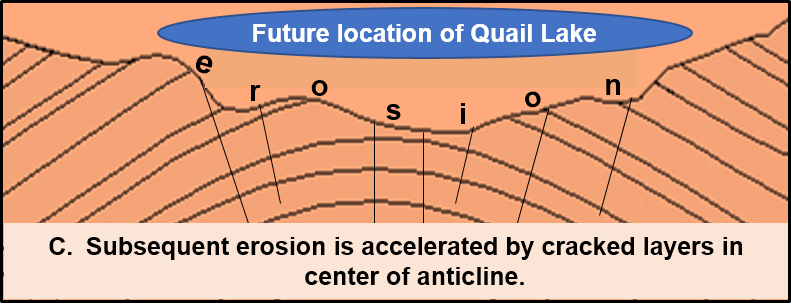
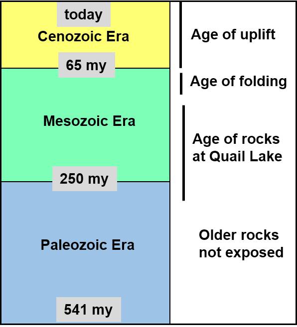
During the last 65 million years, representing the Cenozoic time (Figure 7), what is now called the Colorado Plateau has been uplifted by the same subduction process. This uplift has been coupled with erosion, which has formed many rivers, streams and very scenic geography as indicated by the many national parks and monuments of the plateau.
Virgin Anticline, the Quail Lake Reservoir, and a geologic hazard
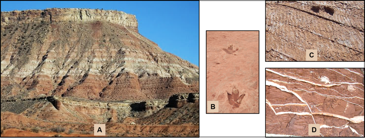
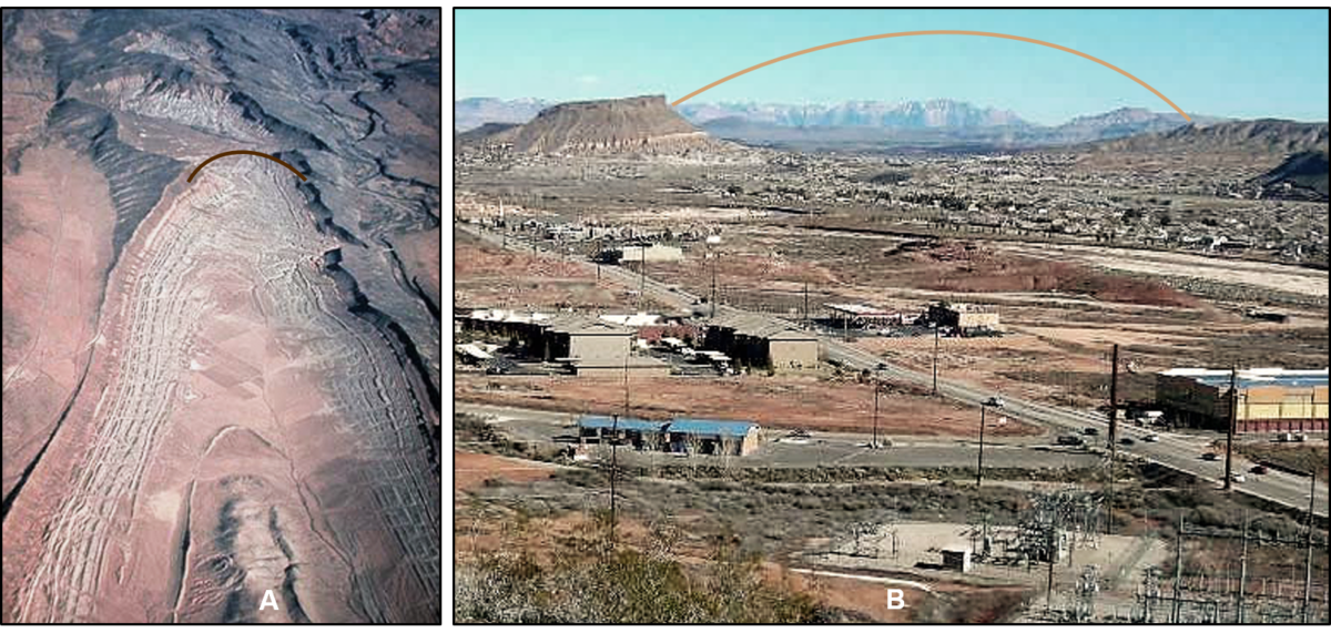
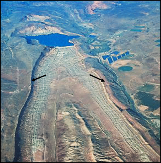
The Virgin Anticline is a distinctive geologic and topographic feature that extends from near Hurricane to about 30 miles southwest into St. George (Figure 8). As indicated by the images, the central (axial) part of the anticline has undergone significant erosion. Because it is so well exposed at the surface, this anticline is well known to geologists and is a common stop for many field trips.
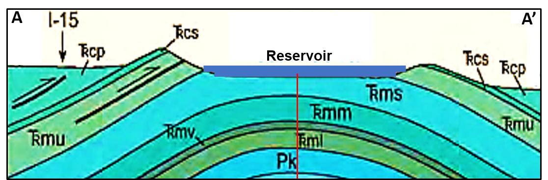
This distinctive geologic structure is also evident on a geologic map of the area, and it can also be illustrated on a geologic cross section (Figures 9 and 10). On the map and cross section, each rock formation and member is given its own color and symbol (note Figure 3).
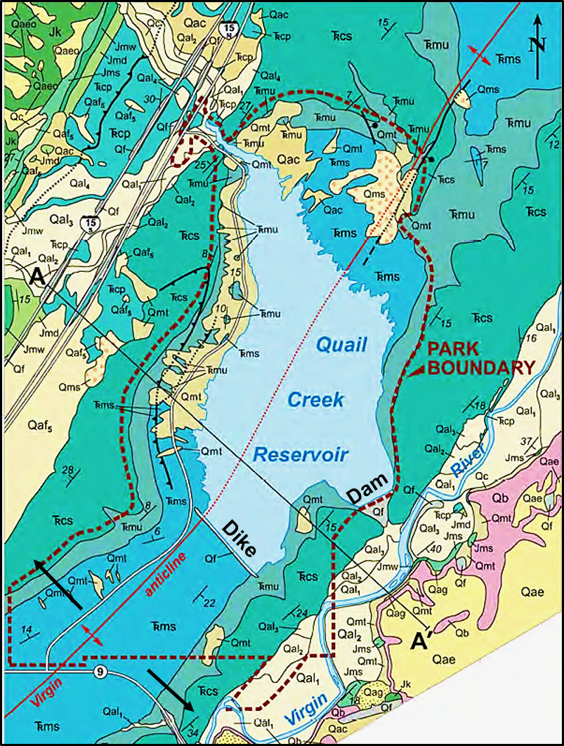
Considering future population growth of the St. George area, the Washington County Water Conservancy District proposed construction of a reservoir along Quail Creek, which is a tributary of the Virgin River. The eroded axis of the Virgin Anticline represented a good location for the reservoir, so plans were drawn up for construction. To impound the water, a dam and a dike were constructed in the mid 1980s with completion and filling of the reservoir by 1985. Both the dam and dike were constructed as earth-filled embankment dams. Some of the water for the reservoir comes from Quail Creek, but the majority comes from the Virgin River via a buried pipeline. Along with recreational activities, reservoir water is used for irrigation and culinary purposes (Figures 11 and 12).
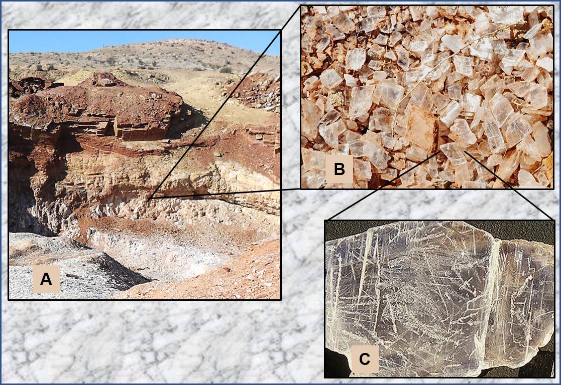
The constructed earthen dam and dike impounded water, covering the Shnabkaib Member of the Moenkopi Formation (refer back to Figure 3). This member consists of layers of sandstone and siltstone that were deposited on ocean tidal flats in a relatively hot climate. Along with the sediments, this ancient environment and climatic conditions resulted in the formation and precipitation of evaporite minerals, in particular a mineral called gypsum (CaSO4·2H2O), which is germane to our story. Gypsum is classified as a sulfate mineral, and it has a number of commercial uses such as in fertilizers and as the major component of plaster and drywall (wallboard). This mineral has been mined in St. George (glitter pit). (Figure 13).
There are two things to consider at this point.
First is that weathering and erosion have enhanced the joints and cracks in rocks of the Shnabkaib Member of the Moenkopi Formation (refer to Figure 6).
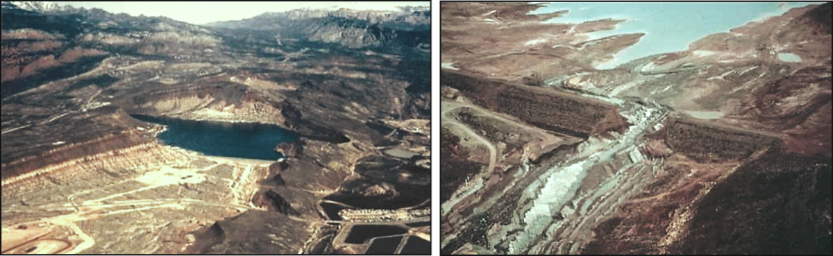
Second is the presence of gypsum in the Moenkopi. In hindsight from geologic and engineering standpoints, having a reservoir on a weathered and eroded sedimentary rock, especially a rock containing gypsum, is risky. Compounding this is the fact that well anchored, reinforced concrete was not used on the impound dike; rather, it was constructed as an earth-filled embankment. Problems appeared soon after completion and filling of the reservoir. By December 1988, seepage was occurring along the dike, and just after midnight Jan. 1, 1989, the dike failed (Figure 14). No lives were lost, but damages exceeded $12 million (in 1989 dollars). The dike was rebuilt as a rolled-concrete structure and is now termed “south dam.” It has held up nicely for nearly 30 years (see Figure 11).
So we have featured another location in our geological wonderland. It combines some interesting geologic events with some not-so-clever human activities that resulted in a serious geologic hazard and additionally provides resources and recreational facilities for St. George. The Virgin Anticline also plays a significant role in another area of geologic and commercial interest, which is known as the Silver Reef Mining District. A future article will provide a geologic and historic account of this location.
Articles related to “Our Geological Wonderland: Quail Lake and the Virgin Anticline”
Our Geological Wonderland: Dinosaur Discovery Site at Johnson Farm
Our Geological Wonderland: A trip through the Virgin River Gorge


