Our Geological Wonderland: The Virgin River has eroded two spectacular canyons: the Narrows in Zion National Park and the Virgin River Gorge in Arizona.

Our Geological Wonderland: The Virgin River flows through here

The Virgin River was originally named “Adams River” after President John Quincy Adams but was renamed “Virgin River” by John C. Fremont after Thomas Virgin, one of the first explorers in the region. In 2009, the Virgin River was designated as the first “wild and scenic river” in Utah.

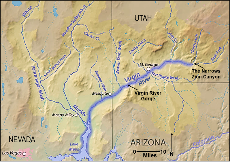
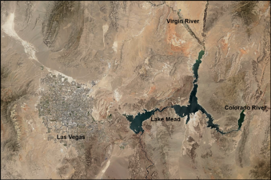
The Virgin River is a tributary to the Colorado River, and after a trip of approximately 162 miles from its headwaters near Zion Canyon, it enters the Colorado River at the north end of Lake Mead in Nevada (Figure 1).

Our Geological Wonderland: The Virgin River has eroded two spectacular canyons: the Narrows in Zion National Park and the Virgin River Gorge in Arizona.
Figure 1. Watershed drainage of the Virgin River and its tributaries. The Virgin River is itself a tributary to the Colorado River.

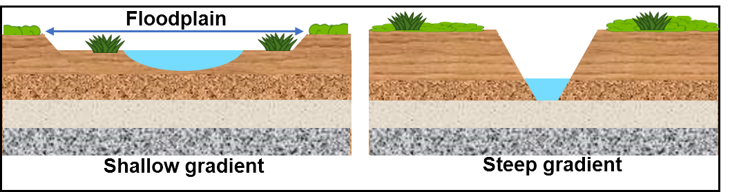
Streams and rivers flow over the surface of the Earth and form part of what is called the Hydrologic Cycle. In effect, this surface runoff moves water and carries various types of sediment that have been eroded from land areas. The moving water also erodes and shapes its own channel. The particular shape of a channel is a function of the type of rock present and the overall topography and the gradient (slope) of the ground surface. Over its course, the Virgin River has produced two main types of channels (Figure 2).

Our Geological Wonderland: The Virgin River has eroded two spectacular canyons: the Narrows in Zion National Park and the Virgin River Gorge in Arizona.
Figure 2. River cross-sections to illustrate the type of channel formed in a shallow gradient and in a steep gradient. In a shallow, relatively flat area, a river will meander and erode its banks from side to side and create a floodplain. In a steeply sloping area, a river will tend to erode downward to form a narrow channel with steep side walls and no floodplain.

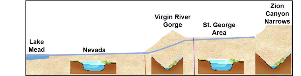
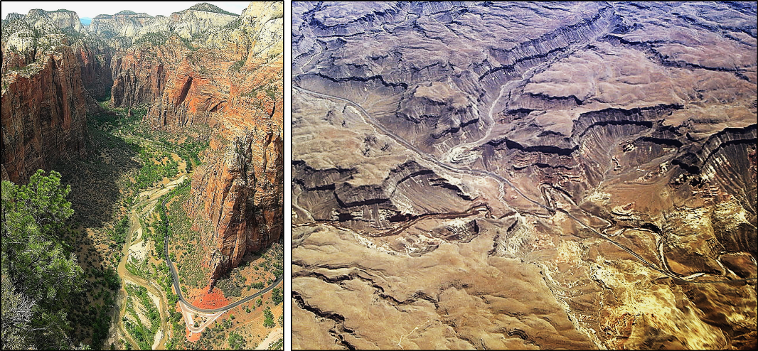
Along its route, the Virgin River has managed to erode two spectacular canyons. Much of this erosion occurred during the Ice Ages within the past 2.6 million years when climates were wetter and considerably more water flowed in the region. One of these canyons is the Narrows in Zion National Park, and the other is the Virgin River Gorge in Arizona. Both of these steep-sided canyons are quite spectacular. In other areas such as near St. George and in Nevada, the river flows in a wider, meandering flood plain.

These changes in flow are the result of the topographic gradient. In the Zion Canyon Narrows and the Virgin River Gorge, the topography and gradient are steeper; therefore, the river flows rapidly and erodes downward to produce a narrow, steep-sided channel. In areas with shallower topography, the river flows more slowly and erodes laterally to widen its banks and form a floodplain (Figure 3).

Our Geological Wonderland: The Virgin River has eroded two spectacular canyons: the Narrows in Zion National Park and the Virgin River Gorge in Arizona.
Figure 3. Longitudinal cross-section of the Virgin River. Insets indicate changes in shape of the river channel in response to the gradient. Virgin River Gorge is cut through the Beaver Dam Mountains where they meet the Virgin Mountains. Purple line is the Utah/Arizona boundary. Brown line is the Arizona/Nevada boundary.

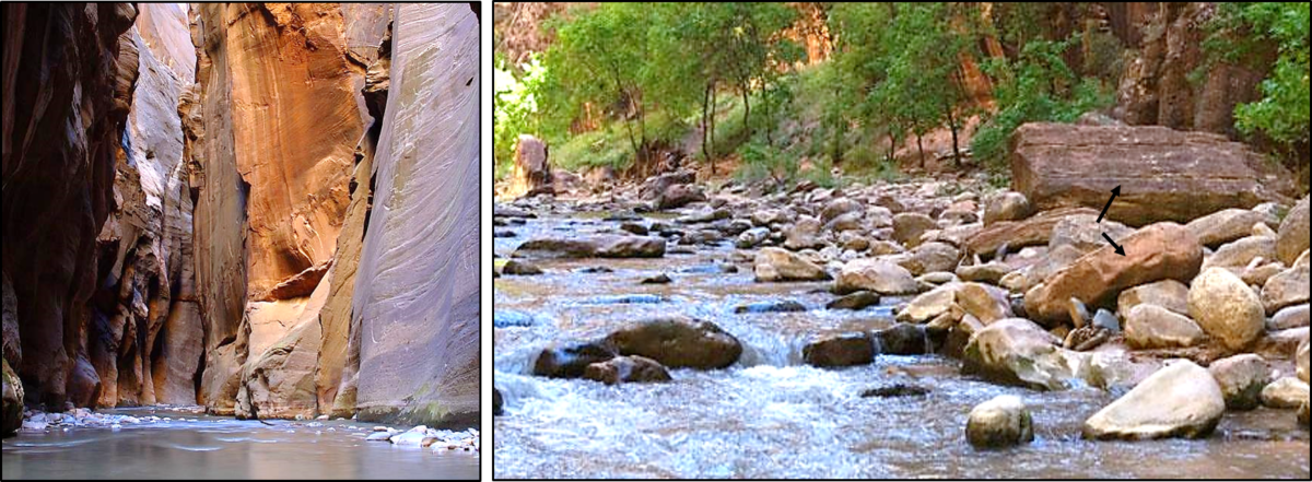
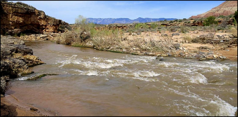
In the Zion Canyon area of the uplifted Colorado Plateau, the Virgin River has eroded a very narrow, steep-sided channel in the Navajo Sandstone (Figure 4). A popular place to hike is the Narrows, but it is an exceedingly dangerous place to be trapped during storms with flash flood possibilities and nowhere to escape. A testament to the power and volume of water in such flash floods is indicated by the size of the large boulders in the river channel. Note that there are two types of boulders, which are the result of two different types of erosion. Those transported by the river as part of what is termed “bed load” are generally smooth and somewhat rounded in outline whereas the boulders that have fallen from the canyon walls and have not yet undergone any transport by the water are angular and blocky (see arrows).

Our Geological Wonderland: The Virgin River has eroded two spectacular canyons: the Narrows in Zion National Park and the Virgin River Gorge in Arizona.
Figure 4. The Narrows, Zion Canyon. Left. Steep walls of the Navajo Sandstone, which have been eroded by the Virgin River into a steep, narrow channel. Right. A bit farther down the channel. Note two types of boulders in the river bed, which have resulted from two different types of erosion.

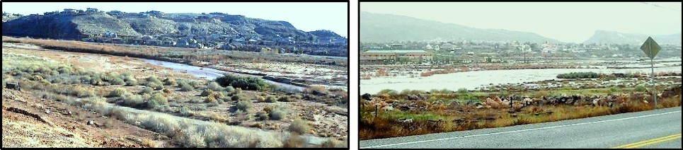
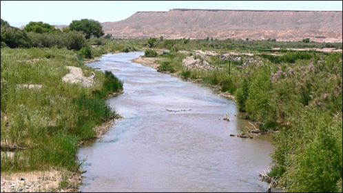
As the river flows out of Zion and reaches the relatively flatter portions around Hurricane and St. George, the velocity of the water decreases. In these areas, it has formed a wider channel and eroded mostly sideways to create a flood plain rather than cutting a steep-sided channel (Figures 5 and 6). During major storms such as ones that occurred in 2005 and 2010, this flood plain becomes partially or completely flooded.

Our Geological Wonderland: The Virgin River has eroded two spectacular canyons: the Narrows in Zion National Park and the Virgin River Gorge in Arizona.
Figure 5. Virgin River Falls near Hurricane. River water is still flowing strongly, although the gradient is much less then back in Zion Canyon. The brownish color of the water indicates that it is carrying a sediment load from erosion up-river. During drier seasons, the water is not carrying a significant sediment load and is clearer.
Our Geological Wonderland: The Virgin River has eroded two spectacular canyons: the Narrows in Zion National Park and the Virgin River Gorge in Arizona.
Figure 6. Virgin River in St. George. Here, the river has a shallow gradient and has formed a relatively wide floodplain. During the major storm of 2010, the river channel overflowed into a large portion of its floodplain. Images taken from Riverside Drive looking across the floodplain to the development of Stone Cliff and a bit south facing from approximately the same spot.

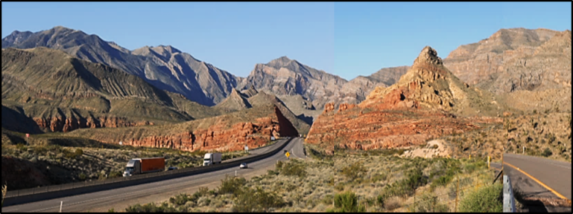
Significant downward erosion occurs again when the river reaches the Beaver Dam Mountains south of St. George and into Arizona. Because of the higher elevation of the mountains, the gradient has increased, and the river has eroded another steep-walled channel, known as the Virgin River Gorge (Figures 7 and 8). The river descends the west side of the mountains and flows out into the Arizona and then Nevada portions of the Virgin River Valley.

Our Geological Wonderland: The Virgin River has eroded two spectacular canyons: the Narrows in Zion National Park and the Virgin River Gorge in Arizona.
Figure 7. Middle portion of the Virgin River Gorge. Younger red rocks in foreground and older brown and gray rocks in the background. The lower and steeper part of the Gorge begins as the highway passes into the darker rocks. Image taken from overpass at exit 18.
Our Geological Wonderland: The Virgin River has eroded two spectacular canyons: the Narrows in Zion National Park and the Virgin River Gorge in Arizona.
Figure 8. Virgin River in lower part of the Virgin River Gorge. Again eroding its way through rocks to form a narrow, steep sided canyon. Note brown water, which is carrying a lot of eroded sediment.

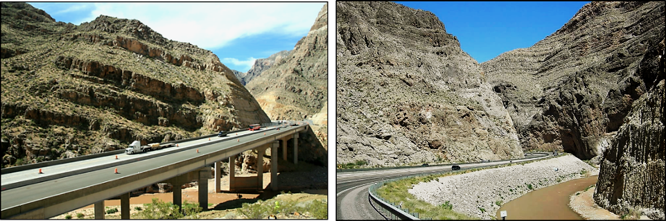
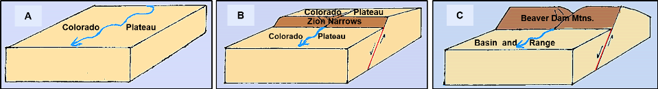
At this point on its journey, the river has eroded its way through two different highland areas, which include the Colorado Plateau and the Beaver Dam/Virgin Mountains (Figure 9). The term used to explain how that occurs is “antecedent stream.” In this model, the stream or river maintains its original course despite changes in underlying topography (Figure 10).

Our Geological Wonderland: The Virgin River has eroded two spectacular canyons: the Narrows in Zion National Park and the Virgin River Gorge in Arizona.
Figure 9. Aerial comparison of the Virgin River in two canyons. Left is Zion Canyon (Angels Landing photo) where the river has eroded through sandstone. Right is Virgin River Gorge where the river has eroded through a variety of rocks including sandstone, shale, mudstone, and carbonate rocks such as limestone and dolostone.
Our Geological Wonderland: The Virgin River has eroded two spectacular canyons: the Narrows in Zion National Park and the Virgin River Gorge in Arizona.
Figure 10. Block diagrams illustrate the formation of the Zion Canyon Narrows and the Virgin River Gorge by the Virgin River. A. Original surface topography of high-elevation Colorado Plateau. B. Fault changes elevation, and river erodes into the plateau surface to form the narrows. C. Farther down stream, faulting and tilting of the rocks of the Beaver Dam and Virgin Mountains in the Basin and Range Province change elevation, and the river erodes to form the Virgin River Gorge.

The river gradient decreases again when the river passes out of the mountains. The Beaver Dam tributary enters the river at Beaver Dam, Arizona, and the as the river reaches the Nevada Border at Mesquite, it has developed a fairly wide flood plain (Figure 11). The river continues and eventually enters Lake Mead near Las Vegas where it joins with the Colorado River (Figure 12).

Our Geological Wonderland: The Virgin River has eroded two spectacular canyons: the Narrows in Zion National Park and the Virgin River Gorge in Arizona.
Figure 11. Virgin River again with a low gradient and having a wide flood plain near Mesquite. Compare the size of the pebbles in the lower left corner with the larger boulders in Figure 3.
Our Geological Wonderland: The Virgin River has eroded two spectacular canyons: the Narrows in Zion National Park and the Virgin River Gorge in Arizona.
Figure 12. NASA satellite image of Lake Mead and surrounding areas of southern Nevada, including Las Vegas. The northern arm of Lake Mead is the terminus of the Virgin River as it is a tributary to the Colorado River.

As noted in some of the images, the brown water of the Virgin River (as well as the Colorado River) indicates that sediment is being transported and eventually deposited in Lake Mead. So how many years will it take before Lake Mead becomes filled with this sediment and is no longer a viable reservoir?

Articles related to “Our Geological Wonderland: The Virgin River flows through here”

Our Geological Wonderland: A trip through the Virgin River Gorge

Our Geological Wonderland: Quail Lake and the Virgin Anticline

Our Geological Wonderland: Navajo Sandstone

Click This Ad

1 COMMENT

LEAVE A REPLY

Please enter your comment!
Please enter your name here