

Hiking Southern Utah: Grosvenor Arch
 Trail: Grosvenor Arch Trail
Location: Grand Staircase-Escalante National Monument, near Cannonville
Difficulty: Easy to the arch, pretty steep to climb to the top of the ridge
Distance: 1.1 miles round trip
Average hiking time: One to 1.5 hours
Kid-Friendly? Yes, to the arch, a bit steep and slippery to the top of the arch
While not ubiquitous, arches are everywhere. They dominate architecture — think of the Arc de Triomphe in Paris, the Gateway Arch in St. Louis, the many arches incorporated into the Taj Mahal in India, and arches in just about every lengthy bridge. While these are impressive, they pale in comparison to the most famous arch of all — McDonald’s golden arches, gracing almost 37,000 outlets (as of 2016).
Utah is no stranger to arches. Arches National Park alone is home to more than 2,000 natural sandstone arches. There must be at least that many scattered throughout the remainder of the state. A natural arch is a rock formation, often with steep or vertical cliff faces, in which an arch forms with an opening underneath. Most arches are fashioned from narrow sandstone or limestone fins where relatively softer rock erodes beneath a harder caprock above, creating an arch. They become narrow due to erosion over geological time scales. The largest natural arch is the Xianren Bridge in China with a span of approximately 400 feet.
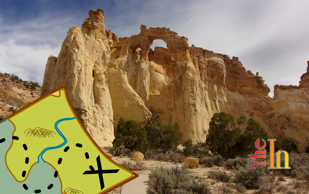
Natural arch aficionados probably have a favorite or two. Mine is Grosvenor Arch. This massive multicolor sandstone arch, actually a double arch, towers 150 feet above the ground with a main span of nearly 100 feet. To borrow a phrase, it is the mother of all arches. It is named in honor of Gilbert H. Grosvenor (1875–1966), a president of the National Geographic Society, publishers of the National Geographic Magazine.
Grosvenor Arch is in the northcentral section of the Grand Staircase-Escalante National Monument. The monument, shrunken drastically due to a presidential order in December 2017, now encompasses slightly more than one million acres of southcentral Utah. It is unique in that it is the first monument to be administered by the Bureau of Land Management rather than the National Park Service. The remote and pristine monument preserves a wealth of flora and fauna and Ancestral Puebloan (Anasazi) artifacts and home sites, not to mention a geological sampler with a huge variety of formations and features. Several hundred miles of roads (mostly dirt) provide public access to the many jewels of this area.
 This region of Grand Staircase-Escalante National Monument on the Colorado Plateau is classified as semi-desert. Plants and animals must adapt to the rather harsh environment. Wildlife includes deer, coyote, bobcats, grey foxes, rabbits, squirrels, chipmunks, snakes, mice, spiders, and the ever-present lizards.
 In late August, my wife Deb and I drove north from St. George on Interstate 15 and took Exit 57 (Main Street) at Cedar City. We continued north on Main Street for two miles until reaching University Boulevard/Center Street and turned right (east) onto Center Street/Highway 14. Highway 14 winds its way through the Markagunt Plateau of the Dixie National Forest for 40 miles and terminates at an intersection with Highway 89. We headed north on Highway 89 for 20 miles and turned right (east) at the State Route 12 intersection. Twenty-five miles later, we entered Cannonville. In Cannonville, we turned right (south), indicated by a large sign pointing to Kodachrome Basin State Park, onto Main Street. (On different maps the road to the park is indicated as Main Street or Cottonwood Road). We stayed on the main paved road and seven miles later (from the State Route 12 turnoff) passed the entrance to Kodachrome Basin State Park. Beyond this, Cottonwood Road is a good graded dirt road leading, after 9.1 miles from the Kodachrome entrance, to the signed Grosvenor Arch turnoff to the left (north). Another 0.9 miles on the access road brought us to the parking area and trailhead. Cottonwood Road, a great dirt road and assuming no recent rain, is passable for a standard vehicle.
We parked in the ample parking area, complete with restrooms and concrete picnic benches but no water, and headed toward the arches on the concrete (handicap accessible) “trail.” There are no fees or permits necessary for this hike.
 The trailhead elevation is 6,145 feet, and there is a 210-foot elevation change during the hike. The elevation change is deceptive: The walk to the arches is virtually flat. Almost all the gain in elevation is due to climbing the back of the ridge in which the arches are located.
It is about 0.1 mile to the arches, which become more inspiring the closer you get. The ridge containing the arches looks like a fairytale castle from a distance. The arches are 2/3 yellow with an orange top third. The gigantic rock bridge is jaw-droppingly impressive. We walked under the arches for a proper perspective and looked up into the Utah sky — quite a sight. There is an unmarked, but visible, trail at the end of the pavement. We went left, clockwise, and slowly climbed to the top of the ridge. Here, we were within a few feet of the arches and almost the same height — quite a view. It is about a 200-foot elevation gain in 0.3 of a mile — pretty steep. We continued in a loop around the entire ridge, enjoying views of all sides of the formation.
 It took us less than 1.5 hours to travel about 1.1 miles roundtrip. Almost as impressive as the arches was the silence — we saw no other hikers on our trek. You must get away from civilization and every tiny ambient noise to truly appreciate what silence means.
I highly recommend this adventure, especially for those who would rather not share a nature experience with hundreds of others. It is a bucket list experience for archphiles (I made up that word). The arches are quite a way from St. George. This is a perfect day trip to Grosvenor Arch and a visit to the nearby Kodachrome Basin State Park with rock colors living up to their name.
Articles related to “Hiking Southern Utah: Grosvenor Arch — You gotta see it to believe it”
Book Review: ‘Hiking Southwest Utah and Adjacent Areas: Volume One’ by Tom Garrison


