

Hiking Southern Utah: Third Ravine
Trail: Third Ravine
Location: Just south of Green Valley Gap (see Access below)
Difficulty: Moderate
Distance: Five miles
Average Time: Three hours
Elevation Gain: 700’
Third Ravine is an under-appreciated gem. Located on the plateau bordering western St. George, the trail is a wonderful example of the diverse terrain of Washington County. A narrow, rocky gorge choked with boulders and featuring some unique stone features leads to a cliff-lined terrace with two cave systems, followed by a brief climb to the top-of-the-world views of the mesa summit. On the return hike, a smaller and narrower but equally beautiful canyon (Second Ravine) descends back to the trailhead. Portions of the trail join with the Zen Trail, a world-class mountain biking trail.
Access: Take Dixie Drive to Canyon View Drive for three-quarters of a mile to where the road ends and Plantation Drive begins. Leave the pavement and follow the dirt road heading north. The road soon turns to the south, while a more major side road that leads to the Green Valley Gap heads west. Continue driving south until a power substation appears. Park in the pullout just before the station.
Step down into the wash below the car park, and pick up a faint trail near the west side of the power station. Follow this until the trail drops down into the mouth of the canyon (intersecting with the Zen Trail). Initially, the canyon is a shallow, slabby trough, but as the hike continues southwest, the gully deepens and widens. About a quarter-mile into the hike, Hole-In-The-Rock appears, a small opening in a hollowed-out stone. The rock here is composed primarily of the Shinarump conglomerate the makes up the area’s mesas and gullies.
 The trail winds around and past many boulders — both large and small — that have fallen from the rim of the ravine, creating a maze-like environment for portions of its length. Keep an eye out for an elephant-shaped small arch beside the trail. After about a mile and a half, the canyon opens up into a wide trough. Follow the trail south (it becomes occasionally faint through this section) until a series of switchbacks leading out of the bowl on the southeast slope of the trough.
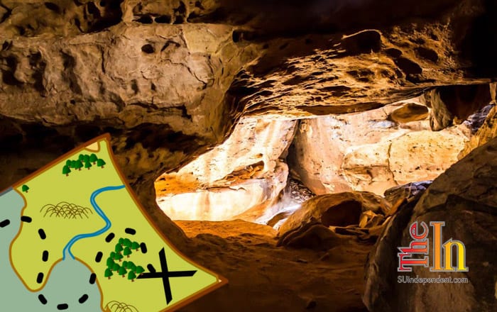
On the other side of the rim, a boulder-lined, shallow cirque appears. The Zen Trail cuts an obvious path along the base of this cirque, weaving south and east. Follow the trail towards the rim. In this short cliff, there are two caves. The first is the most difficult to find, hidden behind a boulder on the northwest side of the rim. Small tunnels can be crawled through to find open “rooms” in a series of passages, but be warned: these tubes are not for the claustrophobic, and bats may occasionally fly through them.
The second “cave” is on the western side of the cirque and is easier to find. In fact, it is actually a slot canyon in the making, with several large “rooms” to explore and narrow cracks to traverse. These tunnels are far less confining and make a great spot to stop and rest.
When finished exploring the caves, follows trails around to the southeast and pick up a scrambling trail out of and on top of the rim where it meets up with the Zen Trail. Follow this toward the west, where it rises gently to the summit of the mesa, marked by a three-foot-tall cairn. Superb mountain top views extend in every direction.
 To return, hike back down the Zen Trail in the direction you came and return to the cirque of the caves. Follow trails along the base of the cliffs that line the cirque, but do not return to the rim above the trough at the head of Third Ravine. Instead, continue hiking along the winding trail through slot canyons and boulder gardens of the Zen Trail, following the path northeast along the rim of the mesa. After approximately half a mile, a shallow canyon appears on the right. Follow faint trails into this chasm and enjoy spending the next mile scrambling, rock-hopping, and hiking through this picturesque slot. The last half mile the canyon fades into a shallow draw, which leads almost directly to the parking area.

