

Our National Parks and the Theory of Plate Tectonics
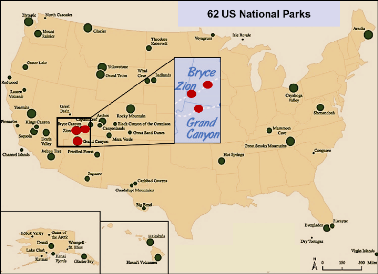
Our United States National Park Service (NPS) was established by the Federal Government in 1916. However, the oldest named National Park is Yellowstone, and it was signed into law by President Ulysses S. Grant in 1872. Currently, there are 62 such parks. A glance at a Park Service map clearly indicates a preponderance of what can be considered our natural treasures to be found in the western part of the United State, including Alaska and Hawaii. (Figure 1). Why is that?
the song Circle of Life (Elton John) from the Lion King: “There’s more to see than can ever be
seen”. Red dots are the three parks that will be discussed in this and the following articles.
Well, give thanks to a variety of geological processes related to plate tectonics that have been pushing and shoving rocks around the Earth’s surface for almost its entire 4.54-billion-year history. In our western area this activity, particularly that occurring during the past two billion years has generated the landscape we see today. Unfortunately, such activity has also obliterated a significant number of past events.
Plate Tectonics is a relatively new scientific theory for understanding how our planet works. Much evidence for this idea of how the Earth works was recognized in the early 1900s, but at that time no definitive proof was known for how it all worked. So, it was not until the mid-to-late 1960s that enough evidence was discovered to establish it as a valid theory. It has basically revolutionized how geologists view the Earth, perhaps like Charles Darwin’s ideas of Evolution was the key to revolutionizing how biologists view life on Earth.
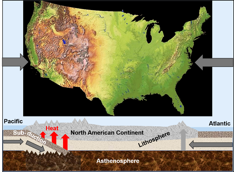
Plate tectonic activity In North America over the past 180 million years has generated a westward movement of what is termed the North American Lithospheric Plate. This has resulted in a collision with the Pacific Lithospheric Plate. The collision of these two plates has generated geologic processes termed subduction, uplift and deformation, and considerable igneous activity. Additionally, uplift of the western part of the continent has allowed erosion to do its work, which has resulted in exposing a wide variety of rocks and other geologic features which date back to almost 1.8 billion years ago (Figure 2). Rocks spectacularly exposed in three national parks discussed in these articles provide the evidence.
All this geologic activity is driven by energy. Physical and chemical events on and within the Earth are driven by two sources of heat energy, and they tend to counteract each other. The result is a geologically very active planet with the Earth’s surface as the interface between the two sources (Figure 3).
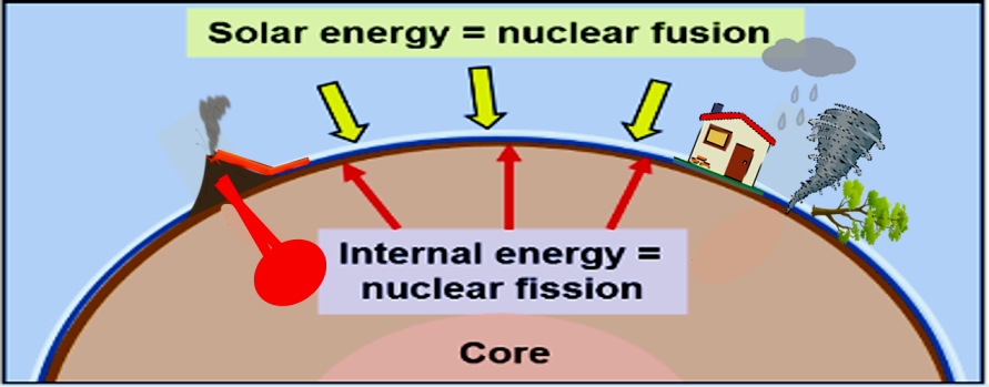
Earth’s surface is affected by solar energy, which drives processes such as weathering, erosion, climatic conditions and major storms. The surface is also affected by radioactive decay from the interior, which produces heat to drive processes such as volcanism, metamorphism, earthquakes, mountain building, and plate tectonics. Yup, the surface is quite an entertaining place to live.
The western United States contains much geologic evidence of this ongoing interaction between these two energy sources. Internal energy has produced abundant volcanism including the Yellowstone Caldera, extensive volcanic lava flows and locally the formation of the igneous rocks that make up Pine Valley Mountain. Numerous geologic faults and fault systems cut the region and that results in common and sometimes major earthquakes. Uplifted and deformed mountain ranges are common throughout the region.
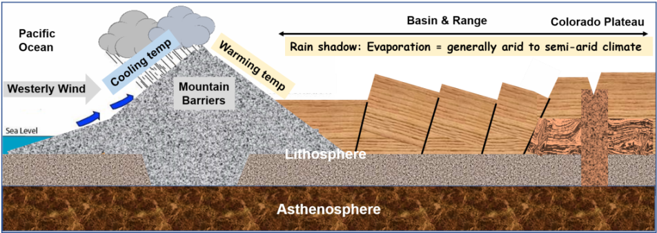
The heat from solar energy at the surface has produced visual evidence of the long-term power of weathering and erosion. The fact that this is occurring in arid and semi-arid climates of this region has resulted in the formation of some spectacular scenery that is mostly exposed rather than covered by plants (Figure 4). Hence, there is the stark exposed beauty of all these National Parks and Monuments and State Parks. Overall lack of dense plant life has helped to accentuate the beauty of the region.
I have to admit, however, that during a vacation restaurant stop in Green River, Utah a few years ago I overheard a person at a nearby table complaining to the people he was with: “When are we getting out of this God-forsaken area.” Beauty is in the eye of the beholder, eh?
Where Are We?
Geologically, St. George is located near the western edge of the Colorado Plateau Geologic Province. The boundary of this province with the Basin and Range Province to the west is marked by a major fault system.
In central and northern Utah this is known as the Wasatch Fault System and it extends northeastward into Idaho. To the east, the Colorado Plateau abruptly terminates in a complex boundary with the Rocky Mountain Province in western New Mexico, Colorado, Idaho and farther northward into southern Canada (Figure 5).
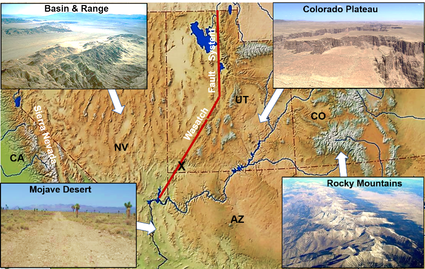
This fault system also extends into southwestern Utah and northeastern Arizona. It is evident when driving through the Virgin River Gorge on Interstate 15 at about Arizona mile marker 18 where there is an abrupt change in color, orientation, and age of the rocks (Figure 6).
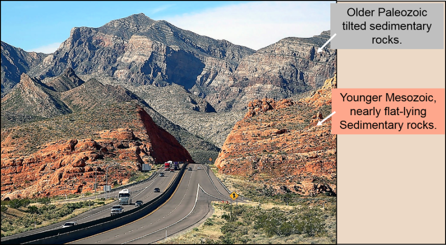
Rocks exposed in the Virgin River Gorge provide an easily accessible and a quick summary of what changes occur between the Colorado Plateau to the east and the Basin and Range to the west. Geologically older tilted brown and gray weathering rocks in the lower portion of the Gorge are more typical of what occurs in mountain ranges of southern Nevada and southeastern California. Examples are the Spring Mountains just west of Las Vegas, Nevada and the various ranges in and around Death Valley, California such as the Panamint Range and Funeral Mountains.
In contrast, are the nearly flat-lying brown and red weathering rocks in the upper portion of the Gorge. They are more typical of what can be seen in the middle and upper portions of the Grand Canyon and other areas of the Colorado Plateau.
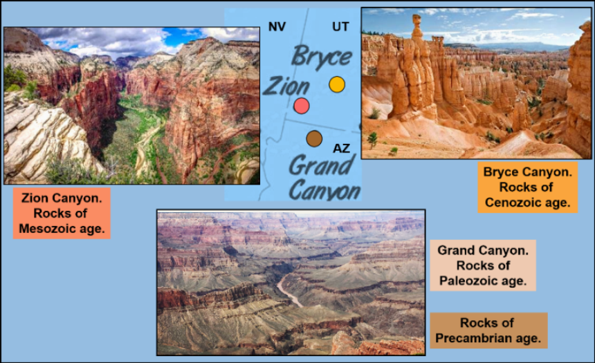
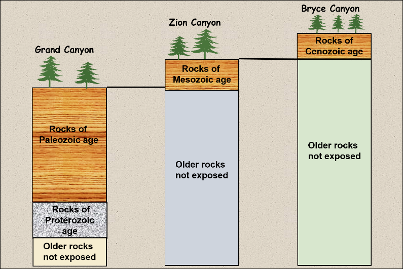
Although there are many national parks in this region, there are three located within a short drive from the City which are the focus of this series of articles. These three parks include the Grand Canyon, Zion Canyon, and Bryce Canyon. Within these three geographically close parks is a beautifully exposed but incomplete succession of rocks that span about 40 percent of the Earth’s history. This unusual area, therefore, provides a rare and very spectacular view of a significant portion of geologic history (Figure 7).
Geologic Principles to Consider
Geologic ages of the rocks and their relationships among these three parks have been determined by various geologic principles and techniques. These principles and techniques are basic to the geological sciences and some were recognized as far back as the mid-1600s.
1. Recognition of the succession of sedimentary rocks at all three parks is based on a long-established principle known as “The Law of Superposition”. This law demonstrates that overlying rocks must be geologically younger than underlying rocks. This concept was initially proposed in 1669 by Nicholas Steno.
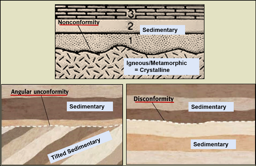
2. Recognition of unconformities within the rock record. Essentially these represent missing rock records, like chapters missing from a poorly printed book First described in the late 1700s by James Hutton, there are three main types (Figure 8). Of interest, is that it occurred to Hutton after studying his unconformity, just how immense geologic time might be. His statement: “…no vestige of a beginning, no prospect of an end.”
3. A wide variety of fossilized microfossils, invertebrates, plants, vertebrates, and trace fossils have been found and identified in the sedimentary rocks of all three parks. These fossils demonstrate a distinct succession from oldest to youngest and are used to establish the relative ages of the rocks. They are also used to provide evidence for the ancient environments in which they lived and died. This technique was first proposed as ‘faunal succession” by William Smith about two hundred years ago in the early years of the 19th century.
4. By using known ages of the fossils preserved in these rocks, and to a lesser degree the physical characteristics such as color and composition of the rocks themselves, these rocks have been matched up from park to park. This technique is termed geologic age correlation, and it is a principle that has become firmly established since the time of Charles Lyell in the 1830s. It has been applied to rocks on all continents (Figure 9).
5. Radiometric ages have been determined for igneous and metamorphic rocks exposed in the inner gorge of the Grand Canyon. This dating method was established in the early 1900s. By the mid, to late 1950s it had become very accurate as technical accuracy of machines used to determine these dates improved. It has also been applied to rocks making up the floors of the ocean basins and those exposed on all continental land areas. It is one of the important methods used to track plate tectonic activity.
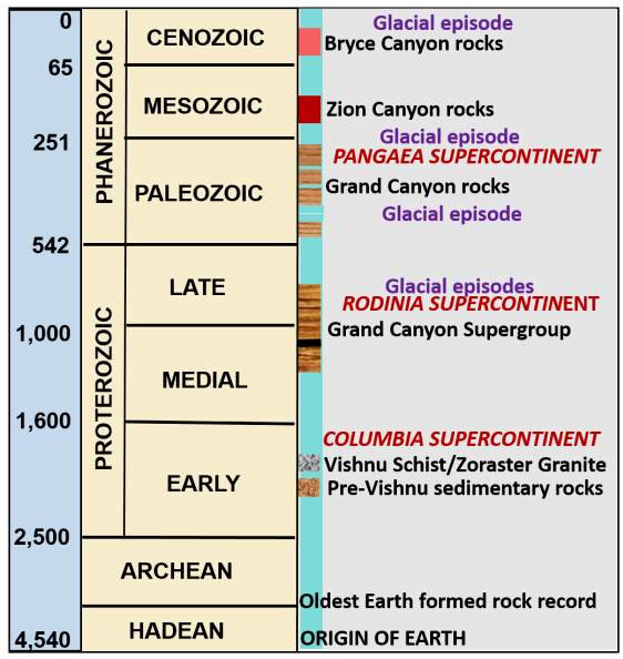
6. Since 1869 combined research from a variety of geologic disciplines have been applied to the rocks of these three national parks and surrounding regions. Accumulated evidence has continuously been incorporated into a time framework for the region. Some of this is summarized in (Figure 10) and will be referred to in succeeding articles.
A final thought is the immense amount of time represented by the nearly two-billion-year record of rocks exposed in these three parks; truly it represents “deep time”. It is difficult to visualize such an enormous passage, even for geologists, as our conceptual awareness of time operates in tiny increments such as weeks, months or years. However, the proximity of these parks allows us to observe and hopefully interpret these ancient events of Earth’s history that have occurred over this vast passing of ages.


 was established by the Federal Government in 1916. However, the oldest named National Park is Yellowstone)