Our Geological Wonderland: “Don’t build on blue clay!” In southern Utah, Blue clay primarily occurs within the upper member of the Chinle Formation.

Our Geological Wonderland: Blue clay

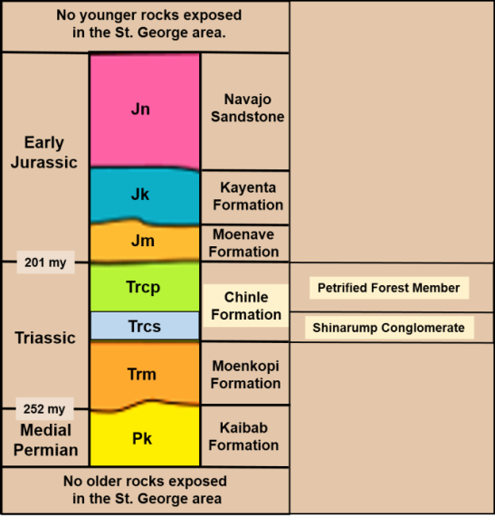
Making things out of clay in a ceramics class is fun and creative. In contrast, “Don’t build on blue clay!” is a common phrase heard in southern Utah. And for good reason, as this particular clay is unstable and the cause of a number of slumps and slides that have damaged or destroyed roads and buildings around the city and adjoining areas. From a geologic perspective, our blue clay has an interesting history that extends back in geologic time to the Triassic Period, a little over 200 million years ago (Figure 1). Blue clay primarily occurs within the upper member of the Chinle Formation. This member, known as the Petrified Forest Member, received its name from exposures at Petrified Forest National Park in northern Arizona.

Our Geological Wonderland: “Don’t build on blue clay!” In southern Utah, Blue clay primarily occurs within the upper member of the Chinle Formation.
Figure 1. Rock formations and their geologic ages in the St. George area. Blue clay occurs within the Petrified Forest Member of the Chinle Formation. Irregular lines between rock units indicate missing rock record (unconformities).

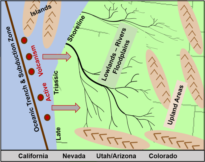
The Chinle Formation consists of a variety of different sedimentary rock types including conglomerate, sandstone, siltstone, mudstone, and clay. Within the St. George area, the formation is divided into only two members. But in other areas, additional members have been recognized and named. Chinle sediments initially formed in ancient Late Triassic environments such as rivers, floodplains, and lakes, which were widespread in what is now the southwestern part of the United States (Figure 2). To the east and south were low-lying upland areas, which were undergoing weathering and erosion and provided the source for most of the mud, silt, sand, and pebbles along with some clay minerals that were deposited in these environments. To the west, where dry lands of western Nevada and California are today, was ocean during that same interval of time,

Our Geological Wonderland: “Don’t build on blue clay!” In southern Utah, Blue clay primarily occurs within the upper member of the Chinle Formation.
Figure 2. Simplified paleogeographic map of the western United States during Late Triassic time, 201–210 million years ago. What was to become the North American Continent was just beginning to move westward as the supercontinent known as Pangaea began to split apart, thereby generating a collision with the Pacific Ocean lithosphere. This resulted in subduction, earthquakes, and volcanic activity. Prevailing winds (gray arrows) blew some volcanic ash eastward into Utah and Arizona.

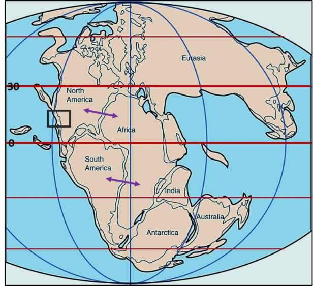
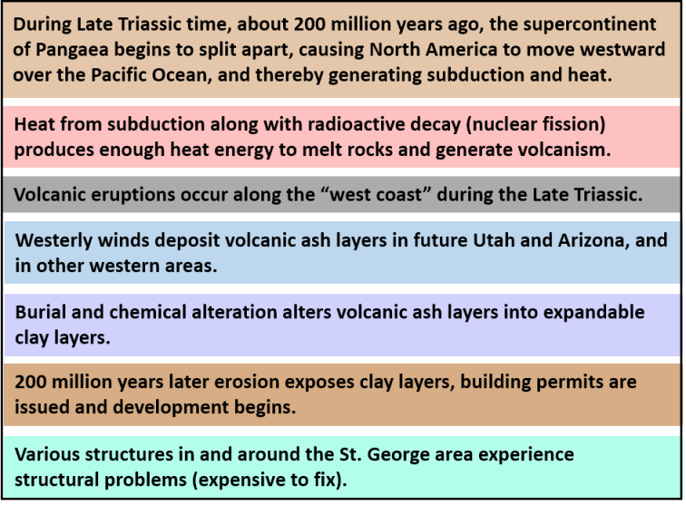
During Triassic time, most of the present continents were combined into a single landmass, a supercontinent, which was given the name Pangaea a little over 100 years ago and which had formed between 250 and 300 million years ago. By Late Triassic and Early Jurassic time (201–180 million years ago), Pangaea had begun to split apart, with North America beginning to move westward (Figure 3). Thus, what was then the western edge of the continent became what is known as a “leading edge,” and therefore it began to be affected by tectonic activity such as uplift and volcanism. By Cretaceous time, about 120 million years ago, this region was very active and perhaps resembled what is today the Cascade Range volcanic chain.

Our Geological Wonderland: “Don’t build on blue clay!” In southern Utah, Blue clay primarily occurs within the upper member of the Chinle Formation.
Figure 3. World map of the supercontinent Pangaea during Triassic time (252–201 million years ago). Note location of the area discussed below (black rectangle), which at that time was located between 15 and 20 degrees north of the equator. By Late Triassic time, when the Chinle sediments and volcanic ash were being deposited, North America and South America had begun to split apart from Europe (Eurasia) and Africa (purple arrows). One result of this split was the beginning of the formation of the Atlantic Ocean.

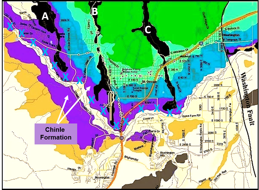
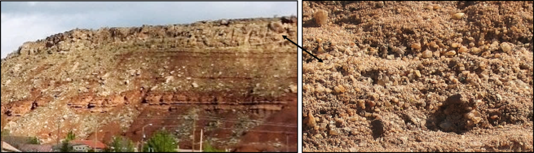
As indicted on a geologic map below, rocks that make up the Chinle Formation are exposed in an arcuate pattern within the St. George area (Figure 4). The most distinctive part of the formation is the Shinarump Conglomerate member because it is hard and resistant to erosion, and so it tends to form ridge tops in the area. The size of the pebbles and their generally rounded outlines indicate they were transported by relatively strong water currents and that they were transported a significant distance from their original source by rivers (Figure 5).

Our Geological Wonderland: “Don’t build on blue clay!” In southern Utah, Blue clay primarily occurs within the upper member of the Chinle Formation.
Figure 4. Geologic map of the St. George City area. Locaton of the Chinle Formation is indicated by purple color on the map. Blue clay (“X”) occurs in the upper part of the Chinle Formation (Petrified Forest Member), which gets its name from the same rocks at Petrified Forest National Park in Arizona. Black “fingers” on the geologic map are basalt lava ridges in St. George (Our Geological Wonderland: The Famous Inverted Topography of Basalt Lava Ridges of St. George. The Independent 04/08/18). A = West Ridge; B = Black Ridge; C = Middleton (Foremaster) Ridge.
Our Geological Wonderland: “Don’t build on blue clay!” In southern Utah, Blue clay primarily occurs within the upper member of the Chinle Formation.
Figure 5. Exposure of the Shinarump Conglomerate Member of the Chinle Formation (black arrow), which overlies the reddish-brown layers of the Moenkopi Formation. Left: Image taken from River Road just south of Stone Cliff. Right: Closeup image of pebbles within the Shinarump indicating that most are similar in size and they are generally rounded in outline.

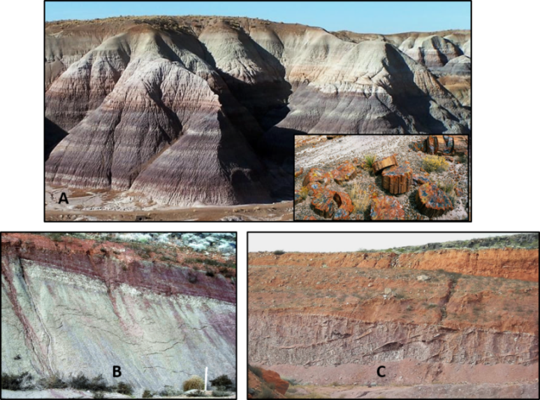
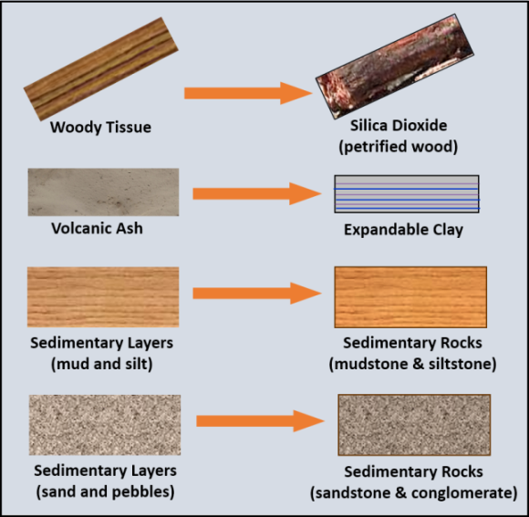
Rocks overlying the Shinarump Conglomerate collectively make up the Petrified Forest Member of the Chinle. They consist of layers of variable colored fine-grained rocks such as siltstones, mudstones, and clay. Also found in this member are fossil remains of trees in the form of silica-replaced petrified logs (Figure 6). As indicated in Figure 2, these sediments originally formed in a variety of warm climate environments such as rivers, floodplains, lakes, and ponds. Additionally, layers of volcanic ash were blown in from the west and deposited with the other sediments.

Our Geological Wonderland: “Don’t build on blue clay!” In southern Utah, Blue clay primarily occurs within the upper member of the Chinle Formation.
Figure 6. Exposures of the Petrified Forest Member of the Chinle Formation. A. Petrified Forest National Park, Arizona. Note fossils of petrified wood (inset). B. Weathered and eroding blue clay in road cut at the south end of Middleton (Foremaster) Ridge, and C. Blue clay exposed at the south east side of Black Ridge.

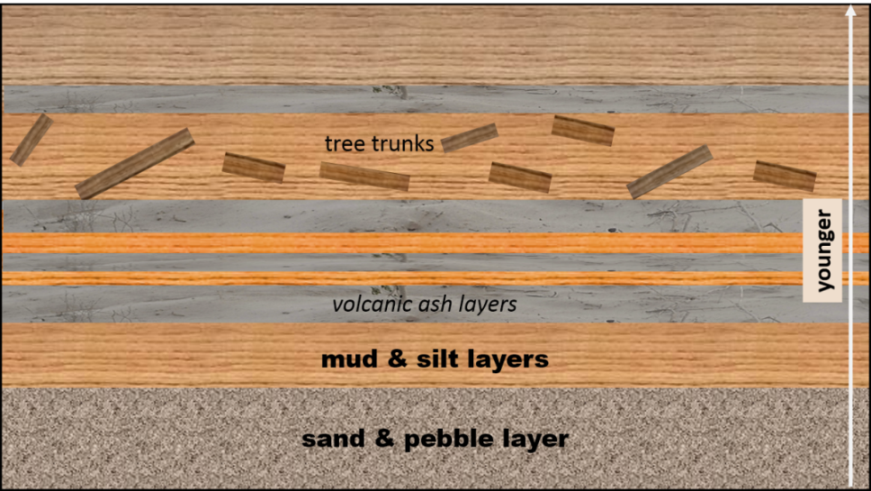
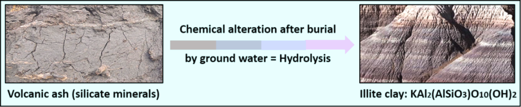
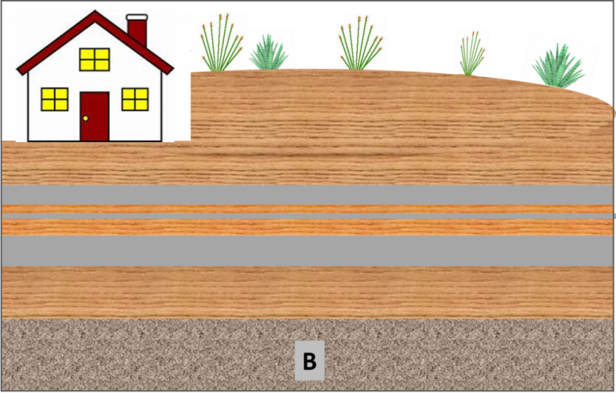
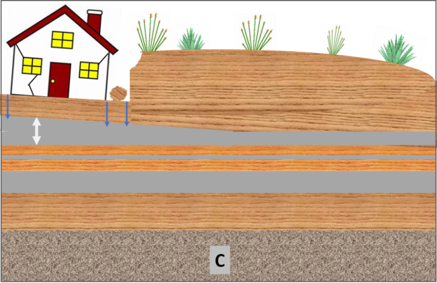
A model illustrating deposition of these sediments and volcanic ash is illustrated by Figure 7. Subsequent to their deposition and burial, various types of physical and chemical alterations occurred (Figure 8). The resulting rocks which formed from these changes are now known as the Chinle Formation (Figure 9).

Our Geological Wonderland: “Don’t build on blue clay!” In southern Utah, Blue clay primarily occurs within the upper member of the Chinle Formation.
Figure 7. Deposition of various sediments representing low-lying river and floodplain environments, in a warm and moderate climate during Late Triassic time. This is representative of southern Utah and northern Arizona.
Our Geological Wonderland: “Don’t build on blue clay!” In southern Utah, Blue clay primarily occurs within the upper member of the Chinle Formation.
Figure 8. Various types of alteration occurred after burial of sediments and organic material. With the presence of sub-surface water (groundwater) that contains various chemical ions in solution, sediments are lithified (cemented) into rocks. Volcanic ash is chemically altered to blue clay (Figure 10). Woody tissue is chemically replaced by silica dioxide (SiO2) to form petrified wood.
Our Geological Wonderland: “Don’t build on blue clay!” In southern Utah, Blue clay primarily occurs within the upper member of the Chinle Formation.
Figure 9. This succession of rocks has been named the Chinle Formation. In the St. George area, this formation consists of two members, a lower Shinarump Conglomerate and an upper Petrified Forest Member. Blue clay occurs within the Petrified Forest Member.
Our Geological Wonderland: “Don’t build on blue clay!” In southern Utah, Blue clay primarily occurs within the upper member of the Chinle Formation.
Figure 10. Volcanic ash, which consists of a variety of silicate minerals, can be altered by a chemical process termed hydrolysis, which usually occurs after burial by mineralized groundwater. The end product is a clay mineral, of which there are a number of types. The blue clay in St. George is a type of illite/smectite, which is an expandable clay; therefore, it absorbs water and expands.

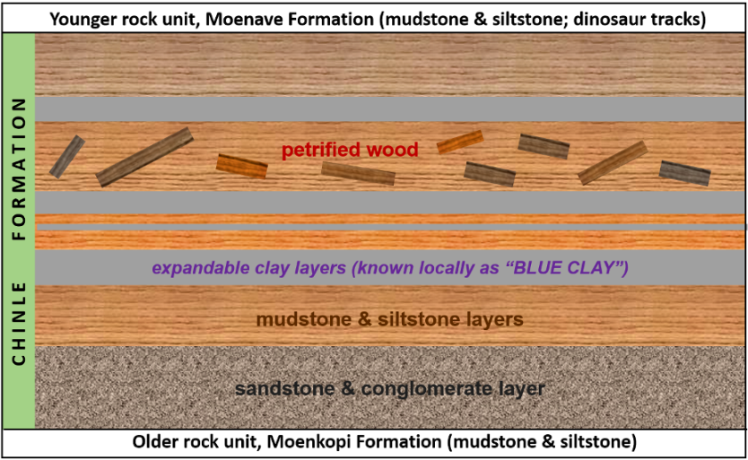
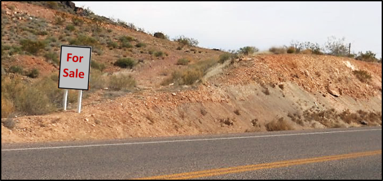
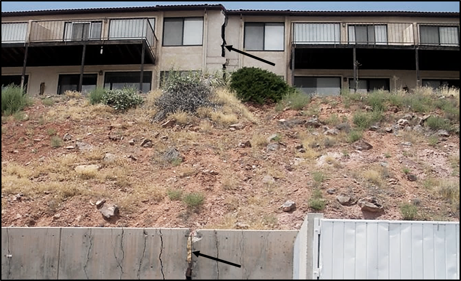
As noted in Figure 4, in the St. George area blue clay within the Petrified Forest Member is exposed in an arc-like pattern. The entire Chinle Formation is tilted so that as you progress northward, it dips deeper below the surface. Therefore, it is mostly where the clay is exposed or very close to the surface that there are potential hazards in terms of slides, slumps, and damage to structures (Figure 11).Our Geological Wonderland: “Don’t build on blue clay!” In southern Utah, Blue clay primarily occurs within the upper member of the Chinle Formation.

Our Geological Wonderland: “Don’t build on blue clay!” In southern Utah, Blue clay primarily occurs within the upper member of the Chinle Formation.

Our Geological Wonderland: “Don’t build on blue clay!” In southern Utah, Blue clay primarily occurs within the upper member of the Chinle Formation.
Figure 11. Blue clay effects. Note that these diagrams simplify the rocks as being horizontal, although they are actually tilted. A. Original weathered hill with the Chinle Formation. B. Part of hill cut and graded, and a home is built on the graded surface. C. Water seeps in from rain, watering of lawns and plants, etc. (blue arrows). The blue clay layer absorbs water, expands (white arrow), and tilts and cracks walls and foundation of the home. A boulder is dislodged from cut.

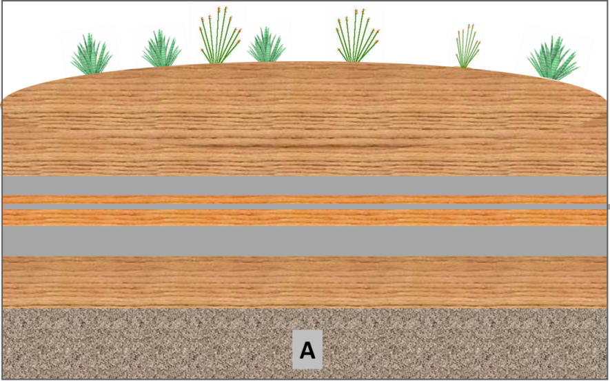
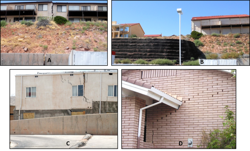
Examples of damage to structures in St. George (Figure 12). Some structures can be repaired, but others must be demolished, such as the condominium unit and the Knights Inn Motel. Building on blue clay is risky, but engineering techniques can be used to minimize or eliminate potential problems (Figure 13), although there is a significant cost to do so. A very worthwhile idea would be to hire a registered geologist to examine any property before it is purchased. Moral: Modest up-front expenses may save large future expenses.

Our Geological Wonderland: “Don’t build on blue clay!” In southern Utah, Blue clay primarily occurs within the upper member of the Chinle Formation.
Figure 12. Damage to structures related to blue clay. A & B Before and after slump damage to condominium units on Bluff Street behind the Dairy Queen (note same dark green bush near upper center of both images). D. Side view of Knights Inn Motel from Dairy Queen parking lot. Images A and C from July 2011. Image B from 2017 after removal of damaged condo unit. D. Damage to home in the Santa Clara area.

Historic geologic events that have played a role in the formation of blue clay are described in Table 1.

Our Geological Wonderland: “Don’t build on blue clay!” In southern Utah, Blue clay primarily occurs within the upper member of the Chinle Formation.
Table 1. A summary of over 200 million years of geologic history to explain blue clay in Washington County.
Our Geological Wonderland: “Don’t build on blue clay!” In southern Utah, Blue clay primarily occurs within the upper member of the Chinle Formation.
Figure 13. The end!

I thank Janice Hayden, professor at DSU, and Andrew Rupke and Lance Weaver of the Utah Geological Survey for suggesting some ideas and providing reference material for this article.

Articles related to “Our Geological Wonderland: Blue clay”

Our Geological Wonderland: Quail Lake and the Virgin Anticline

Our Geological Wonderland: Dinosaur Discovery Site at Johnson Farm

Our Geological Wonderland: A trip through the Virgin River Gorge

Click This Ad

1 COMMENT

  1. Great article. I live in a blue clay zone, and fortunately the foundation of my house has remained intact for over 30 years. However I was digging post holes in my backyard and discovered blue clay about 3′ down. Fortunately it is way in the backyard 30’+ from the house. I would call it purple clay. The local church near my house is famous for the original foundation crumbling due to blue clay deposits. The neighbor across the street had their foundation rebuilt due to blue clay a year or so after the house was built in the late 80s. All I can say is buyer beware.

LEAVE A REPLY

Please enter your comment!
Please enter your name here