

Our Geological Wonderland: Volcanoes in southern Utah
Remnants of volcanoes in southern Utah and of previous volcanic activity are numerous and quite evident. Among them are volcanic features like cinder cones and lava flows, most of which have formed within the last six million years and some even within the past 30,000 years. It is certainly possible that another eruption could occur in the future, and wouldn’t that be exciting? Various other types of igneous activity, however, have been occurring in this region for at least the past 36 million years of geologic history. Also, we recognize the Pine Valley Mountain igneous intrusion, which formed about 22 million years ago. Let’s chronicle these intense geological events.
Supervolcanoes
A group of geologists from BYU published results of a long-term study indicating that supervolcanoes, like those in the modern-day Yellowstone area, produced very extensive eruptions in this region from about 18–36 million years ago (Figure 1). Much of the obvious evidence for these eruptions has been eroded away or covered by younger sediments, but remnants of a distinctive rock type, known as ignimbrite (welded volcanic tuff) provide clues to the extent and duration of these eruptions. Fortunately, these volcanic rocks can be radiometrically dated, thus providing the numerical ages of the eruptions.
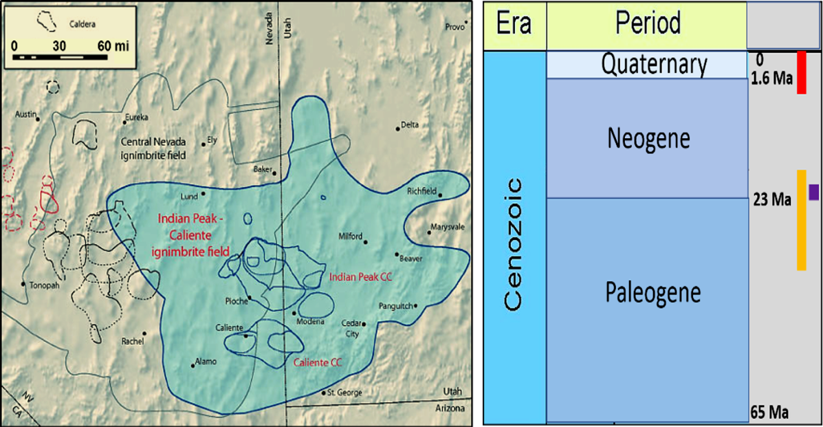
Right. Portion of the Geologic Time Scale which indicates the time interval of the supervolcano eruptions (orange) and other events such as formation of Pine Valley Mountain (purple) and more recent volcanism (bright red). “Ma” stands for “million years.”
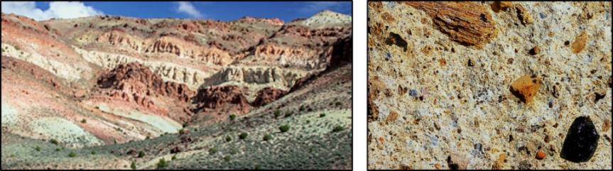
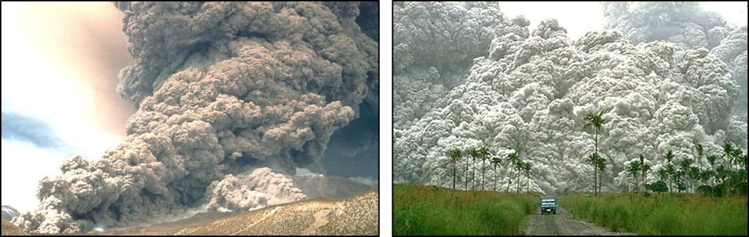
Within this supervolcano field are some preserved rocks that provide a record of the eruptions. Most common are layered volcanic rocks, which occur in a variety of colors and represent successive eruptions. These rocks are a well cemented, or welded, fine-grained volcanic ash, which contains larger volcanic fragments (Figure 2). Modern eruptions that produce such rocks can be very explosive and consist of very hot ash and cinders, other rock fragments, and hot gases, all of which travel downslope from the volcanic source as a very hot, quickly moving flow, much like an avalanche. Such an eruption and flow is termed a “nuee ardente” (Figure 3).
Pine Valley Mountain
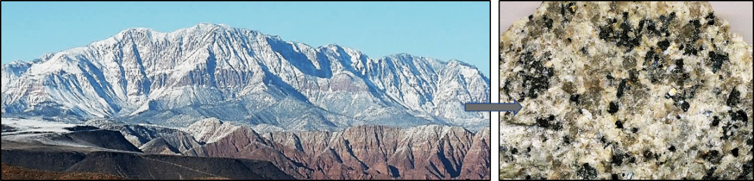
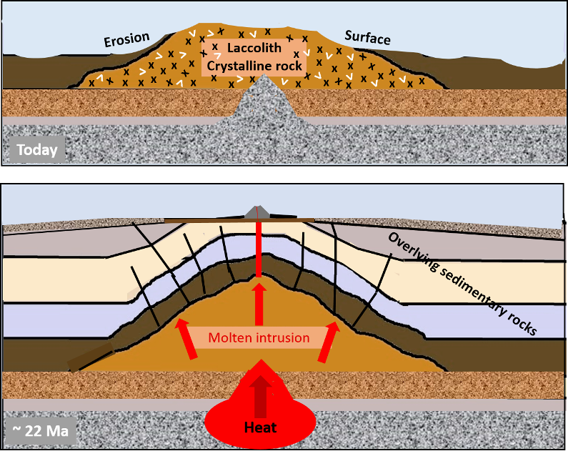
A very distinctive feature recognizable to residents in the St. George area is Pine Valley Mountain. The mountain represents a geologic feature called a laccolith, which is an intrusive igneous mass with a distinctive dome-like shape. A laccolith forms below the surface as molten magma pushes up into overlying rocks and then slowly cool and crystallizes. The resulting rocks are identified as a quartz monzonite. The monzonite of Pine Valley Mountain has been radiometrically dated as having crystallized about 22 million years ago (Figures1, 4, and 5). This subsurface dome-shaped structure was subsequently exposed by weathering and erosion, which removed the overlying sedimentary rocks. This laccolith is one of the largest in the world and reaches elevations of over 10,000 feet.
More recent history
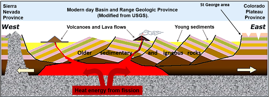
As noted above (Figure 1), significant volcanic activity of a much younger geologic age has also occurred in this region. Because of their relatively young geologic age, many of these features are still present. Volcanic cinder cones and lava flows can be seen within Washington County and even within the city of St. George. This volcanic activity is a result of two significant geologic activities. One is the continuing plate tectonic activity along the western edge of North America and the other is a process of extension of the outer lithosphere layer of the Earth between western Utah and eastern California. These activities generate heat and stress on the rocks and a thinning of the lithosphere.
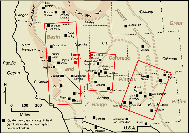
Regionally, some of the landscape and geologic features resulting from these activities include the Cascade Volcanic Arc, the San Andreas and associated faults, the north trending mountain ranges and valleys that make up the Basin and Range Province, the north trending fault zone called the Intermountain Seismic Belt in Utah, the succession of Yellowstone calderas, and numerous volcanic cones and lava flows in Nevada, northern Arizona, and Utah (Figure 6).
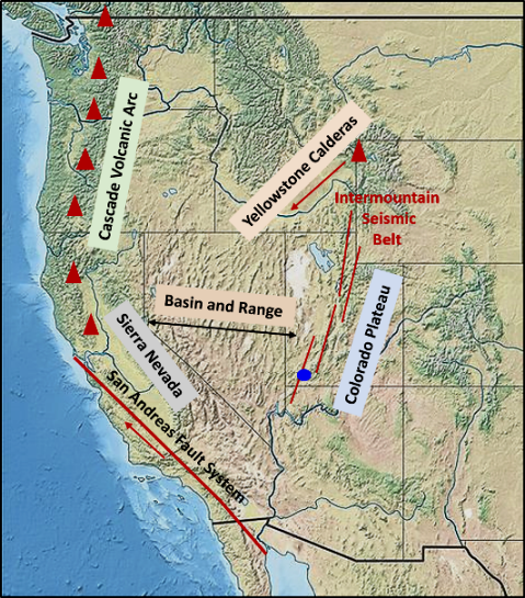
St. George is essentially located within a transition zone between two geologic provinces, the Basin and Range to the west and the Colorado Plateau to the east (Figure 7). The city lies within a widespread volcanically active region which includes northern Arizona and southwestern Utah (Figure 8).
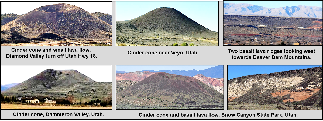
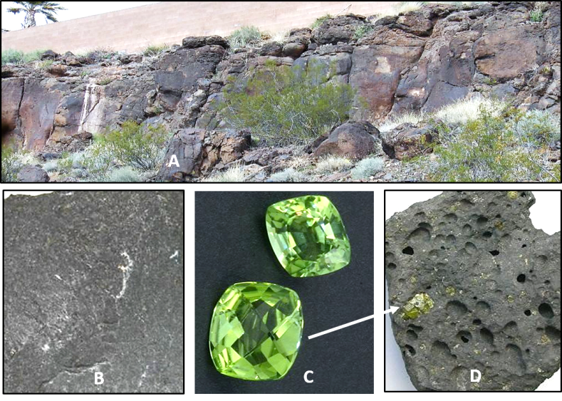
In Washington County, evidence of this geologically young volcanism is common and seems to be considered “just part of the landscape” by most residents. There are numerous volcanic cinder cones, which consist mostly of ash and cinders (Figure 9). The fact that they are still evident and have not been eroded away indicates they are geologically young features.
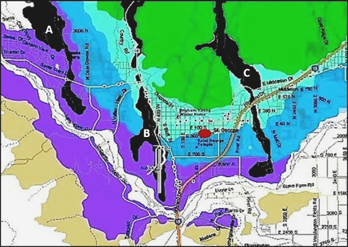
A distinctive volcanic feature within the city are nearly flat-topped ridges, which are capped by lava flows that consist mostly of a rock called basalt. There are three prominent ridges that can be readily seen from almost anywhere in the city and also show up as distinct features on a geologic map of the city (Figures 9 & 10).
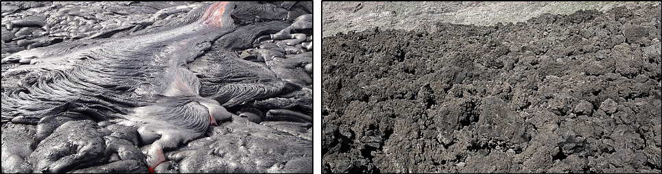
The surface texture of these lava flows is also distinctive. Two main types are recognized by geologists, and they have been given Polynesian names (Figure 11). The basalt itself is a distinctive igneous rock (Figure 12). Although these flows formed on the continent, basalt is the most common rock type forming the floors of the ocean basins (think Hawaiian Islands).
The future
Previously occurring widespread but episodic igneous activity is recognizable in a variety of geologic features in Washington County and surrounding areas of the southwestern United States within the past six million years. Within the St. George area, the most recent eruptions occurred approximately 30,000 years ago.
This brings up the question: Will there be another eruption, and if so, when might that occur?
The answer is that we don’t know. However, there is one clue. There are active hot springs within the area, such as Pah Tempe in Hurricane and the Veyo hot springs. So there is still a source producing heat below the surface.
But is it enough to generate another volcanic eruption? Stay tuned.
And finally, as is sometimes reported but possibly representing an urban legend, in ancient times, especially in the New World, sacrificing a human was used to protect people from volcanic eruptions and also to protect against other naturally occurring geologic hazards.
“Bring forth the sacrificial!”
Articles related to “Our Geological Wonderland: Volcanoes in southern Utah”
Our Geological Wonderland: The Pine Valley Mountain Laccolith
The famous inverted topography of basalt lava ridges of St. George


Thank you for the timely and informed article. Coincidentally, or not, the USGS very recently released an addendum to a 2005 report on the most significant volcanic hazards in the United States. In 2005 the Santa Clara volcanic field was included in the report. The 2018 addendum drops the Santa Clara volcanic field completely. I looked online and it appears that information about the SC volcanic field has been carefully scrubbed of any information that indicates that there may be a hazard. I suppose that the developers who built on the lava flows and the people who bought homes in the hazard zone, such as Diamond Valley, might be upset if insurers raised rates or dropped coverage altogether. Thanks again. Well done.