
Top 10 uncrowded hikes in southern Utah
Red Mountain Traverse

Red Mountain Traverse is located primarily in the Red Mountain Wilderness area, along the edge of Snow Canyon State Park. It extends from the Ivins trailhead. This is a strenuous hike that consists of a steep climb, backcountry area with no trail, almost no shade, and a very long distance of about 10 miles. Hikers should remember to arrange transportation to shuttle them back to the starting trailhead after finishing. As it is easy to get lost, hikers should also be sure to study maps and bring a GPS or an experienced guide. Overall, the hike is a lot of fun but very exhausting. It’s the type of hike that every hiker in St. George should try to do at least once. The views of Snow Canyon and the surrounding area are spectacular and worth the long trek.
For a full hike description, click here.

Chinle Trail
Chinle Trail, located outside of the main tourist areas of Zion National Park, is an off-the-beaten-path trail located in the lower-elevation west-desert wilderness area. Though it’s a long, 15.4 mile roundtrip trail, it’s a mellow hike. Plus, it’s great for kids because it’s not treacherous, slippery, or steep. The Chinle trailhead is outside of Zion, south of Springdale. Hikers will be graced with views of the West Temple, Mt. Kinesava, Towers of the Virgin, and Sundial. The greatest part about this trail is that it offers quiet solitude, peace, exercise, and mental rejuvenation. Anyone who intends to do this hike in one day should be mindful of running out of daylight. It’s wise to bring a headlamp just in case.
For a full hike description, click here.

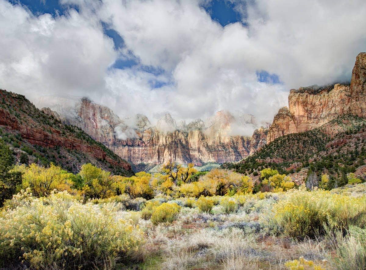
Big Hollow
Three Peaks is an obscure mountain located near Stoddard Mountain between Enterprise and Cedar City. While not quite as high as neighboring Stoddard, it is a much more rugged, rocky mountain by comparison and provides interesting climbing. The traverse from south to north takes the sojourner over numerous rock crags and the three highest horns of the mountain. The hike begins on an increasingly narrow road until you come to the sign for the Big Hollow Trail. It’s helpful to use the smaller peaks lower on the mountain as route-finding guides. A GPS is also useful.
For a full hike description, click here.

Mill Canyon Trail
The Mill Canyon Trail is a spectacular hike in the Pine Valley Mountain Wilderness that leads through a narrow canyon lined with towering crags, a rich forest of fir and aspen, and a seasonal stream. It’s a strenuous, 10-mile roundtrip hike that leads to the isolated corner of the Pine Valley Mountains. The trail is easy to follow and maintains a fairly even pace of ascent. Hiking in the Pine Valley Mountains is a completely different experience than the nearby desert. Mill Flats featured a grassy meadow with a small stream running through its center. The aspens are a brilliant splash of color in the fall, and the craggy splendor of the surrounding peaks makes this a spot at which one wants to linger for a long time. Several trails branch out from here, allowing for a multi-day exploration of the vast Pine Valley Mountains.
For a full hike description, click here.

South Boundary Trail
Pine Park is a long-forgotten wonderland of white volcanic pinnacles and cones located in a veritable wilderness west of Enterprise. South Boundary Trail is a long but easy hike away from civilization. It’s recommended to just explore the lower reaches of the trail around the park itself. Even though Pine Park is only 20 or so miles from Enterprise, it is a remote place. This particular spot is an awe-inspiring and spectacular place to explore and contemplate the forces of nature and the wild beauty of Utah. Hikers should be sure to let someone know where they are going and should ensure that vehicles are in good operating condition with at least one functioning spare tire.
For a full hike description, click here.
 The Maze

The Maze is a scenic, intriguing, entertaining, and easily accessible off-the-radar hiking spot. While the overall hike itself is fairly easy, route-finding can be challenging. The path starts out with a steep pitch of switchbacks and bare stone, drops into a magical slot canyon, and optionally ascends onto the southern end of the tall plateau with stately views towards the northern side of the Red Mountain Wilderness. This hike gives lovely views of Signal Peak and the Pine Valley Mountains. Caution should be exercised in certain sections, as social trails sometimes cut right through large patches of cryptobiotic soil.
For a full hike description, click here.
 Spectra Point Trail

Cedar Breaks National Monument, which lies east of Cedar City, is a welcome refuge of cooler summer temperatures for heat-weary residents of the desert lowland. With a fraction of the visitors who swarm Zion in summer, Cedar Breaks is a quieter destination that has a grandeur similar to the national parks the region is famous for. The Spectra Point Trail is an ideal hike for families and those wanting to quickly take in the awesome splendor of this unique place. The trail along the rim is well-graded and fairly wide, and the uphill sections are minimal. Since the rim of Cedar Breaks is well above 10,000 feet, altitude sickness is a very real possibility here. Hikers should pay attention to each member of the hiking party and not press on if anyone begins to feel ill.
For a full hike description, click here.
 Kayenta Hellhole

Hellhole Canyon, located at the edge of the Kayenta subdivision west of Ivins, is a superb, easy-to-reach canyon of towering rock walls well worth a few hours of hiking. While the route can be sandy and a bit laborious, it gains very little elevation and presents few obstacles for families with children. It is advisable to start as early as possible to end the hike before the heat of the day becomes too withering. This trail has very little shade. Despite being so close to civilization, this is a quiet, peaceful place to wander. With the limitations on parking, there are rarely more than a few groups in the canyon at any time. Hikers will enjoy the quiet majesty of the canyon, hearing more canyon wrens than human voices. Experienced scramblers will delight in exploring the upper stretches of the ravine.
For a full hike description, click here.
 Third Ravine

Third Ravine is an underappreciated gem. Located on the plateau bordering western St. George, the trail is a wonderful example of the diverse terrain of Washington County. A narrow, rocky gorge choked with boulders and featuring unique stone features leads to a cliff-lined terrace with two cave systems. This is followed by a brief climb to the top-of-the-world views of the mesa summit. On the return hike, a smaller and narrower but equally beautiful canyon — Second Ravine — descends back to the trailhead. Portions of the trail join with the Zen Trail.
For a full hike description, click here.
 Shivwits Arch

The Virgin River Gorge has beautiful views that most people just observe as they drive through it on their way to somewhere else. Not many people think of it as a place to stop and hike. While technically not in southern Utah, the hike up to Shivwits Arch is reached by a short drive partway down the gorge. There are several paths to choose from to reach the Arch. The hike is not long, but it’s difficult due to the elevation gain and trail conditions. It involves some route-finding and quite a bit of boulder-hopping. There are a few places near the opening of the Arch where stemming is required. This is a canyoneering technique that involves placing one’s back against one side of a canyon wall, putting one’s feet across to the other side, and working one’s way up. The trail gains about 900 feet in elevation in the 0.6 miles up to the Arch, and it takes about an hour. The view from the top is spectacular. A camera is essential as hikers can even walk out onto the top of the Arch for some great photos.
For a full hike description click here.


No! Well, these were kind of unknown and not crowded… ♂️ Remember Kanarraville? Please encourage your readers not to publicize these too much or they will become heavily trafficked and will lose their appeal to wildlife and local plants.
Dear Bryce – relax… those that do hike locally are few and far between – and some of us even adopt a local area and keep it pristine year after year (Now over a decade). Doing a YouTube video is a different story…